 Note:
The expiration time in the watch graphic is amended if the watch is
replaced, cancelled or extended.
Note:
Note:
The expiration time in the watch graphic is amended if the watch is
replaced, cancelled or extended.
Note: Click for
Watch Status Reports.
SEL1
URGENT - IMMEDIATE BROADCAST REQUESTED
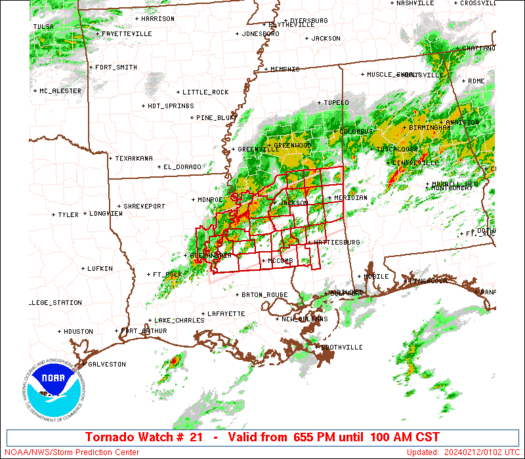
Tornado Watch Number 21
NWS Storm Prediction Center Norman OK
655 PM CST Sun Feb 11 2024
The NWS Storm Prediction Center has issued a
* Tornado Watch for portions of
East Central Louisiana
Central and Southern Mississippi
* Effective this Sunday night and Monday morning from 655 PM
until 100 AM CST.
* Primary threats include...
A few tornadoes likely with a couple intense tornadoes possible
Scattered large hail and isolated very large hail events to 2
inches in diameter likely
Scattered damaging wind gusts to 70 mph likely
SUMMARY...Scattered thunderstorms will continue to affect parts of
central/southern Mississippi and east-central Louisiana for several
more hours. Sufficient shear and instability will maintain some
risk of supercells capable of large hail, damaging winds, and
tornadoes.
The tornado watch area is approximately along and 45 statute miles
north and south of a line from 30 miles west southwest of Natchez MS
to 20 miles east of Meridian MS. For a complete depiction of the
watch see the associated watch outline update (WOUS64 KWNS WOU1).
PRECAUTIONARY/PREPAREDNESS ACTIONS...
REMEMBER...A Tornado Watch means conditions are favorable for
tornadoes and severe thunderstorms in and close to the watch
area. Persons in these areas should be on the lookout for
threatening weather conditions and listen for later statements
and possible warnings.
&&
OTHER WATCH INFORMATION...CONTINUE...WW 20...
AVIATION...Tornadoes and a few severe thunderstorms with hail
surface and aloft to 2 inches. Extreme turbulence and surface wind
gusts to 60 knots. A few cumulonimbi with maximum tops to 450. Mean
storm motion vector 25035.
...Hart

   SEL1

   URGENT - IMMEDIATE BROADCAST REQUESTED
   Tornado Watch Number 21
   NWS Storm Prediction Center Norman OK
   655 PM CST Sun Feb 11 2024

   The NWS Storm Prediction Center has issued a

   * Tornado Watch for portions of
     East Central Louisiana
     Central and Southern Mississippi

   * Effective this Sunday night and Monday morning from 655 PM
     until 100 AM CST.

   * Primary threats include...
     A few tornadoes likely with a couple intense tornadoes possible
     Scattered large hail and isolated very large hail events to 2
       inches in diameter likely
     Scattered damaging wind gusts to 70 mph likely

   SUMMARY...Scattered thunderstorms will continue to affect parts of
   central/southern Mississippi and east-central Louisiana for several
   more hours.  Sufficient shear and instability will maintain some
   risk of supercells capable of large hail, damaging winds, and
   tornadoes.

   The tornado watch area is approximately along and 45 statute miles
   north and south of a line from 30 miles west southwest of Natchez MS
   to 20 miles east of Meridian MS. For a complete depiction of the
   watch see the associated watch outline update (WOUS64 KWNS WOU1).

   PRECAUTIONARY/PREPAREDNESS ACTIONS...

   REMEMBER...A Tornado Watch means conditions are favorable for
   tornadoes and severe thunderstorms in and close to the watch
   area. Persons in these areas should be on the lookout for
   threatening weather conditions and listen for later statements
   and possible warnings.

   &&

   OTHER WATCH INFORMATION...CONTINUE...WW 20...

   AVIATION...Tornadoes and a few severe thunderstorms with hail
   surface and aloft to 2 inches. Extreme turbulence and surface wind
   gusts to 60 knots. A few cumulonimbi with maximum tops to 450. Mean
   storm motion vector 25035.

   ...Hart
 Note:
The Aviation Watch (SAW) product is an approximation to the watch area.
The actual watch is depicted by the shaded areas.
Note:
The Aviation Watch (SAW) product is an approximation to the watch area.
The actual watch is depicted by the shaded areas.
   SAW1
   WW 21 TORNADO LA MS 120055Z - 120700Z
   AXIS..45 STATUTE MILES NORTH AND SOUTH OF LINE..
   30WSW HEZ/NATCHEZ MS/ - 20E MEI/MERIDIAN MS/
   ..AVIATION COORDS.. 40NM N/S /39ENE AEX - 20E MEI/
   HAIL SURFACE AND ALOFT..2 INCHES. WIND GUSTS..60 KNOTS.
   MAX TOPS TO 450. MEAN STORM MOTION VECTOR 25035.

   LAT...LON 32099177 32988841 31688841 30809177

   THIS IS AN APPROXIMATION TO THE WATCH AREA.  FOR A
   COMPLETE DEPICTION OF THE WATCH SEE WOUS64 KWNS
   FOR WOU1.
Watch 21 Status Report Messages:
STATUS REPORT #4 ON WW 21
VALID 120640Z - 120700Z
SEVERE WEATHER THREAT CONTINUES RIGHT OF A LINE FROM 45 S HEZ TO
55 NW PIB TO 45 NNE MEI.
EITHER REMAINING VALID PORTION OF WW 21 WILL BE LOCALLY EXTENDED IN
TIME OR A NEW WW WILL BE ISSUED PRIOR TO 07Z.
..KERR..02/12/24
ATTN...WFO...JAN...LIX...
&&
STATUS REPORT FOR WT 21
SEVERE WEATHER THREAT CONTINUES FOR THE FOLLOWING AREAS
LAC005-007-033-037-047-063-091-093-095-105-121-120700-
LA
. LOUISIANA PARISHES INCLUDED ARE
ASCENSION ASSUMPTION EAST BATON ROUGE
EAST FELICIANA IBERVILLE LIVINGSTON
ST. HELENA ST. JAMES ST. JOHN THE BAPTIST
TANGIPAHOA WEST BATON ROUGE
$$
MSC005-023-029-031-035-061-065-067-069-073-075-077-091-101-113-
121-123-127-129-147-120700-
MS
. MISSISSIPPI COUNTIES INCLUDED ARE
AMITE CLARKE COPIAH
COVINGTON FORREST JASPER
JEFFERSON DAVIS JONES KEMPER
LAMAR LAUDERDALE LAWRENCE
MARION NEWTON PIKE
RANKIN SCOTT SIMPSON
SMITH WALTHALL
$$
THE WATCH STATUS MESSAGE IS FOR GUIDANCE PURPOSES ONLY. PLEASE
REFER TO WATCH COUNTY NOTIFICATION STATEMENTS FOR OFFICIAL
INFORMATION ON COUNTIES...INDEPENDENT CITIES AND MARINE ZONES
CLEARED FROM SEVERE THUNDERSTORM AND TORNADO WATCHES.
$$
STATUS REPORT #3 ON WW 21
VALID 120530Z - 120640Z
SEVERE WEATHER THREAT CONTINUES RIGHT OF A LINE FROM 45 N LFT TO
25 SE HEZ TO 45 SW CBM.
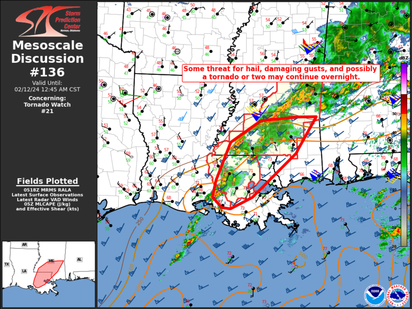
FOR ADDITIONAL INFORMATION SEE MESOSCALE DISCUSSION 136
..DEAN..02/12/24
ATTN...WFO...JAN...LIX...
&&
STATUS REPORT FOR WT 21
SEVERE WEATHER THREAT CONTINUES FOR THE FOLLOWING AREAS
LAC005-007-033-037-047-063-077-091-093-095-105-121-125-120640-
LA
. LOUISIANA PARISHES INCLUDED ARE
ASCENSION ASSUMPTION EAST BATON ROUGE
EAST FELICIANA IBERVILLE LIVINGSTON
POINTE COUPEE ST. HELENA ST. JAMES
ST. JOHN THE BAPTIST TANGIPAHOA WEST BATON ROUGE
WEST FELICIANA
$$
MSC005-023-029-031-035-037-061-065-067-069-073-075-077-085-091-
099-101-113-121-123-127-129-147-157-120640-
MS
. MISSISSIPPI COUNTIES INCLUDED ARE
AMITE CLARKE COPIAH
COVINGTON FORREST FRANKLIN
JASPER JEFFERSON DAVIS JONES
KEMPER LAMAR LAUDERDALE
LAWRENCE LINCOLN MARION
NESHOBA NEWTON PIKE
RANKIN SCOTT SIMPSON
SMITH WALTHALL WILKINSON
$$
THE WATCH STATUS MESSAGE IS FOR GUIDANCE PURPOSES ONLY. PLEASE
REFER TO WATCH COUNTY NOTIFICATION STATEMENTS FOR OFFICIAL
INFORMATION ON COUNTIES...INDEPENDENT CITIES AND MARINE ZONES
CLEARED FROM SEVERE THUNDERSTORM AND TORNADO WATCHES.
$$
STATUS REPORT #2 ON WW 21
VALID 120420Z - 120540Z
SEVERE WEATHER THREAT CONTINUES RIGHT OF A LINE FROM 5 ENE ESF TO
40 ENE HEZ TO 35 S GWO.
..DEAN..02/12/24
ATTN...WFO...JAN...LIX...
&&
STATUS REPORT FOR WT 21
SEVERE WEATHER THREAT CONTINUES FOR THE FOLLOWING AREAS
LAC005-007-029-033-037-047-063-077-091-093-095-105-121-125-
120540-
LA
. LOUISIANA PARISHES INCLUDED ARE
ASCENSION ASSUMPTION CONCORDIA
EAST BATON ROUGE EAST FELICIANA IBERVILLE
LIVINGSTON POINTE COUPEE ST. HELENA
ST. JAMES ST. JOHN THE BAPTISTTANGIPAHOA
WEST BATON ROUGE WEST FELICIANA
$$
MSC001-005-023-029-031-035-037-049-061-063-065-067-069-073-075-
077-079-085-089-091-099-101-113-121-123-127-129-147-157-
120540-
MS
. MISSISSIPPI COUNTIES INCLUDED ARE
ADAMS AMITE CLARKE
COPIAH COVINGTON FORREST
FRANKLIN HINDS JASPER
JEFFERSON JEFFERSON DAVIS JONES
KEMPER LAMAR LAUDERDALE
LAWRENCE LEAKE LINCOLN
MADISON MARION NESHOBA
NEWTON PIKE RANKIN
SCOTT SIMPSON SMITH
WALTHALL WILKINSON
$$
THE WATCH STATUS MESSAGE IS FOR GUIDANCE PURPOSES ONLY. PLEASE
REFER TO WATCH COUNTY NOTIFICATION STATEMENTS FOR OFFICIAL
INFORMATION ON COUNTIES...INDEPENDENT CITIES AND MARINE ZONES
CLEARED FROM SEVERE THUNDERSTORM AND TORNADO WATCHES.
$$
STATUS REPORT #1 ON WW 21
VALID 120205Z - 120340Z
THE SEVERE WEATHER THREAT CONTINUES ACROSS THE ENTIRE WATCH AREA.
..DEAN..02/12/24
ATTN...WFO...JAN...LIX...
&&
STATUS REPORT FOR WT 21
SEVERE WEATHER THREAT CONTINUES FOR THE FOLLOWING AREAS
LAC025-029-107-120340-
LA
. LOUISIANA PARISHES INCLUDED ARE
CATAHOULA CONCORDIA TENSAS
$$
MSC001-005-021-023-029-031-035-037-049-061-063-065-067-069-073-
075-077-079-085-089-091-099-101-113-121-123-127-129-147-149-157-
120340-
MS
. MISSISSIPPI COUNTIES INCLUDED ARE
ADAMS AMITE CLAIBORNE
CLARKE COPIAH COVINGTON
FORREST FRANKLIN HINDS
JASPER JEFFERSON JEFFERSON DAVIS
JONES KEMPER LAMAR
LAUDERDALE LAWRENCE LEAKE
LINCOLN MADISON MARION
NESHOBA NEWTON PIKE
RANKIN SCOTT SIMPSON
SMITH WALTHALL WARREN
WILKINSON
$$
THE WATCH STATUS MESSAGE IS FOR GUIDANCE PURPOSES ONLY. PLEASE
REFER TO WATCH COUNTY NOTIFICATION STATEMENTS FOR OFFICIAL
INFORMATION ON COUNTIES...INDEPENDENT CITIES AND MARINE ZONES
CLEARED FROM SEVERE THUNDERSTORM AND TORNADO WATCHES.
$$
Note:
Click for Complete Product Text.
Tornadoes
Probability of 2 or more tornadoes
|
Mod (60%)
|
Probability of 1 or more strong (EF2-EF5) tornadoes
|
Mod (40%)
|
Wind
Probability of 10 or more severe wind events
|
Mod (60%)
|
Probability of 1 or more wind events > 65 knots
|
Low (20%)
|
Hail
Probability of 10 or more severe hail events
|
Mod (60%)
|
Probability of 1 or more hailstones > 2 inches
|
Mod (60%)
|
Combined Severe Hail/Wind
Probability of 6 or more combined severe hail/wind events
|
High (>95%)
|
For each watch, probabilities for particular events inside the watch
(listed above in each table) are determined by the issuing forecaster.
The "Low" category contains probability values ranging from less than 2%
to 20% (EF2-EF5 tornadoes), less than 5% to 20% (all other probabilities),
"Moderate" from 30% to 60%, and "High" from 70% to greater than 95%.
High values are bolded and lighter in color to provide awareness of
an increased threat for a particular event.


 @NWSSPC