Note:
The expiration time in the watch graphic is amended if the watch is
replaced, cancelled or extended.
Note:
Note:
The expiration time in the watch graphic is amended if the watch is
replaced, cancelled or extended.
Note: Click for
Watch Status Reports.
SEL8
URGENT - IMMEDIATE BROADCAST REQUESTED
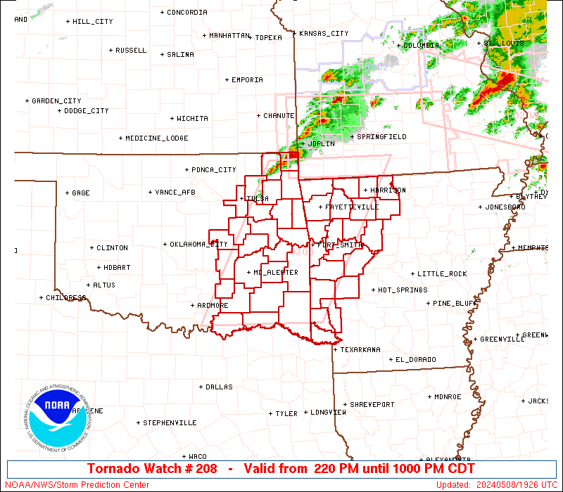
Tornado Watch Number 208
NWS Storm Prediction Center Norman OK
220 PM CDT Wed May 8 2024
The NWS Storm Prediction Center has issued a
* Tornado Watch for portions of
Western Arkansas
Eastern Oklahoma
* Effective this Wednesday afternoon and evening from 220 PM
until 1000 PM CDT.
* Primary threats include...
A few tornadoes likely with a couple intense tornadoes possible
Scattered damaging winds and isolated significant gusts to 75
mph likely
Scattered large hail and isolated very large hail events to 4
inches in diameter likely
SUMMARY...Scattered supercells are forecast to develop across
eastern Oklahoma late this afternoon and move into western Arkansas
late this afternoon into the evening. Giant hail is possible with
the more intense supercells, in addition to the risk for a strong
tornado.
The tornado watch area is approximately along and 75 statute miles
east and west of a line from Monett MO to 50 miles east of Durant
OK. For a complete depiction of the watch see the associated watch
outline update (WOUS64 KWNS WOU8).
PRECAUTIONARY/PREPAREDNESS ACTIONS...
REMEMBER...A Tornado Watch means conditions are favorable for
tornadoes and severe thunderstorms in and close to the watch
area. Persons in these areas should be on the lookout for
threatening weather conditions and listen for later statements
and possible warnings.
&&
OTHER WATCH INFORMATION...CONTINUE...WW 203...WW 204...WW
205...WW 206...WW 207...
AVIATION...Tornadoes and a few severe thunderstorms with hail
surface and aloft to 4 inches. Extreme turbulence and surface wind
gusts to 65 knots. A few cumulonimbi with maximum tops to 500. Mean
storm motion vector 25030.
...Smith

   SEL8

   URGENT - IMMEDIATE BROADCAST REQUESTED
   Tornado Watch Number 208
   NWS Storm Prediction Center Norman OK
   220 PM CDT Wed May 8 2024

   The NWS Storm Prediction Center has issued a

   * Tornado Watch for portions of
     Western Arkansas
     Eastern Oklahoma

   * Effective this Wednesday afternoon and evening from 220 PM
     until 1000 PM CDT.

   * Primary threats include...
     A few tornadoes likely with a couple intense tornadoes possible
     Scattered damaging winds and isolated significant gusts to 75
       mph likely
     Scattered large hail and isolated very large hail events to 4
       inches in diameter likely

   SUMMARY...Scattered supercells are forecast to develop across
   eastern Oklahoma late this afternoon and move into western Arkansas
   late this afternoon into the evening.  Giant hail is possible with
   the more intense supercells, in addition to the risk for a strong
   tornado.

   The tornado watch area is approximately along and 75 statute miles
   east and west of a line from Monett MO to 50 miles east of Durant
   OK. For a complete depiction of the watch see the associated watch
   outline update (WOUS64 KWNS WOU8).

   PRECAUTIONARY/PREPAREDNESS ACTIONS...

   REMEMBER...A Tornado Watch means conditions are favorable for
   tornadoes and severe thunderstorms in and close to the watch
   area. Persons in these areas should be on the lookout for
   threatening weather conditions and listen for later statements
   and possible warnings.

   &&

   OTHER WATCH INFORMATION...CONTINUE...WW 203...WW 204...WW
   205...WW 206...WW 207...

   AVIATION...Tornadoes and a few severe thunderstorms with hail
   surface and aloft to 4 inches. Extreme turbulence and surface wind
   gusts to 65 knots. A few cumulonimbi with maximum tops to 500. Mean
   storm motion vector 25030.

   ...Smith
 Note:
The Aviation Watch (SAW) product is an approximation to the watch area.
The actual watch is depicted by the shaded areas.
Note:
The Aviation Watch (SAW) product is an approximation to the watch area.
The actual watch is depicted by the shaded areas.
   SAW8
   WW 208 TORNADO AR OK 081920Z - 090300Z
   AXIS..75 STATUTE MILES EAST AND WEST OF LINE..
   UMN/MONETT MO/ - 50E DUA/DURANT OK/
   ..AVIATION COORDS.. 65NM E/W /39NNE RZC - 56SSE MLC/
   HAIL SURFACE AND ALOFT..4 INCHES. WIND GUSTS..65 KNOTS.
   MAX TOPS TO 500. MEAN STORM MOTION VECTOR 25030.

   LAT...LON 36879254 33939422 33939684 36879526

   THIS IS AN APPROXIMATION TO THE WATCH AREA.  FOR A
   COMPLETE DEPICTION OF THE WATCH SEE WOUS64 KWNS
   FOR WOU8.
Watch 208 Status Report Messages:
STATUS REPORT #8 ON WW 208

VALID 090240Z - 090340Z

SEVERE WEATHER THREAT CONTINUES RIGHT OF A LINE FROM 30 WSW DEQ
TO 10 WNW DEQ TO 25 NW RKR TO 15 SSW FYV TO 5 SSW HRO TO 15 NNW
FLP.

FOR ADDITIONAL INFORMATION SEE MESOSCALE DISCUSSION 719

..WENDT..05/09/24

ATTN...WFO...TSA...LZK...SHV...OUN...

&&

STATUS REPORT FOR WT 208

SEVERE WEATHER THREAT CONTINUES FOR THE FOLLOWING AREAS

ARC033-047-061-071-081-087-089-101-129-131-133-090340-

AR
.    ARKANSAS COUNTIES INCLUDED ARE

CRAWFORD	     FRANKLIN		 HOWARD
JOHNSON 	     LITTLE RIVER	 MADISON
MARION		     NEWTON		 SEARCY
SEBASTIAN	     SEVIER
$$


OKC079-135-090340-

OK
.    OKLAHOMA COUNTIES INCLUDED ARE

LE FLORE	     SEQUOYAH
$$


THE WATCH STATUS MESSAGE IS FOR GUIDANCE PURPOSES ONLY.  PLEASE
REFER TO WATCH COUNTY NOTIFICATION STATEMENTS FOR OFFICIAL
INFORMATION ON COUNTIES...INDEPENDENT CITIES AND MARINE ZONES
CLEARED FROM SEVERE THUNDERSTORM AND TORNADO WATCHES.
$$

STATUS REPORT #7 ON WW 208

VALID 090135Z - 090240Z

SEVERE WEATHER THREAT CONTINUES RIGHT OF A LINE FROM 20 NW PRX TO
40 SE MLC TO 30 W RKR TO 25 NNW FSM TO 15 NE FYV TO 25 NNE HRO.

..BENTLEY..05/09/24

ATTN...WFO...TSA...LZK...SHV...OUN...

&&

STATUS REPORT FOR WT 208

SEVERE WEATHER THREAT CONTINUES FOR THE FOLLOWING AREAS

ARC009-015-033-047-061-071-081-087-089-101-129-131-133-143-
090240-

AR
.    ARKANSAS COUNTIES INCLUDED ARE

BOONE		     CARROLL		 CRAWFORD
FRANKLIN	     HOWARD		 JOHNSON
LITTLE RIVER	     MADISON		 MARION
NEWTON		     SEARCY		 SEBASTIAN
SEVIER		     WASHINGTON
$$


OKC023-061-077-079-089-127-135-090240-

OK
.    OKLAHOMA COUNTIES INCLUDED ARE

CHOCTAW 	     HASKELL		 LATIMER
LE FLORE	     MCCURTAIN		 PUSHMATAHA
SEQUOYAH
$$


THE WATCH STATUS MESSAGE IS FOR GUIDANCE PURPOSES ONLY.  PLEASE
REFER TO WATCH COUNTY NOTIFICATION STATEMENTS FOR OFFICIAL
INFORMATION ON COUNTIES...INDEPENDENT CITIES AND MARINE ZONES
CLEARED FROM SEVERE THUNDERSTORM AND TORNADO WATCHES.
$$

STATUS REPORT #6 ON WW 208

VALID 090110Z - 090240Z

SEVERE WEATHER THREAT CONTINUES RIGHT OF A LINE FROM 25 ESE DUA
TO 20 SE MLC TO 20 SE MKO TO 15 NW FYV TO 35 NNE HRO.

..BENTLEY..05/09/24

ATTN...WFO...TSA...LZK...SHV...OUN...

&&

STATUS REPORT FOR WT 208

SEVERE WEATHER THREAT CONTINUES FOR THE FOLLOWING AREAS

ARC009-015-033-047-061-071-081-083-087-089-097-101-113-115-127-
129-131-133-143-149-090240-

AR
.    ARKANSAS COUNTIES INCLUDED ARE

BOONE		     CARROLL		 CRAWFORD
FRANKLIN	     HOWARD		 JOHNSON
LITTLE RIVER	     LOGAN		 MADISON
MARION		     MONTGOMERY 	 NEWTON
POLK		     POPE		 SCOTT
SEARCY		     SEBASTIAN		 SEVIER
WASHINGTON	     YELL
$$


OKC001-023-061-077-079-089-127-135-090240-

OK
.    OKLAHOMA COUNTIES INCLUDED ARE

ADAIR		     CHOCTAW		 HASKELL
LATIMER 	     LE FLORE		 MCCURTAIN
PUSHMATAHA	     SEQUOYAH
$$


THE WATCH STATUS MESSAGE IS FOR GUIDANCE PURPOSES ONLY.  PLEASE
REFER TO WATCH COUNTY NOTIFICATION STATEMENTS FOR OFFICIAL
INFORMATION ON COUNTIES...INDEPENDENT CITIES AND MARINE ZONES
CLEARED FROM SEVERE THUNDERSTORM AND TORNADO WATCHES.
$$

STATUS REPORT #5 ON WW 208

VALID 090010Z - 090140Z

SEVERE WEATHER THREAT CONTINUES RIGHT OF A LINE FROM 15 ESE GYI
TO 35 NE DUA TO 30 SSW MKO TO 15 NNE MKO TO 25 S GMJ TO 20 SE UMN
TO 30 ESE SGF.

..BENTLEY..05/09/24

ATTN...WFO...TSA...LZK...SHV...OUN...

&&

STATUS REPORT FOR WT 208

SEVERE WEATHER THREAT CONTINUES FOR THE FOLLOWING AREAS

ARC007-009-015-033-047-061-071-081-083-087-089-097-101-113-115-
127-129-131-133-143-149-090140-

AR
.    ARKANSAS COUNTIES INCLUDED ARE

BENTON		     BOONE		 CARROLL
CRAWFORD	     FRANKLIN		 HOWARD
JOHNSON 	     LITTLE RIVER	 LOGAN
MADISON 	     MARION		 MONTGOMERY
NEWTON		     POLK		 POPE
SCOTT		     SEARCY		 SEBASTIAN
SEVIER		     WASHINGTON 	 YELL
$$


OKC001-005-013-021-023-041-061-077-079-089-091-101-121-127-135-
090140-

OK
.    OKLAHOMA COUNTIES INCLUDED ARE

ADAIR		     ATOKA		 BRYAN
CHEROKEE	     CHOCTAW		 DELAWARE
HASKELL 	     LATIMER		 LE FLORE
MCCURTAIN	     MCINTOSH		 MUSKOGEE
PITTSBURG	     PUSHMATAHA 	 SEQUOYAH
$$


THE WATCH STATUS MESSAGE IS FOR GUIDANCE PURPOSES ONLY.  PLEASE
REFER TO WATCH COUNTY NOTIFICATION STATEMENTS FOR OFFICIAL
INFORMATION ON COUNTIES...INDEPENDENT CITIES AND MARINE ZONES
CLEARED FROM SEVERE THUNDERSTORM AND TORNADO WATCHES.
$$

STATUS REPORT #4 ON WW 208

VALID 082330Z - 090040Z

SEVERE WEATHER THREAT CONTINUES RIGHT OF A LINE FROM 10 NE GYI TO
15 W MLC TO 15 NW MKO TO 10 SW GMJ TO 20 SW SGF.

..BENTLEY..05/08/24

ATTN...WFO...TSA...LZK...SHV...OUN...

&&

STATUS REPORT FOR WT 208

SEVERE WEATHER THREAT CONTINUES FOR THE FOLLOWING AREAS

ARC007-009-015-033-047-061-071-081-083-087-089-097-101-113-115-
127-129-131-133-143-149-090040-

AR
.    ARKANSAS COUNTIES INCLUDED ARE

BENTON		     BOONE		 CARROLL
CRAWFORD	     FRANKLIN		 HOWARD
JOHNSON 	     LITTLE RIVER	 LOGAN
MADISON 	     MARION		 MONTGOMERY
NEWTON		     POLK		 POPE
SCOTT		     SEARCY		 SEBASTIAN
SEVIER		     WASHINGTON 	 YELL
$$


OKC001-005-013-021-023-041-061-077-079-089-091-101-121-127-135-
090040-

OK
.    OKLAHOMA COUNTIES INCLUDED ARE

ADAIR		     ATOKA		 BRYAN
CHEROKEE	     CHOCTAW		 DELAWARE
HASKELL 	     LATIMER		 LE FLORE
MCCURTAIN	     MCINTOSH		 MUSKOGEE
PITTSBURG	     PUSHMATAHA 	 SEQUOYAH
$$


THE WATCH STATUS MESSAGE IS FOR GUIDANCE PURPOSES ONLY.  PLEASE
REFER TO WATCH COUNTY NOTIFICATION STATEMENTS FOR OFFICIAL
INFORMATION ON COUNTIES...INDEPENDENT CITIES AND MARINE ZONES
CLEARED FROM SEVERE THUNDERSTORM AND TORNADO WATCHES.
$$

STATUS REPORT #3 ON WW 208

VALID 082240Z - 082340Z

SEVERE WEATHER THREAT CONTINUES RIGHT OF A LINE FROM 35 SSW TUL
TO 20 SE TUL TO 20 SW GMJ TO 20 SSE JLN.

..BENTLEY..05/08/24

ATTN...WFO...TSA...LZK...SHV...OUN...

&&

STATUS REPORT FOR WT 208

SEVERE WEATHER THREAT CONTINUES FOR THE FOLLOWING AREAS

ARC007-009-015-033-047-061-071-081-083-087-089-097-101-113-115-
127-129-131-133-143-149-082340-

AR
.    ARKANSAS COUNTIES INCLUDED ARE

BENTON		     BOONE		 CARROLL
CRAWFORD	     FRANKLIN		 HOWARD
JOHNSON 	     LITTLE RIVER	 LOGAN
MADISON 	     MARION		 MONTGOMERY
NEWTON		     POLK		 POPE
SCOTT		     SEARCY		 SEBASTIAN
SEVIER		     WASHINGTON 	 YELL
$$


OKC001-005-013-021-023-029-041-061-063-077-079-089-091-097-101-
121-127-135-145-082340-

OK
.    OKLAHOMA COUNTIES INCLUDED ARE

ADAIR		     ATOKA		 BRYAN
CHEROKEE	     CHOCTAW		 COAL
DELAWARE	     HASKELL		 HUGHES
LATIMER 	     LE FLORE		 MCCURTAIN
MCINTOSH	     MAYES		 MUSKOGEE
PITTSBURG	     PUSHMATAHA 	 SEQUOYAH
WAGONER
$$


THE WATCH STATUS MESSAGE IS FOR GUIDANCE PURPOSES ONLY.  PLEASE
REFER TO WATCH COUNTY NOTIFICATION STATEMENTS FOR OFFICIAL
INFORMATION ON COUNTIES...INDEPENDENT CITIES AND MARINE ZONES
CLEARED FROM SEVERE THUNDERSTORM AND TORNADO WATCHES.
$$

STATUS REPORT #2 ON WW 208

VALID 082140Z - 082240Z

THE SEVERE WEATHER THREAT CONTINUES ACROSS THE ENTIRE WATCH AREA.

..BENTLEY..05/08/24

ATTN...WFO...TSA...LZK...SHV...OUN...

&&

STATUS REPORT FOR WT 208

SEVERE WEATHER THREAT CONTINUES FOR THE FOLLOWING AREAS

ARC007-009-015-033-047-061-071-081-083-087-089-097-101-113-115-
127-129-131-133-143-149-082240-

AR
.    ARKANSAS COUNTIES INCLUDED ARE

BENTON		     BOONE		 CARROLL
CRAWFORD	     FRANKLIN		 HOWARD
JOHNSON 	     LITTLE RIVER	 LOGAN
MADISON 	     MARION		 MONTGOMERY
NEWTON		     POLK		 POPE
SCOTT		     SEARCY		 SEBASTIAN
SEVIER		     WASHINGTON 	 YELL
$$


OKC001-005-013-021-023-029-035-041-061-063-077-079-089-091-097-
101-107-111-115-121-127-131-135-143-145-082240-

OK
.    OKLAHOMA COUNTIES INCLUDED ARE

ADAIR		     ATOKA		 BRYAN
CHEROKEE	     CHOCTAW		 COAL
CRAIG		     DELAWARE		 HASKELL
HUGHES		     LATIMER		 LE FLORE
MCCURTAIN	     MCINTOSH		 MAYES
MUSKOGEE	     OKFUSKEE		 OKMULGEE
OTTAWA		     PITTSBURG		 PUSHMATAHA
ROGERS		     SEQUOYAH		 TULSA
WAGONER
$$


THE WATCH STATUS MESSAGE IS FOR GUIDANCE PURPOSES ONLY.  PLEASE
REFER TO WATCH COUNTY NOTIFICATION STATEMENTS FOR OFFICIAL
INFORMATION ON COUNTIES...INDEPENDENT CITIES AND MARINE ZONES
CLEARED FROM SEVERE THUNDERSTORM AND TORNADO WATCHES.
$$

STATUS REPORT #1 ON WW 208

VALID 082020Z - 082140Z

THE SEVERE WEATHER THREAT CONTINUES ACROSS THE ENTIRE WATCH AREA.

..BENTLEY..05/08/24

ATTN...WFO...TSA...LZK...SHV...OUN...

&&

STATUS REPORT FOR WT 208

SEVERE WEATHER THREAT CONTINUES FOR THE FOLLOWING AREAS

ARC007-009-015-033-047-061-071-081-083-087-089-097-101-113-115-
127-129-131-133-143-149-082140-

AR
.    ARKANSAS COUNTIES INCLUDED ARE

BENTON		     BOONE		 CARROLL
CRAWFORD	     FRANKLIN		 HOWARD
JOHNSON 	     LITTLE RIVER	 LOGAN
MADISON 	     MARION		 MONTGOMERY
NEWTON		     POLK		 POPE
SCOTT		     SEARCY		 SEBASTIAN
SEVIER		     WASHINGTON 	 YELL
$$


OKC001-005-013-021-023-029-035-041-061-063-077-079-089-091-097-
101-107-111-115-121-127-131-135-143-145-082140-

OK
.    OKLAHOMA COUNTIES INCLUDED ARE

ADAIR		     ATOKA		 BRYAN
CHEROKEE	     CHOCTAW		 COAL
CRAIG		     DELAWARE		 HASKELL
HUGHES		     LATIMER		 LE FLORE
MCCURTAIN	     MCINTOSH		 MAYES
MUSKOGEE	     OKFUSKEE		 OKMULGEE
OTTAWA		     PITTSBURG		 PUSHMATAHA
ROGERS		     SEQUOYAH		 TULSA
WAGONER
$$


THE WATCH STATUS MESSAGE IS FOR GUIDANCE PURPOSES ONLY.  PLEASE
REFER TO WATCH COUNTY NOTIFICATION STATEMENTS FOR OFFICIAL
INFORMATION ON COUNTIES...INDEPENDENT CITIES AND MARINE ZONES
CLEARED FROM SEVERE THUNDERSTORM AND TORNADO WATCHES.
$$
Note:
Click for Complete Product Text.
Tornadoes
Probability of 2 or more tornadoes
|
Mod (60%)
|
Probability of 1 or more strong (EF2-EF5) tornadoes
|
Mod (50%)
|
Wind
Probability of 10 or more severe wind events
|
Mod (60%)
|
Probability of 1 or more wind events > 65 knots
|
Mod (60%)
|
Hail
Probability of 10 or more severe hail events
|
High (70%)
|
Probability of 1 or more hailstones > 2 inches
|
Mod (60%)
|
Combined Severe Hail/Wind
Probability of 6 or more combined severe hail/wind events
|
High (>95%)
|
For each watch, probabilities for particular events inside the watch
(listed above in each table) are determined by the issuing forecaster.
The "Low" category contains probability values ranging from less than 2%
to 20% (EF2-EF5 tornadoes), less than 5% to 20% (all other probabilities),
"Moderate" from 30% to 60%, and "High" from 70% to greater than 95%.
High values are bolded and lighter in color to provide awareness of
an increased threat for a particular event.


 @NWSSPC