Note:
The expiration time in the watch graphic is amended if the watch is
replaced, cancelled or extended.
Note:
Note:
The expiration time in the watch graphic is amended if the watch is
replaced, cancelled or extended.
Note: Click for
Watch Status Reports.
SEL9
URGENT - IMMEDIATE BROADCAST REQUESTED
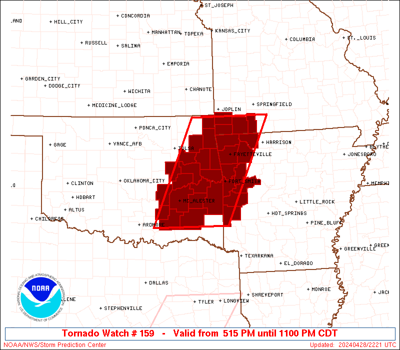
Tornado Watch Number 159
NWS Storm Prediction Center Norman OK
515 PM CDT Sun Apr 28 2024
The NWS Storm Prediction Center has issued a
* Tornado Watch for portions of
Western Arkansas
Southwest Missouri
Eastern Oklahoma
* Effective this Sunday afternoon and evening from 515 PM until
1100 PM CDT.
* Primary threats include...
A couple tornadoes possible
Scattered damaging wind gusts to 70 mph possible
Scattered large hail events to 1.5 inches in diameter possible
SUMMARY...Storms will gradually intensify into the early evening
across eastern Oklahoma and eventually spread into southwest
Missouri and western Arkansas later this evening. A few supercells
are possible as storms mature this evening. Low-level shear and
moist conditions in the low levels will support a risk for a couple
of tornadoes with the stronger storms. Large hail and damaging
gusts are also possible with the stronger storms.
The tornado watch area is approximately along and 65 statute miles
east and west of a line from 15 miles west northwest of Monett MO to
50 miles south southeast of Mcalester OK. For a complete depiction
of the watch see the associated watch outline update (WOUS64 KWNS
WOU9).
PRECAUTIONARY/PREPAREDNESS ACTIONS...
REMEMBER...A Tornado Watch means conditions are favorable for
tornadoes and severe thunderstorms in and close to the watch
area. Persons in these areas should be on the lookout for
threatening weather conditions and listen for later statements
and possible warnings.
&&
OTHER WATCH INFORMATION...CONTINUE...WW 158...
AVIATION...Tornadoes and a few severe thunderstorms with hail
surface and aloft to 1.5 inches. Extreme turbulence and surface wind
gusts to 60 knots. A few cumulonimbi with maximum tops to 400. Mean
storm motion vector 23030.
...Smith
 Note:
The Aviation Watch (SAW) product is an approximation to the watch area.
The actual watch is depicted by the shaded areas.
Note:
The Aviation Watch (SAW) product is an approximation to the watch area.
The actual watch is depicted by the shaded areas.
   SAW9
   WW 159 TORNADO AR MO OK 282215Z - 290400Z
   AXIS..65 STATUTE MILES EAST AND WEST OF LINE..
   15WNW UMN/MONETT MO/ - 50SSE MLC/MCALESTER OK/
   ..AVIATION COORDS.. 55NM E/W /43N RZC - 42SSE MLC/
   HAIL SURFACE AND ALOFT..1.5 INCHES. WIND GUSTS..60 KNOTS.
   MAX TOPS TO 400. MEAN STORM MOTION VECTOR 23030.

   LAT...LON 36969297 34219431 34219658 36969533

   THIS IS AN APPROXIMATION TO THE WATCH AREA.  FOR A
   COMPLETE DEPICTION OF THE WATCH SEE WOUS64 KWNS
   FOR WOU9.
Watch 159 Status Report Messages:
STATUS REPORT #3 ON WW 159
VALID 290155Z - 290240Z
SEVERE WEATHER THREAT CONTINUES RIGHT OF A LINE FROM 35 NNW PRX
TO 30 S RKR TO 5 SW SGF.
..THORNTON..04/29/24
ATTN...WFO...TSA...LZK...SGF...OUN...
&&
STATUS REPORT FOR WT 159
SEVERE WEATHER THREAT CONTINUES FOR THE FOLLOWING AREAS
ARC015-047-083-087-113-127-131-290240-
AR
. ARKANSAS COUNTIES INCLUDED ARE
CARROLL FRANKLIN LOGAN
MADISON POLK SCOTT
SEBASTIAN
$$
MOC209-290240-
MO
. MISSOURI COUNTIES INCLUDED ARE
STONE
$$
THE WATCH STATUS MESSAGE IS FOR GUIDANCE PURPOSES ONLY. PLEASE
REFER TO WATCH COUNTY NOTIFICATION STATEMENTS FOR OFFICIAL
INFORMATION ON COUNTIES...INDEPENDENT CITIES AND MARINE ZONES
CLEARED FROM SEVERE THUNDERSTORM AND TORNADO WATCHES.
$$
STATUS REPORT #2 ON WW 159
VALID 290120Z - 290240Z
SEVERE WEATHER THREAT CONTINUES RIGHT OF A LINE FROM 25 NE DUA TO
25 NW FYV TO 25 NNW UMN.
..THORNTON..04/29/24
ATTN...WFO...TSA...LZK...SGF...OUN...
&&
STATUS REPORT FOR WT 159
SEVERE WEATHER THREAT CONTINUES FOR THE FOLLOWING AREAS
ARC007-015-033-047-083-087-113-127-131-143-290240-
AR
. ARKANSAS COUNTIES INCLUDED ARE
BENTON CARROLL CRAWFORD
FRANKLIN LOGAN MADISON
POLK SCOTT SEBASTIAN
WASHINGTON
$$
MOC009-209-290240-
MO
. MISSOURI COUNTIES INCLUDED ARE
BARRY STONE
$$
OKC001-061-077-079-127-135-290240-
OK
. OKLAHOMA COUNTIES INCLUDED ARE
ADAIR HASKELL LATIMER
LE FLORE PUSHMATAHA SEQUOYAH
$$
THE WATCH STATUS MESSAGE IS FOR GUIDANCE PURPOSES ONLY. PLEASE
REFER TO WATCH COUNTY NOTIFICATION STATEMENTS FOR OFFICIAL
INFORMATION ON COUNTIES...INDEPENDENT CITIES AND MARINE ZONES
CLEARED FROM SEVERE THUNDERSTORM AND TORNADO WATCHES.
$$
STATUS REPORT #1 ON WW 159
VALID 290015Z - 290140Z
THE SEVERE WEATHER THREAT CONTINUES ACROSS THE ENTIRE WATCH AREA.
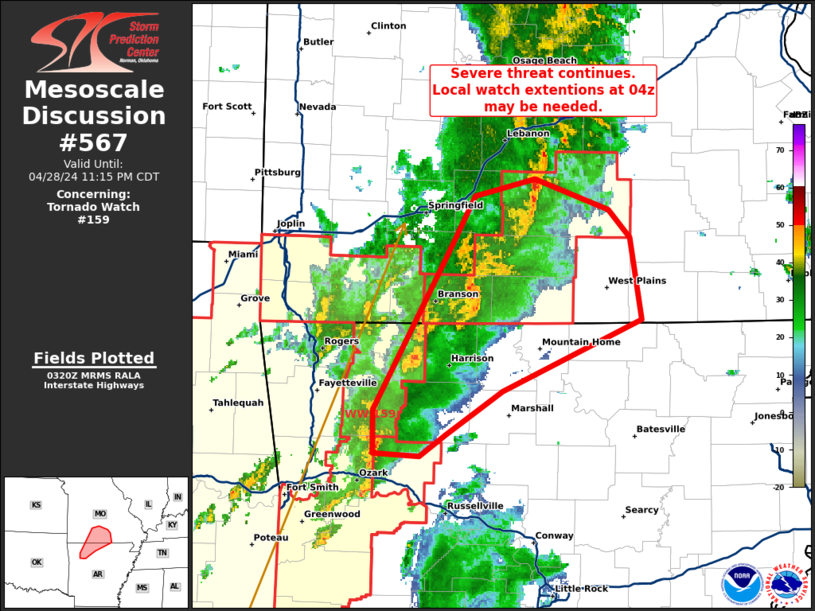
FOR ADDITIONAL INFORMATION SEE MESOSCALE DISCUSSION 565
..THORNTON..04/29/24
ATTN...WFO...TSA...LZK...SGF...OUN...
&&
STATUS REPORT FOR WT 159
SEVERE WEATHER THREAT CONTINUES FOR THE FOLLOWING AREAS
ARC007-015-033-047-083-087-113-127-131-143-290140-
AR
. ARKANSAS COUNTIES INCLUDED ARE
BENTON CARROLL CRAWFORD
FRANKLIN LOGAN MADISON
POLK SCOTT SEBASTIAN
WASHINGTON
$$
MOC009-119-145-209-290140-
MO
. MISSOURI COUNTIES INCLUDED ARE
BARRY MCDONALD NEWTON
STONE
$$
OKC001-005-021-029-041-061-063-077-079-091-097-101-111-115-121-
127-135-145-290140-
OK
. OKLAHOMA COUNTIES INCLUDED ARE
ADAIR ATOKA CHEROKEE
COAL DELAWARE HASKELL
HUGHES LATIMER LE FLORE
MCINTOSH MAYES MUSKOGEE
OKMULGEE OTTAWA PITTSBURG
PUSHMATAHA SEQUOYAH WAGONER
$$
THE WATCH STATUS MESSAGE IS FOR GUIDANCE PURPOSES ONLY. PLEASE
REFER TO WATCH COUNTY NOTIFICATION STATEMENTS FOR OFFICIAL
INFORMATION ON COUNTIES...INDEPENDENT CITIES AND MARINE ZONES
CLEARED FROM SEVERE THUNDERSTORM AND TORNADO WATCHES.
$$
Note:
Click for Complete Product Text.
Tornadoes
Probability of 2 or more tornadoes
|
Mod (30%)
|
Probability of 1 or more strong (EF2-EF5) tornadoes
|
Low (10%)
|
Wind
Probability of 10 or more severe wind events
|
Mod (40%)
|
Probability of 1 or more wind events > 65 knots
|
Low (20%)
|
Hail
Probability of 10 or more severe hail events
|
Mod (40%)
|
Probability of 1 or more hailstones > 2 inches
|
Low (20%)
|
Combined Severe Hail/Wind
Probability of 6 or more combined severe hail/wind events
|
High (70%)
|
For each watch, probabilities for particular events inside the watch
(listed above in each table) are determined by the issuing forecaster.
The "Low" category contains probability values ranging from less than 2%
to 20% (EF2-EF5 tornadoes), less than 5% to 20% (all other probabilities),
"Moderate" from 30% to 60%, and "High" from 70% to greater than 95%.
High values are bolded and lighter in color to provide awareness of
an increased threat for a particular event.


 @NWSSPC