|
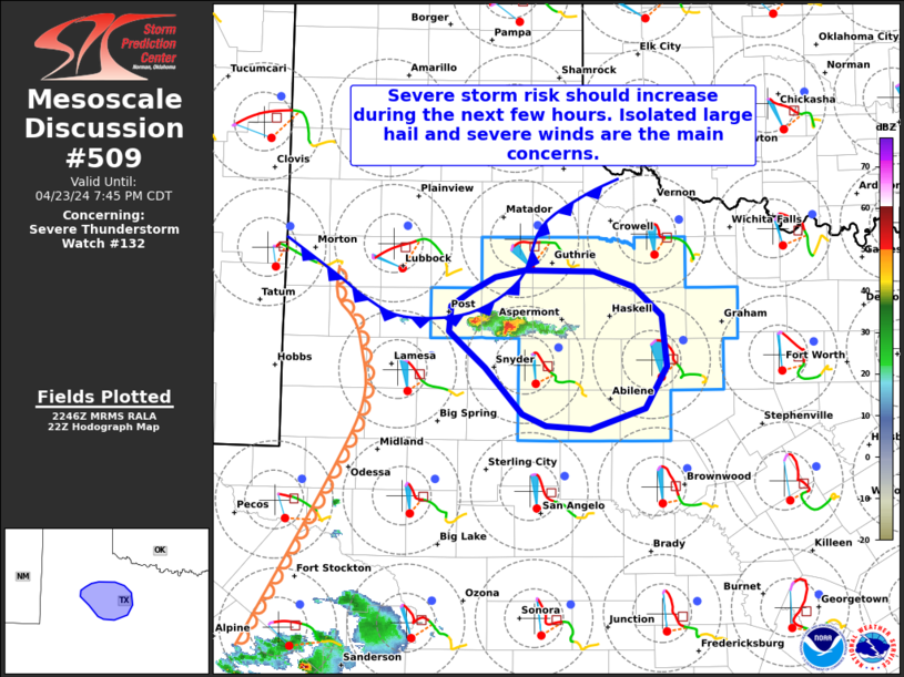
| Mesoscale Discussion 509 |
|
< Previous MD Next MD >
|
|
   Mesoscale Discussion 0509
   NWS Storm Prediction Center Norman OK
   0549 PM CDT Tue Apr 23 2024

   Areas affected...Portions of Northwest Texas

   Concerning...Severe Thunderstorm Watch 132...

   Valid 232249Z - 240045Z

   The severe weather threat for Severe Thunderstorm Watch 132
   continues.

   SUMMARY...The severe storm risk should increase across Severe
   Thunderstorm Watch 132 during the next few hours. Isolated large
   hail (some possibly up to 2.5 inches) and severe gusts to 70 mph are
   the main concerns.

   DISCUSSION...A couple of semi-discrete thunderstorms have developed
   along a cold front draped across The Rolling Plains this afternoon,
   where surface convergence is maximized. So far, these storms have
   struggled to maintain organization and intensity as they attempt to
   get off the boundary. As of 2240Z, these storms are now tracking
   east-southeastward off the boundary, into an environment with richer
   boundary-layer moisture (upper 50s/lower 60s dewpoints) beneath
   steep midlevel lapse rates. Here, a long/mostly straight hodograph
   (characterized by 30-40 kt of effective shear) should support
   supercells (with a tendency for splitting). Weak large-scale ascent
   and warm/dry air at the base of the EML have limited storm
   intensity/sustenance so far. However, continued storm splits and
   related merging may allow for a larger storm structure or two to
   evolve with time. If this convective evolution can occur, isolated
   large hail (up to 2.5 inches in diameter) and severe gusts up to 70
   mph will be an increasing concern during the next few hours.

   ..Weinman.. 04/23/2024

   ...Please see www.spc.noaa.gov for graphic product...

   ATTN...WFO...OUN...SJT...LUB...MAF...

   LAT...LON   32910124 33020136 33230134 33370114 33480090 33550058
               33539989 33409949 33159920 32729914 32369937 32179992
               32210038 32300061 32710100 32910124
|
|
Top/All Mesoscale Discussions/Forecast Products/Home
|
|


 @NWSSPC