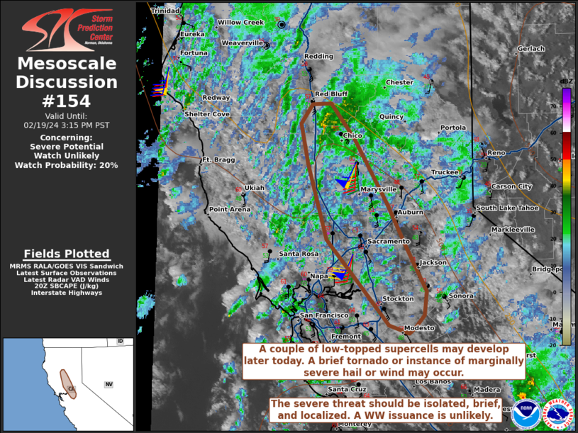
   Mesoscale Discussion 0154
   NWS Storm Prediction Center Norman OK
   0251 PM CST Mon Feb 19 2024

   Areas affected...portions of central into northern California

   Concerning...Severe potential...Watch unlikely

   Valid 192051Z - 192315Z

   Probability of Watch Issuance...20 percent

   SUMMARY...A couple of semi-discrete, low-topped supercells may form
   later this afternoon, accompanied by a brief tornado or marginally
   severe hail/wind risk. A WW issuance appears unlikely given the
   brief, localized nature of the severe threat.

   DISCUSSION...A pronounced mid-level trough and associated surface
   low continue to promote strong flow fields over central into
   northern CA as they linger just offshore. Some clearing of clouds
   and precipitation over portions of the Sacramento Valley have
   allowed surface temperatures to reach the lower to mid 60s F in
   spots. While 7 C/km mid-level lapse rates (per 20Z mesoanalysis)
   overspread the low to mid 60s F temperatures, the diurnal heating
   has also allowed for the mixing of the low-level moisture, with
   surface dewpoints only as high as 50 F in spots. These lower
   dewpoints support thin SBCAPE profiles (no more than 500 J/kg in
   most spots). While the DAX and BBX VADs show relatively large,
   curved hodographs (300+ m2/s2 0-3 km SRH), RAP forecast soundings
   suggest that such low dewpoints do not sufficiently destabilize the
   boundary layer for optimal ingestion of the available SRH. While
   low-topped storms (perhaps supercells) may develop later today with
   a marginally severe hail/wind threat, the tornado risk is a bit more
   uncertain. Nonetheless, if a robust, discrete low-topped supercell
   manages to develop, a brief tornado cannot be ruled out.

   Coverage of robust updrafts over the Sacramento Valley remains
   uncertain, and any severe threat that can materialize should be
   brief and very localized. As such, a WW issuance does not appear
   likely at this time.

   ..Squitieri/Hart.. 02/19/2024

   ...Please see www.spc.noaa.gov for graphic product...

   ATTN...WFO...STO...

   LAT...LON   37722118 38152156 38642204 39472230 39902239 40122223
               40132198 39742164 39032119 38592095 38092066 37822069
               37692082 37622090 37722118
|


 @NWSSPC