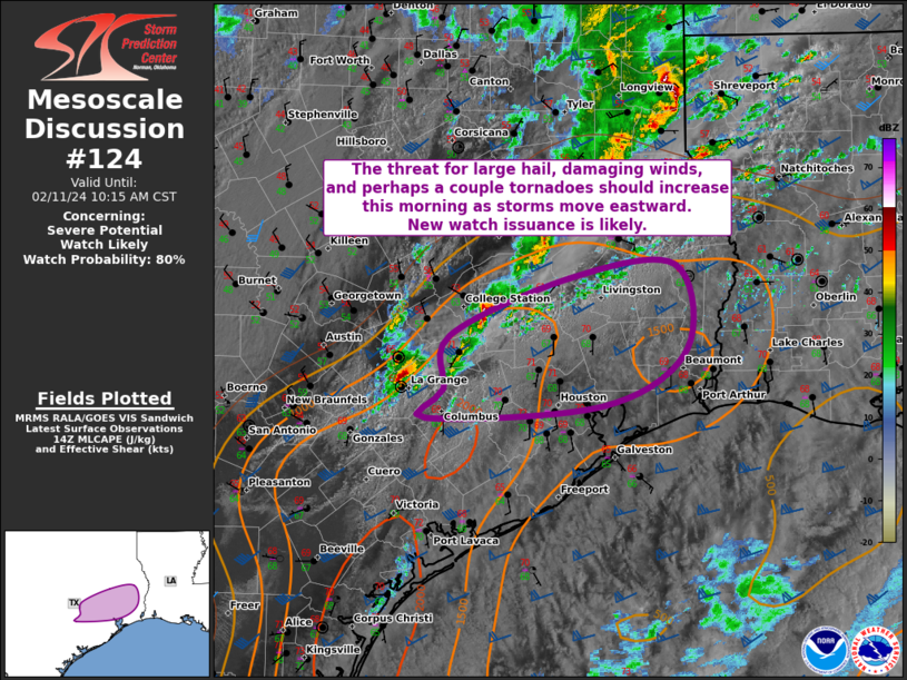
   Mesoscale Discussion 0124
   NWS Storm Prediction Center Norman OK
   0842 AM CST Sun Feb 11 2024

   Areas affected...Portions of southeast TX

   Concerning...Severe potential...Watch likely

   Valid 111442Z - 111615Z

   Probability of Watch Issuance...80 percent

   SUMMARY...The threat for large hail, damaging winds, and perhaps a
   couple of tornadoes should increase this morning as thunderstorms
   move eastward. New watch issuance is likely soon.

   DISCUSSION...A couple of supercells have recently strengthened
   across south-central/southeast TX between Austin/San Antonio and the
   Houston metro. This convection is located along/very near a surface
   front, and its general eastward movement should allow it to remain
   surface based, or very nearly so over the next few hours. Strong
   southwesterly winds at mid levels will and related 45-55 kt of
   deep-layer shear will easily support continued updraft organization,
   including maintenance of ongoing supercell intensity. Steep lapse
   rates aloft and a rich/moist low-level airmass present along/south
   of the boundary are already supporting moderate instability, with
   MLCAPE generally 1500-2000 J/kg. Large hail, some potentially
   greater than 2 inches in diameter, should be the main severe threat
   in the short term. But, isolated severe/damaging winds will also be
   possible in convective downdrafts. The tornado threat is a little
   more uncertain, but recent VWPs from KHGX show sufficient 0-1 km
   shear associated with a 30-35 kt southerly low-level jet to support
   updraft rotation and some risk for a couple of tornadoes. Given that
   a severe risk should persist beyond the scheduled 17Z expiration of
   WW 16, additional/new watch issuance is likely soon.

   ..Gleason/Thompson.. 02/11/2024

   ...Please see www.spc.noaa.gov for graphic product...

   ATTN...WFO...LCH...HGX...

   LAT...LON   30369646 30889524 30999417 30259404 29749489 29649669
               29909652 30369646
|


 @NWSSPC