|
| Mesoscale Discussion 116 |
|
< Previous MD Next MD >
|
|
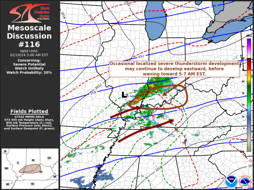
   Mesoscale Discussion 0116
   NWS Storm Prediction Center Norman OK
   0157 AM CST Sat Feb 10 2024

   Areas affected...parts of southern Illinois...southern
   Indiana...western and north central Kentucky

   Concerning...Severe potential...Watch unlikely

   Valid 100757Z - 101000Z

   Probability of Watch Issuance...20 percent

   SUMMARY...Localized strong, to occasionally severe, thunderstorm
   development may persist another hour or two, before tending to wane
   by around 5-7 AM EST.

   DISCUSSION...Isolated vigorous thunderstorm development has been
   maintained for a couple of hours now, probably supported by lift
   associated with enhanced low-level warm advection near a weak
   frontal wave and associated 40 kt 850 mb speed maximum propagating
   across southeastern Missouri into southern Illinois.  It is possible
   that this has been aided by forcing associated with at least a
   couple of speed maxima embedded within broadly anticyclonic flow in
   upper-levels.  While a modest influx of low-level moisture may have
   locally contributed to most unstable CAPE up to around 1000 J/kg,
   latest model output suggests that this destabilization may begin to
   wane during the next couple of hours, perhaps most notably due to
   warming aloft.  Until then (through around 10-12Z), sizable
   clockwise-curved hodographs within the near-surface inflow layer may
   continue to support supercell structures posing a risk for severe
   hail and wind.

   ..Kerr/Guyer.. 02/10/2024

   ...Please see www.spc.noaa.gov for graphic product...

   ATTN...WFO...ILN...LMK...IND...PAH...ILX...

   LAT...LON   37968888 38788742 39018523 38458473 37928495 37718591
               37698672 37738836 37968888
|
|
Top/All Mesoscale Discussions/Forecast Products/Home
|
|


 @NWSSPC