|
| Mesoscale Discussion 621 |
|
< Previous MD Next MD >
|
|
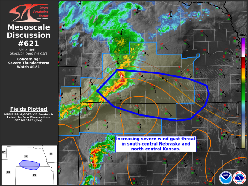
   Mesoscale Discussion 0621
   NWS Storm Prediction Center Norman OK
   0728 PM CDT Fri May 03 2024

   Areas affected...Parts of south-central Nebraska and north-central
   Kansas

   Concerning...Severe Thunderstorm Watch 181...

   Valid 040028Z - 040200Z

   The severe weather threat for Severe Thunderstorm Watch 181
   continues.

   SUMMARY...An organized line of storms could produce 60-75 mph gusts
   as it moves south-southeast.

   DISCUSSION...An organized line segment has developed in western
   Nebraska and moved southeast along  moisture gradient. Measured
   winds of 61 and 63 mph were reported near North Platte. Recent
   surface observations from Holdrege, NE showed the dewpoint jumping
   from 51 to 55 F in the last hour. Other ASOS/KS Mesonet observations
   show upper 50s to low 60s F dewpoints that may try and push
   northwestward this evening. Given the organization of the line and
   the theta-e gradient, this activity will likely continue for the
   next few hours with aid from the low-level jet. The observed 00Z OAX
   and TOP soundings showed capping/low-level drier air making the
   eastward extent of this threat uncertain. Wind gusts of 60-75 mph
   appear possible with this line of storms. Small to marginally severe
   hail may also occur, but should be more isolated given the linear
   mode.

   ..Wendt.. 05/04/2024

   ...Please see www.spc.noaa.gov for graphic product...

   ATTN...WFO...OAX...TOP...GID...LBF...GLD...

   LAT...LON   40320143 40890074 40950071 40859916 40689800 40489735
               40249727 39939741 39559797 39509849 39679983 39900081
               40320143
|
|
Top/All Mesoscale Discussions/Forecast Products/Home
|
|


 @NWSSPC