|
| Mesoscale Discussion 620 |
|
< Previous MD Next MD >
|
|
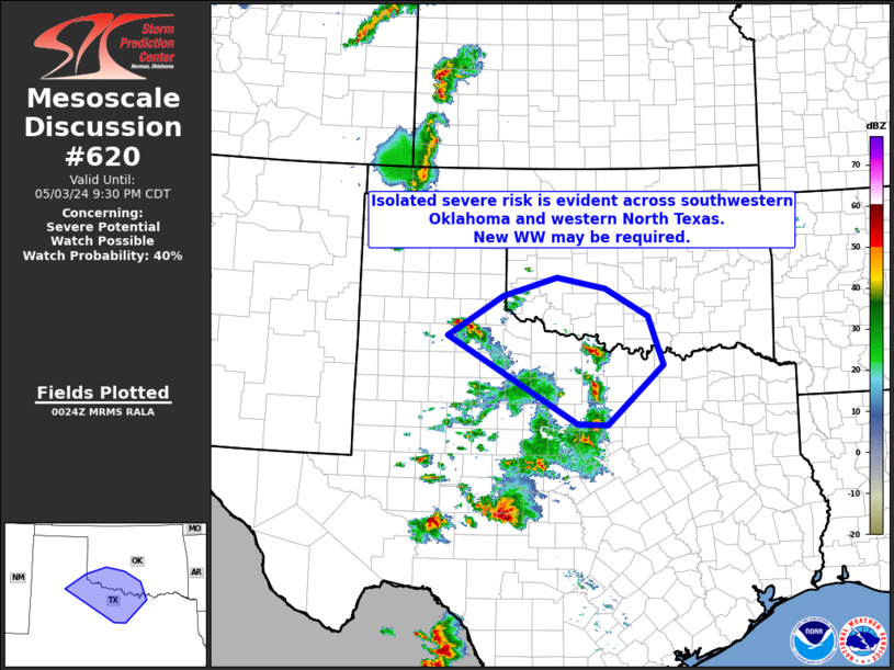
   Mesoscale Discussion 0620
   NWS Storm Prediction Center Norman OK
   0727 PM CDT Fri May 03 2024

   Areas affected...western North Texas into adjacent southwestern
   Oklahoma

   Concerning...Severe potential...Watch possible

   Valid 040027Z - 040230Z

   Probability of Watch Issuance...40 percent

   SUMMARY...Ongoing convection across North Texas -- from west of
   Childress to the Wichita Falls/Jacksboro/Mineral Wells vicinity --
   may expand in coverage/intensity over the next couple of hours.  New
   WW issuance could become necessary, if convection can organize
   further.

   DISCUSSION...A cluster of northeastward-moving storms west of
   Childress will soon exit Tornado Watch 178.  Some model signal is
   evident that the storms could persist -- and even grow upscale a bit
   -- over the next couple of hours.  The currently observed
   environment -- mixed-layer CAPE near or exceeding 3000 J/kg -- would
   certainly support this potential.  While shear remains somewhat
   modest, veering winds with height are providing ample shear for
   mid-level updraft rotation.  Additionally, other storms from near
   Wichita Falls south to near Mineral Wells -- within generally the
   same background environment -- have also maintained intensity.

   We will continue to monitor convective evolution in the short term.
   Signs of increased coverage or upscale growth of this convection
   could warrant WW consideration.

   ..Goss/Guyer.. 05/04/2024

   ...Please see www.spc.noaa.gov for graphic product...

   ATTN...WFO...FWD...OUN...SJT...LUB...AMA...

   LAT...LON   34120118 34810004 35129893 34949794 34469706 33629674
               32589790 32609850 34120118
|
|
Top/All Mesoscale Discussions/Forecast Products/Home
|
|


 @NWSSPC