|
| Mesoscale Discussion 604 |
|
< Previous MD Next MD >
|
|
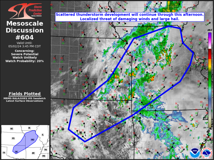
   Mesoscale Discussion 0604
   NWS Storm Prediction Center Norman OK
   0142 PM CDT Thu May 02 2024

   Areas affected...Northern and central OK...southeast KS...and
   central MO

   Concerning...Severe potential...Watch unlikely

   Valid 021842Z - 022045Z

   Probability of Watch Issuance...20 percent

   SUMMARY...Scattered thunderstorm development will continue through
   this afternoon across northern OK, far southeastern KS, and central
   MO. Marginally severe hail up to the size of half dollars (1-1.5
   inches) and localized wind gusts up to 60 mph will be possible with
   any robust updrafts.

   DISCUSSION...Latest visible satellite imagery and surface
   observations show a cold front progressing southward into northern
   OK extending from Lawrence, KS southwestward just through Alva, OK.
   An MCV over far northeastern OK will continue to slowly advance ENE
   this afternoon. Linear forcing along the cold front has resulted in
   enough ascent for a cluster of deep moist convection to develop
   across SE KS. Further northeast across far eastern KS and central
   MO, a few more multicell clusters have developed along a weakly
   forced stationary boundary. As the cold front continues to nudge
   southward into north central OK, additional linear multicell
   clusters will likely develop along it, while more widely scattered
   development persists ahead of the MCV over MO.

   The environment across the region is not particularly favorable for
   supercells given inadequate deep layer shear and low buoyancy
   (widespread cloud cover has persisted through most the day).
   However, as insulation continues to increase this afternoon and a
   slow increase in mid to upper flow spreads eastward, some organized
   updrafts are possible. Convective trends will be monitored for
   intensification.

   ..Barnes/Lyons/Hart.. 05/02/2024

   ...Please see www.spc.noaa.gov for graphic product...

   ATTN...WFO...LSX...DVN...SGF...EAX...TSA...TOP...ICT...OUN...

   LAT...LON   34979734 35539833 36599809 37979605 38279578 39999449
               40589226 40449154 39759141 39249078 38669101 37889165
               36289453 34979734
|
|
Top/All Mesoscale Discussions/Forecast Products/Home
|
|


 @NWSSPC