|
| Mesoscale Discussion 578 |
|
< Previous MD Next MD >
|
|
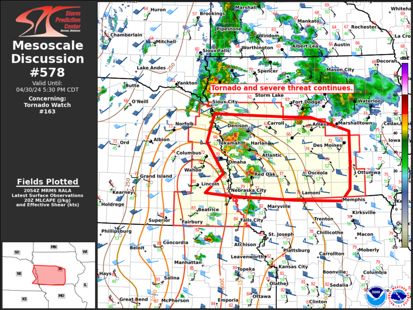
   Mesoscale Discussion 0578
   NWS Storm Prediction Center Norman OK
   0357 PM CDT Tue Apr 30 2024

   Areas affected...Central and western Iowa and far eastern Nebraska

   Concerning...Tornado Watch 163...

   Valid 302057Z - 302230Z

   The severe weather threat for Tornado Watch 163 continues.

   SUMMARY...Tornado and severe threat increasing through late
   afternoon/early evening.

   DISCUSSION...A few discrete supercells continue to mature across
   portions of far western/southwestern Iowa and far eastern Nebraska.
   These storms have developed near a deepening surface cyclone,
   attendant to an upper level shortwave trough, and ahead of a cold
   front within an increasingly unstable air mass. Backed surface flow
   remains in place within the warm sector across central and south
   central Iowa, and the warm front is slowly lifting northward. As a
   mid level jet max around 50-60 kt continues to overspread the
   region, low level shear profiles/hodographs will become even more
   favorable for tornadic supercells. This may especially be true along
   the aforementioned effective warm front where nearly parallel
   effective shear vectors with magnitudes of 55-60 kt will persist
   into early evening.

   ..Barnes/Lyons/Hart.. 04/30/2024

   ...Please see www.spc.noaa.gov for graphic product...

   ATTN...WFO...DMX...EAX...FSD...OAX...

   LAT...LON   40649598 40699653 41099604 41749649 42339629 42309575
               42259424 42259364 41959257 41269256 40759259 40519282
               40529365 40539411 40589479 40599527 40619547 40649598
|
|
Top/All Mesoscale Discussions/Forecast Products/Home
|
|


 @NWSSPC