|
| Mesoscale Discussion 537 |
|
< Previous MD Next MD >
|
|
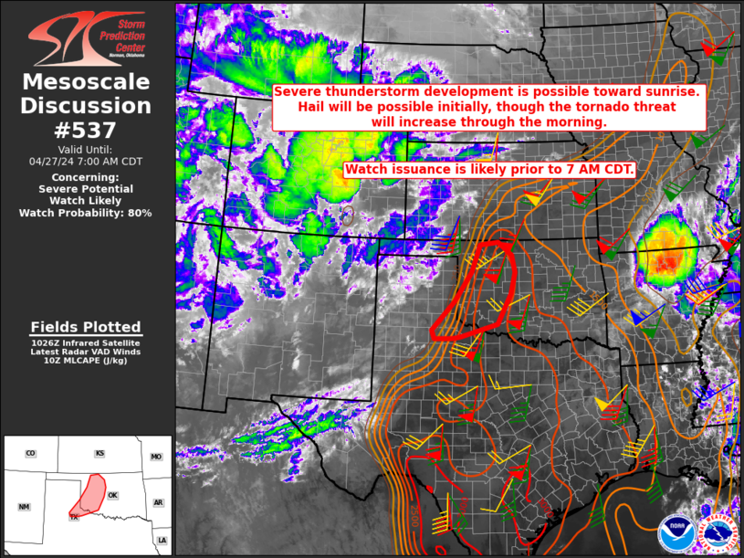
   Mesoscale Discussion 0537
   NWS Storm Prediction Center Norman OK
   0529 AM CDT Sat Apr 27 2024

   Areas affected...Parts of northwest TX into western OK

   Concerning...Severe potential...Watch likely

   Valid 271029Z - 271200Z

   Probability of Watch Issuance...80 percent

   SUMMARY...Severe storm development is possible toward sunrise. Large
   hail will be possible initially, but the tornado threat will
   increase through the morning. Watch issuance is likely prior to 7 AM
   CDT.

   DISCUSSION...Rich low-level moisture is streaming into parts of the
   TX South Plains and northwest TX this morning, in response to a
   strong southerly low-level jet noted on regional VWPs. Meanwhile, a
   strong mid/upper-level shortwave trough and attendant
   mid/upper-level jet are approaching the southern Rockies. A cirrus
   plume now moving over far west TX may be indicative of increasing
   ascent in advance of the shortwave. As this ascent begins to impinge
   on returning moisture across northwest TX, thunderstorm development
   is expected near or just before sunrise, with increasing storm
   coverage expected with time into parts of western OK.

   Initial storm development will likely be somewhat elevated, but
   MUCAPE of greater than 2000 J/kg and strong effective shear will
   support supercell potential with an initial threat of large hail
   (potentially in the 1.5 - 2 inch diameter range). As storms spread
   into western OK, a transition to surface-based convection will be
   possible later this morning, as MLCINH quickly erodes with even
   modest diurnal heating. A transition to one or more clusters is
   possible as storm coverage increases with time this morning, but
   increasingly favorable low-level moisture and wind profiles will
   support embedded supercells with an increasing tornado threat. Watch
   issuance is likely prior to 7 AM CDT.

   ..Dean/Thompson.. 04/27/2024

   ...Please see www.spc.noaa.gov for graphic product...

   ATTN...WFO...OUN...LUB...AMA...

   LAT...LON   34029986 33970016 33960083 34230093 35110009 36019945
               36869914 36939846 36549794 36019782 35349799 34419848
               34029986
|
|
Top/All Mesoscale Discussions/Forecast Products/Home
|
|


 @NWSSPC