|
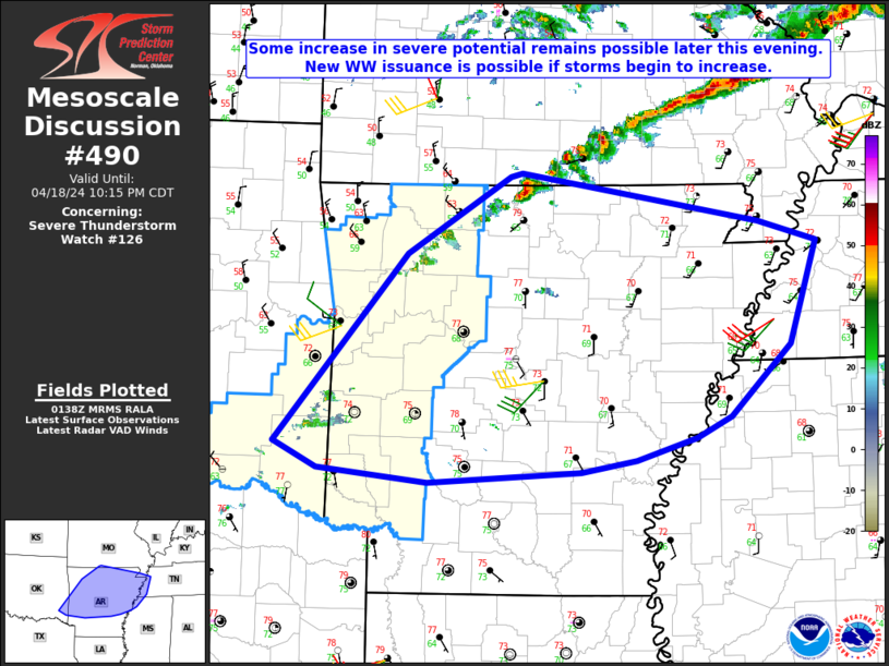
| Mesoscale Discussion 490 |
|
< Previous MD Next MD >
|

|
   Mesoscale Discussion 0490
   NWS Storm Prediction Center Norman OK
   0841 PM CDT Thu Apr 18 2024

   Areas affected...Extreme southeast OK into much of AR...western
   TN...and the MO Bootheel

   Concerning...Severe Thunderstorm Watch 126...

   Valid 190141Z - 190315Z

   The severe weather threat for Severe Thunderstorm Watch 126
   continues.

   SUMMARY...Some increase in severe potential remains possible later
   this evening. New watch issuance is possible if storms begin to
   increase.

   DISCUSSION...Convection has thus far struggled to intensify from
   southeast OK into western AR, likely due to remnant weak capping (as
   noted on the 00Z LZK sounding) and a lack of stronger large-scale
   ascent. However, WV imagery suggests a weak shortwave trough may be
   approaching the region, and a stronger cold frontal surge is
   expected into a larger part of AR later this evening. These factors
   may result in increasing storm coverage with time tonight near the
   front as it moves southeastward.

   Rich low-level moisture (with dewpoints near 70F) beneath modestly
   steep midlevel lapse rates will continue to support MLCAPE in excess
   of 2000 J/kg prior to frontal passage, with deep-layer shear
   remaining sufficient for organized convection. A few stronger
   cells/clusters may evolve with time, with an attendant threat of
   large hail, locally damaging winds, and possibly a tornado. With the
   threat eventually expected to spread eastward and extend beyond the
   expiration time of WW 126, new watch issuance is possible.

   ..Dean/Guyer.. 04/19/2024

   ...Please see www.spc.noaa.gov for graphic product...

   ATTN...WFO...MEG...LZK...SGF...SHV...TSA...

   LAT...LON   34299504 35909367 36579259 36609247 36189001 36008941
               35128970 34519031 34339067 34159130 34059186 33969344
               34079459 34299504
|
|
Top/All Mesoscale Discussions/Forecast Products/Home
|
|


