|
| Mesoscale Discussion 471 |
|
< Previous MD Next MD >
|
|
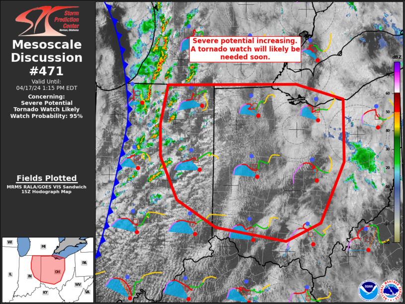
   Mesoscale Discussion 0471
   NWS Storm Prediction Center Norman OK
   1050 AM CDT Wed Apr 17 2024

   Areas affected...portions of eastern IN into central OH

   Concerning...Severe potential...Tornado Watch likely

   Valid 171550Z - 171715Z

   Probability of Watch Issuance...95 percent

   SUMMARY...Severe potential will increase over the next 1-2 hours
   across parts of eastern Indiana into western Ohio. All severe
   hazards will be possible and a tornado watch will likely be needed
   in the next hour.

   DISCUSSION...Heating into the upper 60s to low 70s and dewpoints in
   the low 60s is resulting in modest instability (MLCAPE up to 1000
   J/kg). Effective shear magnitudes greater than 40 kt will support
   organized convection, with supercells and some small line segments
   possible. Damaging gusts to 65 mph and large hail to 1.5 inches in
   diameter will be possible with this activity. Additionally, some
   backing of low-level flow is possible, especially into parts of Ohio
   this afternoon. Forecast and regional VWP data indicates enlarged
   low-level hodographs. Steepening low-level lapse rates and
   increasing 0-3 km MLCAPE with time amid favorable low-level shear
   will support tornado potential in addition to the wind/hail risk. A
   tornado watch will likely be needed within the next hour.

   ..Leitman/Mosier.. 04/17/2024

   ...Please see www.spc.noaa.gov for graphic product...

   ATTN...WFO...PBZ...RLX...CLE...ILN...DTX...IWX...IND...

   LAT...LON   41748587 41768290 41508183 40408183 39358238 39058317
               39298474 39768561 40508601 41078602 41748587
|
|
Top/All Mesoscale Discussions/Forecast Products/Home
|
|


 @NWSSPC