|
| Mesoscale Discussion 470 |
|
< Previous MD Next MD >
|
|
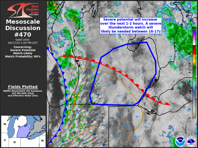
   Mesoscale Discussion 0470
   NWS Storm Prediction Center Norman OK
   1025 AM CDT Wed Apr 17 2024

   Areas affected...portions of Lower Michigan

   Concerning...Severe potential...Watch likely

   Valid 171525Z - 171700Z

   Probability of Watch Issuance...80 percent

   SUMMARY...Severe thunderstorm potential will increase over the next
   couple of hours. Damaging gusts and hail will be the main hazards
   with storms through the afternoon. A severe thunderstorm watch will
   likely be need by 16-17z/12-1pm EDT.

   DISCUSSION...Convection developing near Lake Michigan will shift
   northeast and intensify over the next couple of hours. Surface
   dewpoints have increased into the upper 50s to low 60s F as a warm
   front continues to lift north across southern Lower Michigan.
   Heating of this moistening airmass has aided in weak destabilization
   late this morning, with around 500 J/kg MLCAPE noted in 15z
   mesoanalysis. Effective shear magnitudes around 25-35 kt should
   allow for organized cells or small line segments. Damaging gusts to
   65 mph and hail to 1.5 inches in diameter will be possible with this
   activity through the afternoon. Forecast hodographs and current
   region VWP data indicated modestly enlarged and curved low-level
   hodographs are present. However, instability will remain limited.
   While a tornado can not be entirely ruled out, the prevailing risk
   potential should remain confined to damaging gusts and hail.

   Severe potential will increase from south to northeast with time
   over the next few hours, and severe thunderstorm watch will likely
   be needed for portions of the MCD area.

   ..Leitman/Mosier.. 04/17/2024

   ...Please see www.spc.noaa.gov for graphic product...

   ATTN...WFO...DTX...IWX...GRR...

   LAT...LON   43678462 43848399 43908303 43278264 42828261 42248307
               41838345 41738369 41768512 41788559 42068569 43398518
               43578478 43678462
|
|
Top/All Mesoscale Discussions/Forecast Products/Home
|
|


 @NWSSPC