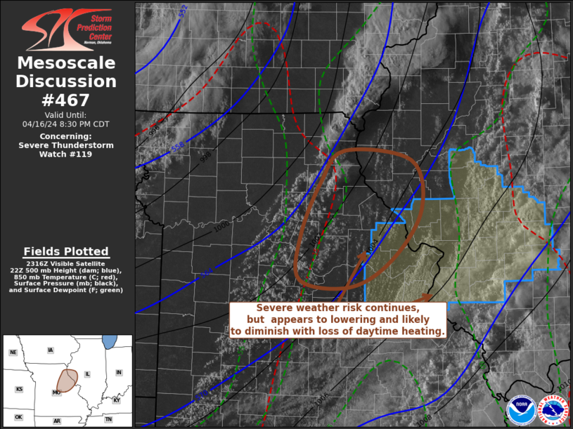
   Mesoscale Discussion 0467
   NWS Storm Prediction Center Norman OK
   0623 PM CDT Tue Apr 16 2024

   Areas affected...Parts of northeast and east central Missouri

   Concerning...Severe Thunderstorm Watch 119...

   Valid 162323Z - 170130Z

   The severe weather threat for Severe Thunderstorm Watch 119
   continues.

   SUMMARY...The risk for widely scattered additional strong to severe
   thunderstorm development near/east of Columbia and Jefferson City
   into areas northwest of St. Louis may still not be negligible.
   However, it appears to be lowering and likely to diminish further
   with the loss of daytime heating.  If current trends continue, the
   watch may be cancelled within the next hour or so.

   DISCUSSION...In the wake of an initial band of weakening convection
   which has spread east of the Mississippi River, a moistening
   low-level environment has contributed to a corridor of increasing
   potential instability across much of northeastern into east central
   and south central Missouri.  This is ahead of a remnant dryline
   advancing across/east of the Kirksville, Columbia and Springfield
   vicinities.

   Renewed discrete thunderstorm development is ongoing as far south as
   areas to the southeast of Kirksville, with additional deepening
   convection noted near/west of Columbia and Jefferson City.  Some
   convection allowing guidance, including the High Resolution Rapid
   Refresh suggest further intensification of the southern convective
   development might still be possible, before spreading near/to the
   northwest of the Greater St. Louis area through 00-02Z.  Based on
   the Rapid Refresh forecast track of a weakening 500 mb jet core, and
   associated mid-level subsidence/warming, this would seem be the
   southern/southeastern limit for stronger convective development.
   However, based on latest water vapor imagery, the potential for new
   storms south of the Hannibal/Quincy area is becoming low.

   ..Kerr.. 04/16/2024

   ...Please see www.spc.noaa.gov for graphic product...

   ATTN...WFO...ILX...LSX...

   LAT...LON   39749206 40139168 40019060 39389045 38759092 38429160
               38519240 39079239 39749206
|


 @NWSSPC