|
| Mesoscale Discussion 465 |
|
< Previous MD Next MD >
|
|
Mesoscale Discussion 0465
NWS Storm Prediction Center Norman OK
0447 PM CDT Tue Apr 16 2024
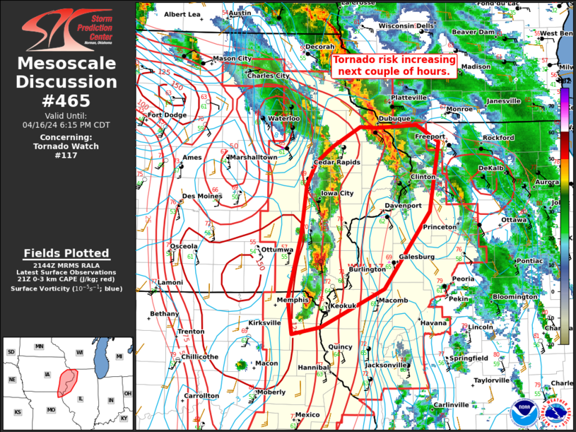
Areas affected...portions of eastern/southeastern Iowa into
northwestern Illinois
Concerning...Tornado Watch 117...
Valid 162147Z - 162315Z
The severe weather threat for Tornado Watch 117 continues.
SUMMARY...The ongoing convective line has evolved into semi-discrete
supercells which will allow for an increase in the risk for all
hazards over the next couple of hours. A favorable
shear/thermodynamic environment may also support a strong (EF-2+)
tornado.
DISCUSSION...As of 2140 UTC, regional radar and satellite data
showed the ongoing convective line in southeastern IA has trended
towards more semi-discrete elements, especially with southward
extent, over the last hour. The broader environment remains
favorable for severe storms with moderate buoyancy and strong
deep-layer shear established. Low-level shear has also increased
ahead of the storms with backed surface flow supporting 300-400
m2/s2 of effective SRH observed from area VADs and SPC mesoanalysis.
With a more supercellular mode emerging, the potential for stronger
mesocyclones within a strong low-level shear environment suggests an
increasing potential for tornadoes, in addition to the continued
risk for damaging winds and hail. STP values of 2-3 along with 0-3km
CAPE of 50-100 J/kg favor strong low-level stretching of vertical
vorticity. Large low-level hodogaphs may also support the risk for a
strong (EF-2+) tornado with the longer lived supercells. This
increasing risk may extended near the Quad Cities and farther east
into parts of northwestern IL over the next couple of hours.
..Lyons.. 04/16/2024
...Please see www.spc.noaa.gov for graphic product...
ATTN...WFO...ILX...LSX...DVN...
LAT...LON 40139192 40529199 41239180 41809172 42069158 42239133
42469092 42449068 42489007 42298974 41508988 40649056
40219150 40139192
|
|
Top/All Mesoscale Discussions/Forecast Products/Home
|
|


 @NWSSPC