|
| Mesoscale Discussion 464 |
|
< Previous MD Next MD >
|
|
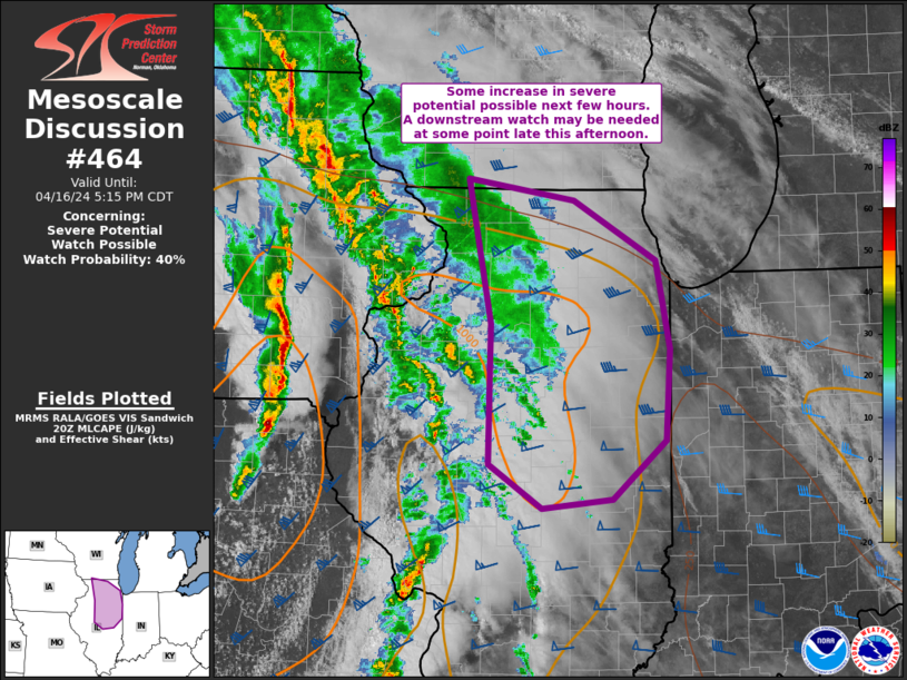
   Mesoscale Discussion 0464
   NWS Storm Prediction Center Norman OK
   0340 PM CDT Tue Apr 16 2024

   Areas affected...portions of northern/central IL

   Concerning...Severe potential...Watch possible

   Valid 162040Z - 162215Z

   Probability of Watch Issuance...40 percent

   SUMMARY...Severe potential may slowly increase over the next few
   hours into parts of northern and central Illinois. A watch may be
   needed at some point late this afternoon, but timing remains
   uncertain.

   DISCUSSION...A band of storms continues to lift northeast across
   eastern IA into western IL this afternoon. Much of the convection is
   somewhat disorganized in a messy storm mode. Downstream into
   northern/central IL, some modest increase in boundary-layer moisture
   still may occur as a warm front lifts north. While strong heating
   has occurred, some weak inhibition remains over parts of the area.
   Nevertheless, modest boundary-layer moisture beneath midlevel lapse
   rates around 7 C/km are supporting weak instability (MLCAPE 1000
   J/kg or less). The initial band of convection moving toward the MCD
   area may largely remain unproductive. However, as large-scale ascent
   increasing toward evening, a secondary band of convection may move
   into the area and post more of a severe risk. Given the somewhat
   limited thermodynamic environment (despite favorable vertical
   shear), severe potential may only gradually increase toward evening.
   The area will be monitored for potential watch issuance, but timing
   is uncertain.

   ..Leitman/Guyer.. 04/16/2024

   ...Please see www.spc.noaa.gov for graphic product...

   ATTN...WFO...LOT...ILX...MKX...DVN...

   LAT...LON   42588989 42398864 41868769 41098752 40288757 39768819
               39688902 40068964 41318962 42588989
|
|
Top/All Mesoscale Discussions/Forecast Products/Home
|
|


 @NWSSPC