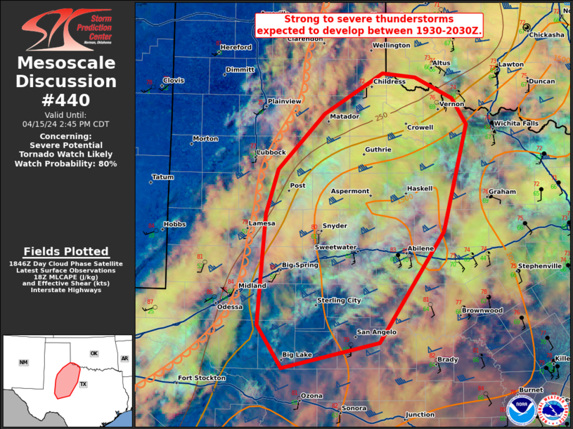
   Mesoscale Discussion 0440
   NWS Storm Prediction Center Norman OK
   0152 PM CDT Mon Apr 15 2024

   Areas affected...Northwest Texas into the Permian Basin

   Concerning...Severe potential...Tornado Watch likely

   Valid 151852Z - 151945Z

   Probability of Watch Issuance...80 percent

   SUMMARY...Strong thunderstorms are expected to develop between 1930Z
   and 2030Z across northwest Texas and vicinity.

   DISCUSSION...Extensive mid and upper-level cloud cover has limited
   heating across northwest Texas for much of the day. However, south
   of these thicker clouds, more substantial heating has occurred with
   temperatures in the mid-to-upper 80s in the Concho Valley. Low-level
   moisture advection also continues across the area with more rich
   moisture arriving earlier this afternoon. This, combined with weak
   cooling aloft, will lead to additional destabilization through the
   afternoon.

   Satellite indicates the environment remains capped, but SPC
   mesoanalysis shows inhibition starting to weaken, a trend which will
   continue over the next 1 to 2 hours. The first wave of ascent can be
   seen on water vapor approaching the New Mexico/Texas border. As this
   overspreads the dryline, localized breaching of the CAP should be
   sufficient for storm development where temperatures have warmed in
   to the mid to upper 80s. This timing matches preferred 12Z CAM
   guidance (NSSL MPAS) and the 17Z WoFS. Moderate to strong
   instability combined with 60+ knots of effective shear will support
   supercells, with an initial threat for large hail (up to baseball
   size) and severe wind gusts (up to 75 mph). However, by later this
   evening, the tornado threat will increase as the low-level jet
   intensifies and STP values increase to 2 to 3 (per 17Z WoFS). A
   tornado watch will be needed in the next 1 to 2 hours.

   ..Bentley/Smith.. 04/15/2024

   ...Please see www.spc.noaa.gov for graphic product...

   ATTN...WFO...OUN...SJT...LUB...MAF...

   LAT...LON   34539958 34580005 34100087 33430152 32900168 31600179
               31090145 31390010 32699919 33979886 34279907 34539958
|


 @NWSSPC