|
| Mesoscale Discussion 332 |
|
< Previous MD Next MD >
|
|
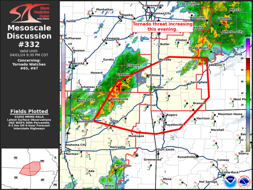
   Mesoscale Discussion 0332
   NWS Storm Prediction Center Norman OK
   0802 PM CDT Mon Apr 01 2024

   Areas affected...northeast Oklahoma...far southeast
   Kansas...southwest Missouri...and far northwest Arkansas.

   Concerning...Tornado Watch 65...67...

   Valid 020102Z - 020230Z

   The severe weather threat for Tornado Watch 65, 67 continues.

   SUMMARY...The tornado threat is increasing across northeast Oklahoma
   into southwest Missouri.

   DISCUSSION...A line of storms with embedded supercells has developed
   from southeast Kansas into northeast Oklahoma. Low-level shear has
   increased substantially since 00Z with 0-1 SRH increasing from 150
   m2/s2 to 250 m2/s2 on the INX VWP. Low-level shear will increase
   further as the low-level jet strengthens to near 50 knots later this
   evening. Therefore, expect the tornado threat to increase as these
   supercells move northeast.

   ..Bentley.. 04/02/2024

   ...Please see www.spc.noaa.gov for graphic product...

   ATTN...WFO...LZK...SGF...TSA...ICT...

   LAT...LON   35909507 36209655 37309575 37979400 37939269 36869264
               35999365 35869444 35909507
|
|
Top/All Mesoscale Discussions/Forecast Products/Home
|
|


 @NWSSPC