|
| Mesoscale Discussion 331 |
|
< Previous MD Next MD >
|
|
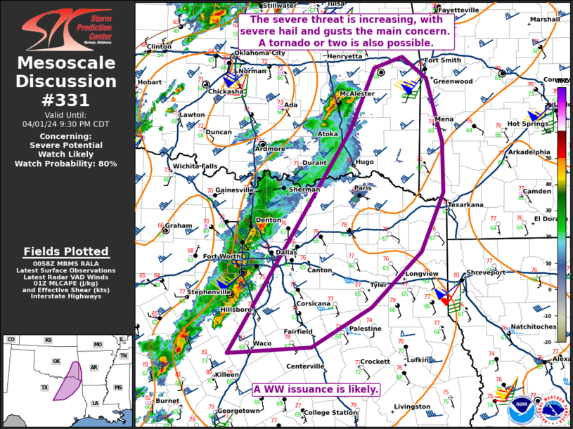
   Mesoscale Discussion 0331
   NWS Storm Prediction Center Norman OK
   0801 PM CDT Mon Apr 01 2024

   Areas affected...portions of eastern Texas into southeastern
   Oklahoma

   Concerning...Severe potential...Watch likely

   Valid 020101Z - 020230Z

   Probability of Watch Issuance...80 percent

   SUMMARY...The severe threat is increasing across portions of
   northeastern Texas into southeastern Oklahoma. Severe hail and wind
   are the main threats, though a tornado cannot be ruled out. A WW
   issuance is likely over the next hour or so.

   DISCUSSION...A QLCS with embedded supercells is progressing across
   the metroplex, with copious amounts of 2-3 inch hail reported with
   the northernmost supercell. These storms are advancing eastward
   across a buoyant warm sector, overspread by 50-70 kts of effective
   bulk shear, so the severe threat is expected to persist with the
   ongoing storms for several more hours. The 00Z FWD observed sounding
   showed 9 C/km mid-level lapse rates and elongated hodographs. As
   such, embedded supercells should continue east of the ongoing
   watches with the potential for severe (50+ kt) gusts and large hail
   (with some 1-2 inch stones possible). Since the storms will be
   approaching the western extent of a low-level jet, a modest increase
   in low-level shear may also support the development of a tornado or
   two. A WW issuance will be needed soon to address the impending
   severe threat.

   ..Squitieri/Hart.. 04/02/2024

   ...Please see www.spc.noaa.gov for graphic product...

   ATTN...WFO...LZK...SHV...TSA...FWD...OUN...

   LAT...LON   31489752 34509559 35359520 35509474 35209434 34359410
               33659408 32869445 32119524 31579619 31489752
|
|
Top/All Mesoscale Discussions/Forecast Products/Home
|
|


 @NWSSPC