|
| Mesoscale Discussion 301 |
|
< Previous MD Next MD >
|
|
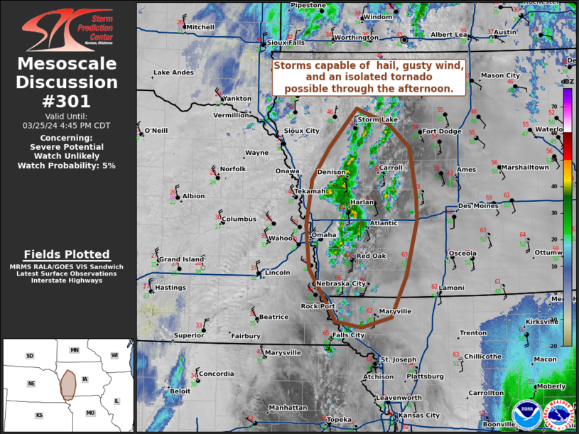
   Mesoscale Discussion 0301
   NWS Storm Prediction Center Norman OK
   0244 PM CDT Mon Mar 25 2024

   Areas affected...southwestern Iowa and far northwestern Missouri

   Concerning...Severe potential...Watch unlikely

   Valid 251944Z - 252145Z

   CORRECTED FOR GRAPHIC

   Probability of Watch Issuance...5 percent

   SUMMARY...Storms capable of hail, gusty wind, and an isolated
   tornado possible through the afternoon.

   DISCUSSION...Low top thunderstorm development has been ongoing near
   the surface low and front across western Iowa into northwestern
   Missouri. Surface observations have shown slow warming and
   moistening of a relatively cool and stable boundary layer through
   the morning, with temperatures now in the upper 50s to mid 60s and
   dew points in the 50s. Though the thermal profile is marginal
   (around 500 J/kg MUCAPE), steep low-level lapse rates around 7-8
   C/km will continue to nose into southern Iowa through the afternoon.
   Given the proximity of the low, steep lapse rates, and modest
   low-level curvature of hodographs, a funnel cloud or isolated
   tornado could be possible. A few instances of gusty winds or hail
   will be possible. A watch is unlikely to be needed at this time.

   ..Thornton/Hart.. 03/25/2024

   ...Please see www.spc.noaa.gov for graphic product...

   ATTN...WFO...DMX...EAX...FSD...OAX...

   LAT...LON   40279553 40919595 41439599 41979591 42369563 42829519
               42649468 42359435 41779425 41489424 40829441 40329464
               40209511 40279553
|
|
Top/All Mesoscale Discussions/Forecast Products/Home
|
|


 @NWSSPC