|
| Mesoscale Discussion 283 |
|
< Previous MD Next MD >
|
|
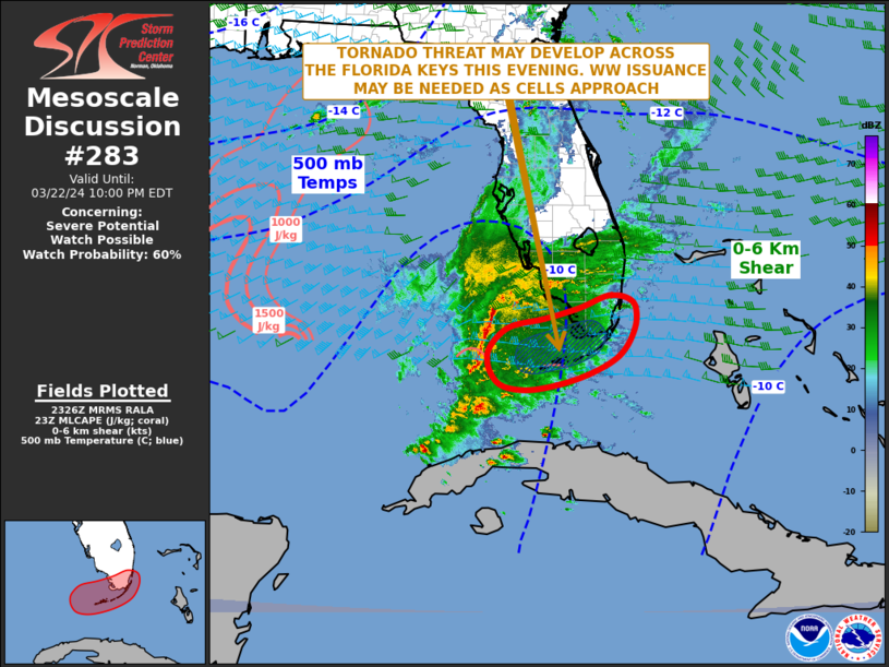
   Mesoscale Discussion 0283
   NWS Storm Prediction Center Norman OK
   0629 PM CDT Fri Mar 22 2024

   Areas affected...Florida Keys...South Florida

   Concerning...Severe potential...Watch possible

   Valid 222329Z - 230200Z

   Probability of Watch Issuance...60 percent

   SUMMARY...A tornado, wind and hail threat may develop over the next
   couple of hours over the Florida Keys and south Florida. Weather
   watch issuance may become necessary this evening.

   DISCUSSION...The latest water vapor imagery and RAP analysis show a
   shortwave trough over the far eastern Gulf of Mexico with a distinct
   vorticity max approaching south Florida. Strong large-scale ascent
   associated with the vorticity max is aiding the development of a
   squall line about 90 statute miles to the west of Key West. Ahead of
   this line, surface dewpoints are in the lower 70s F across the
   Florida Keys. Temperatures in the upper 70s F are yielding MLCAPE in
   the 600 to 800 J/kg range according to the RAP. The WSR-88D VWP at
   Key West is impressive with 0-6 km shear near 65 knots, 0-3 km
   storm-relative helicity around 300 m2/s2, and a clockwise curved
   hodograph. This will likely support a severe threat, as a
   squall-line approaches and then moves across the Florida Keys this
   evening. A tornado threat will be possible with the stronger cells
   embedded in the line, and with supercells if discrete cells can
   develop ahead of the line. A wind-damage and isolated large hail
   threat is also expected to accompany the squall-line as it moves
   across the Florida Keys, most likely during the 02Z and 05Z
   timeframe.

   ..Broyles/Guyer.. 03/22/2024

   ...Please see www.spc.noaa.gov for graphic product...

   ATTN...WFO...MFL...KEY...

   LAT...LON   25888002 25938032 25878053 25688099 25498171 25338241
               25078276 24788290 24458283 24208256 24148191 24388096
               24768019 25287985 25717983 25888002
|
|
Top/All Mesoscale Discussions/Forecast Products/Home
|
|


 @NWSSPC