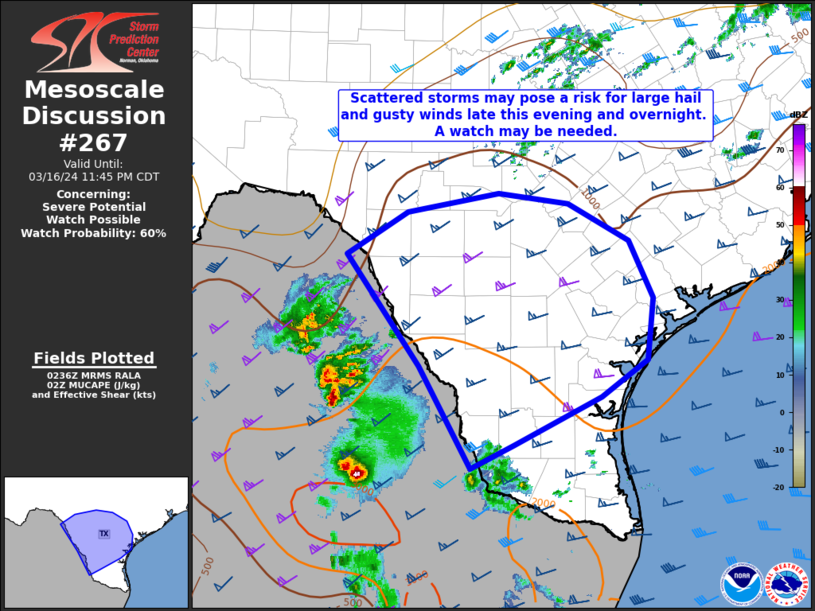
   Mesoscale Discussion 0267
   NWS Storm Prediction Center Norman OK
   0939 PM CDT Sat Mar 16 2024

   Areas affected...parts of south Texas

   Concerning...Severe potential...Watch possible

   Valid 170239Z - 170445Z

   Probability of Watch Issuance...60 percent

   SUMMARY...Scattered storms are expected across parts of south Texas
   late this evening, some of which may produce hail and gusty winds. A
   watch may be issued.

   DISCUSSION...Thunderstorms are ongoing in northeast Mexico in
   advance of a subtle shortwave trough apparent in water vapor
   satellite imagery. Across south Texas, some nocturnal surface
   stabilization has occurred. However, an ACARS profile from San
   Antonio and regional RAP profiles indicate the presence of a deep
   moist layer, which should continue to support convection even in the
   presence of a surface stable layer. Given diffuse low-level forcing
   for ascent, storms are expected to remain cellular, though some
   clustering is apparent in short-term model guidance. In addition,
   with deep CAPE profiles and relatively steep mid-level lapse rates
   along with long, straight hodographs (effective bulk shear values of
   50-60 kts), large hail is expected to be the primary threat.
   Additionally, some gusty winds are possible with any clustering that
   occurs, though this is mitigated by the relatively moist profile.
   Short-term model guidance indicates storms will continue eastward
   across south Texas through the night before moving off the coast
   early in the morning.

   ..Supinie/Goss.. 03/17/2024

   ...Please see www.spc.noaa.gov for graphic product...

   ATTN...WFO...CRP...EWX...BRO...

   LAT...LON   27829998 29110093 29600014 29819895 29699805 29269725
               28619694 27899703 27489763 26929876 26659932 27829998
|


 @NWSSPC