|
| Mesoscale Discussion 194 |
|
< Previous MD Next MD >
|
|
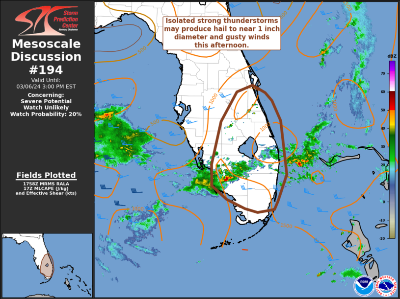
   Mesoscale Discussion 0194
   NWS Storm Prediction Center Norman OK
   1201 PM CST Wed Mar 06 2024

   Areas affected...central/southern Florida Peninsula

   Concerning...Severe potential...Watch unlikely

   Valid 061801Z - 062000Z

   Probability of Watch Issuance...20 percent

   SUMMARY...Thunderstorm activity is expected to increase over the
   next couple of hours. Isolated strong storms may produce hail near a
   half inch to 1 inch in diameter and gusty winds. A watch is not
   currently expected.

   DISCUSSION...Thunderstorms along the southwest coast of the FL
   Peninsula have increased in intensity over the past 30 minutes or
   so. This activity is moving east along a weak differential heating
   zone created by early clouds and morning showers, and within a zone
   of weak low-level convergence. Despite scattered clouds across the
   central/southern Peninsula, dewpoints mostly in the upper 60s to
   near 70 F and modest midlevel lapse rates has allowed MLCAPE values
   to increase to around 1000-1500 J/kg. A 17z RAOB from MFL does
   indicated some weak inhibition in the 500-1500 m layer, though ample
   elevated instability is noted. Additional heating increasing ascent
   through the afternoon should largely mitigate inhibition.

   Vertical shear will remain somewhat marginal, around 25-35 kt, but
   sufficient for at least transient/short-lived strong/organized
   updrafts. Hail approaching 1 inch in diameter and gusty winds will
   be the main hazards with isolated thunderstorm activity through
   23-00z. Low-level winds are fairly weak, especially through 1 km.
   However, some favorable curvature to low-level hodograph (per 17z
   MFL RAOB and region radar VWPs) and effective SRH around 100 m2/s2
   amid a very moist low-level airmass could support a brief/weak
   spin-up near the southeast coast where better low-level convergence
   is noted. Overall, severe potential is expected to remain marginal
   and sporadic, and a watch is not expected at this time.

   ..Leitman/Hart.. 03/06/2024

   ...Please see www.spc.noaa.gov for graphic product...

   ATTN...WFO...MFL...MLB...TBW...

   LAT...LON   25668008 25488016 25468029 25418060 25498093 25728141
               26038180 26558182 27568158 28288116 28448073 28258039
               28078021 27597998 26317984 25668008
|
|
Top/All Mesoscale Discussions/Forecast Products/Home
|
|


 @NWSSPC