Mesoscale Discussion 0174
NWS Storm Prediction Center Norman OK
0508 AM CST Wed Feb 28 2024
Areas affected...Ohio..Western West Virginia...Central and Eastern
Kentucky
Concerning...Tornado Watch 28...29...
Valid 281108Z - 281315Z
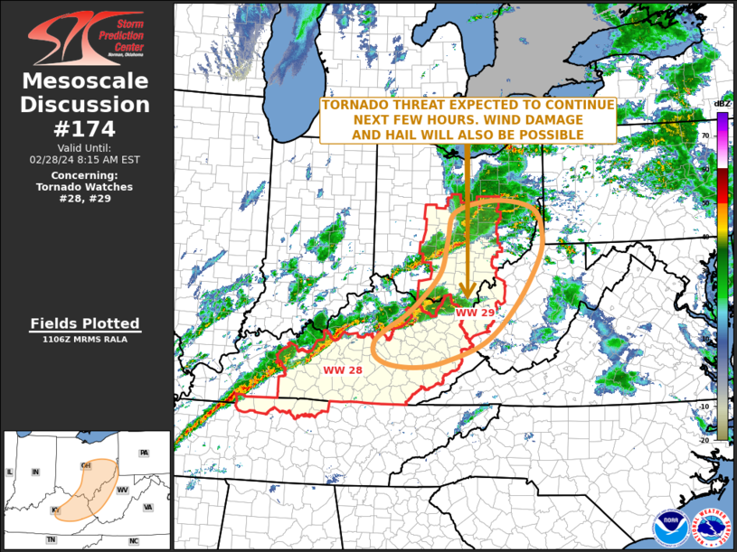
The severe weather threat for Tornado Watch 28, 29 continues.
SUMMARY...A tornado threat is expected to continue over the next few
hours across parts of central and eastern Kentucky northward into
southeast Ohio. Weather watch issuance or a watch extension in area
may need to be considered to the east of the current watches.
DISCUSSION...The latest high-resolution radar imagery from
Wilmington, Ohio has a more extensive line segment in central and
southern Ohio, containing multiple bowing structures. A tornado was
recently reported with a bowing segment to the west of Columbus,
Ohio. This part of the northern line is now located to the east of
Columbus, and is expected to continue to have a tornado threat over
the next hour or two. The severe threat, including a potential for
hail and wind damage, may continue after daybreak.
Further south in parts of central and eastern Kentucky,
high-resolution radar shows a line of strong to severe storms from
near Vanceburg, Kentucky southwestward to near Lexington. Strong to
severe short bowing structures are evident within the line, with
some supercells also present. This line is expected to continue to
hold together as it moves eastward across the remainder of eastern
Kentucky this morning. The strong low-level shear will likely
support an isolated tornado threat. Hail and isolated damaging winds
will also be possible.
..Broyles.. 02/28/2024
...Please see www.spc.noaa.gov for graphic product...
ATTN...WFO...PBZ...RLX...CLE...JKL...ILN...LMK...
LAT...LON 40358275 40588175 40438080 39958056 39418067 38528124
37818199 37438299 37328369 37378438 37548473 37838474
38078441 38428386 39128315 39808295 40358275
|


 @NWSSPC