|
| Mesoscale Discussion 172 |
|
< Previous MD Next MD >
|
|
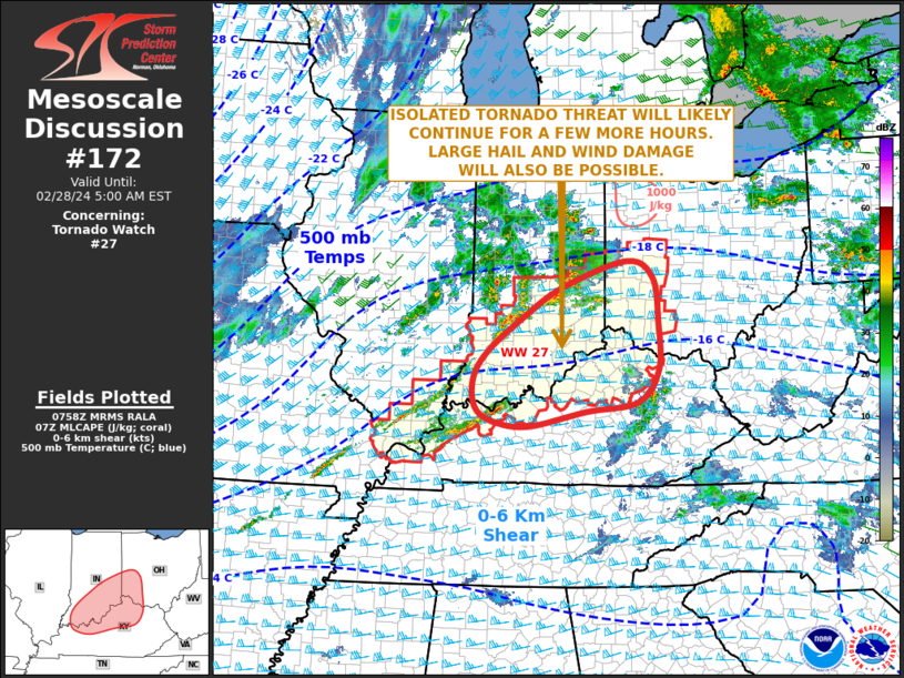
   Mesoscale Discussion 0172
   NWS Storm Prediction Center Norman OK
   0201 AM CST Wed Feb 28 2024

   Areas affected...Southern Indiana...Southwest Ohio...Northern
   Kentucky

   Concerning...Tornado Watch 27...

   Valid 280801Z - 281000Z

   The severe weather threat for Tornado Watch 27 continues.

   SUMMARY...A tornado threat is expected to continue across WW 27 for
   a few more hours. Isolated large hail and wind damage will also be
   possible.

   DISCUSSION...The latest high-resolution radar imagery shows a couple
   strong to severe short line segments over southern Indiana. This
   convection is located along a corridor of instability, where the RAP
   is estimating MLCAPE in the 500 to 1000 J/kg range. Water vapor
   imagery and 500 mb analysis from the RAP have a shortwave trough and
   fast moving vorticity max located in southwest Indiana. This feature
   will continue to enhance lift and provide support for continued
   strong thunderstorm development early this morning. The latest
   WSR-88D VWP from Indianapolis has 0-6 km shear near 55 knots
   suggesting that supercells with large hail and wind damage will be
   possible. In addition, a 60 to 70 knot jet is analyzed at 850 mb
   centered over far northern Kentucky which will continue to provide
   strong low-level shear sufficient for an isolated tornado threat.
   Furthermore, an increase in the severe threat could occur over the
   next few hours in northern Kentucky as cells increase in coverage
   within and just to the south of WW 27.

   ..Broyles.. 02/28/2024

   ...Please see www.spc.noaa.gov for graphic product...

   ATTN...WFO...JKL...ILN...LMK...IND...PAH...

   LAT...LON   38318748 38748719 39278649 39768569 40188437 39928382
               39188372 38458371 37938413 37788519 37548639 37638711
               37868745 38318748
|
|
Top/All Mesoscale Discussions/Forecast Products/Home
|
|


 @NWSSPC