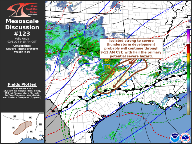
   Mesoscale Discussion 0123
   NWS Storm Prediction Center Norman OK
   0640 AM CST Sun Feb 11 2024

   Areas affected...parts of eastern Texas into southwestern Arkansas
   and northwestern Louisiana

   Concerning...Severe Thunderstorm Watch 16...

   Valid 111240Z - 111515Z

   The severe weather threat for Severe Thunderstorm Watch 16
   continues.

   SUMMARY...Isolated strong to severe thunderstorm development may
   continue through 9-11 AM CST, with hail remaining the primary
   potential severe hazard.

   DISCUSSION...An initial area of stronger large-scale ascent appears
   to be pivoting north of the Red River Valley.  However, one
   persistent strong cell/small cluster of convective development
   continues to be supported by a focused area of enhanced
   lower/mid-tropospheric warm advection now spreading across the
   Tyler, TX toward Shreveport, LA vicinities.  Based on latest model
   output, it remains unclear how much longer this will be maintained,
   but sustained weakening trends have yet to develop, and it is on
   track to reach the Shreveport vicinity by 15Z.

   Otherwise, into the 15-17Z time frame, weaker low-level warm
   advection appears likely to persist within a corridor north of the
   upper Texas coastal plain through the Shreveport vicinity, beneath
   at least weakly difluent high-level low.  This may support
   continuing convective development, with the stronger thunderstorm
   development perhaps shifting closer to the surface frontal zone,
   near the Huntsville vicinity.

   ..Kerr.. 02/11/2024

   ...Please see www.spc.noaa.gov for graphic product...

   ATTN...WFO...LZK...SHV...HGX...FWD...

   LAT...LON   32069587 32609543 33099443 33429288 32619231 32119346
               30709551 30469650 30829711 31349651 32069587
|


 @NWSSPC