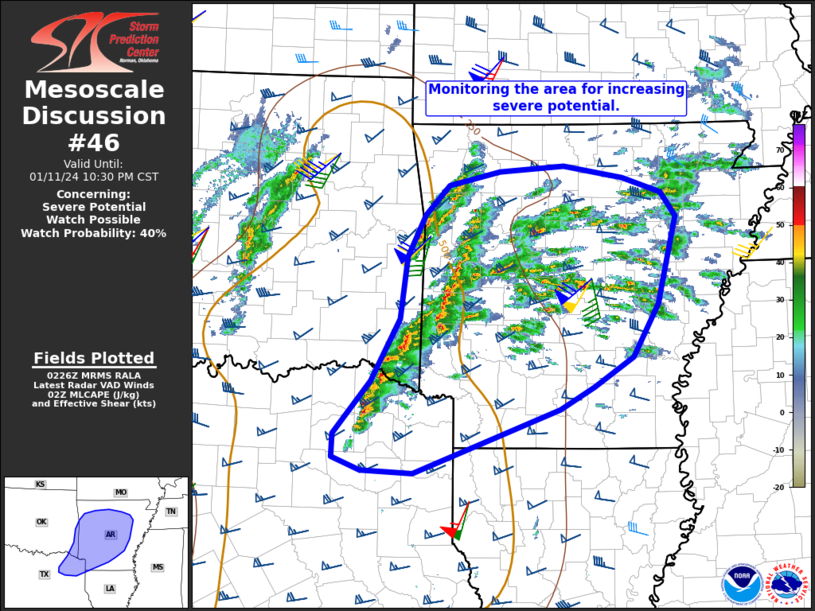
   Mesoscale Discussion 0046
   NWS Storm Prediction Center Norman OK
   0828 PM CST Thu Jan 11 2024

   Areas affected...Northeast TX...southeast OK...and much of AR

   Concerning...Severe potential...Watch possible

   Valid 120228Z - 120430Z

   Probability of Watch Issuance...40 percent

   SUMMARY...The area is being monitored for an initial round of strong
   to severe thunderstorms, with the primary risks being large hail and
   damaging winds.

   DISCUSSION...Thunderstorms are increasing in coverage across parts
   of southeast OK, northeast TX, and much of AR this evening, largely
   aided by strengthening low-level warm advection evident in regional
   VWP data and observed 00Z soundings. Per the observed LZK 00Z
   sounding and RAP forecast soundings, storms evolving over central AR
   are likely elevated, though 50-60 kt of effective shear and a plume
   of steep lapse rates overspreading the region are supporting loosely
   organized storm structures with occasional midlevel rotation. The
   primary concern with this activity will be sporadic marginally
   severe hail, though localized clustering could support damaging
   winds as well.

   Farther southwest in northeast TX and southeast OK, a broken band of
   thunderstorms is evolving where low-level convergence is slightly
   stronger ahead of an evolving surface low in OK. Lower 60s dewpoints
   are gradually spreading north ahead of these storms (beneath steeper
   midlevel lapse rates), suggesting that an evolution to surface-based
   convection is possible. Similarly strong deep-layer shear will favor
   embedded supercell structures (with an attendant risk of large hail
   and damaging winds). However, if this activity can root at the
   surface, large clockwise-curved hodographs with strong streamwise
   vorticity could conditionally support a tornado or two.

   Overall, the need for a watch in the short-term is uncertain, though
   trends are being monitored. A second round of severe storms is
   expected along the cold front later tonight.

   ..Weinman/Goss.. 01/12/2024

   ...Please see www.spc.noaa.gov for graphic product...

   ATTN...WFO...LZK...SHV...TSA...FWD...

   LAT...LON   33169558 33739511 34399474 35069465 35529441 35849411
               35999344 36049260 35919183 35769133 35509114 34559138
               33999171 33669222 33439266 32749456 32769522 32919560
               33169558
|


 @NWSSPC