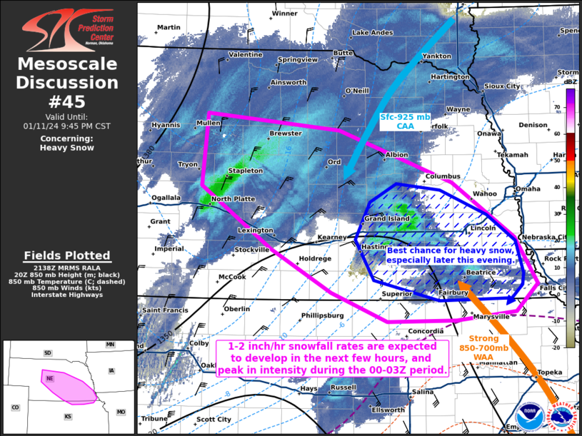
   Mesoscale Discussion 0045
   NWS Storm Prediction Center Norman OK
   0340 PM CST Thu Jan 11 2024

   Areas affected...portions of central and southeastern Nebraska into
   extreme northern Kansas

   Concerning...Heavy snow

   Valid 112140Z - 120345Z

   SUMMARY...Heavy snow should increase into the evening hours, with
   1-2 inch/hr rates possible. Heavy snow will be most likely in
   central Nebraska over the next couple of hours, becoming
   increasingly likely in southeast Nebraska in the 00-03Z period.

   DISCUSSION...A pronounced mid-level trough is ejecting into the
   Plains states, with a 120+ kt 300 mb jet streak overspreading the
   southern Plains. This places the central Plains in the left-exit
   region of the upper-jet (per 21Z mesoanalysis), resulting in plenty
   of divergence aloft. The low-level mass response has been for the
   surface low to intensify across the southern Plains. This supports
   an increase in surface-925 mb cold air advection beneath increasing
   intense 850-700 mb warm-air advection over central and eastern NE,
   where 700 mb frontogenesis is also now underway. Moderate snow has
   recently begun to fall in central Nebraska per surface observations,
   with snowfall rates expected to only increase with time as dynamic
   lift increases and the dendritic growth zone continues to saturate.

   Later this afternoon, the anticipated heavier snow bands may produce
   snowfall rates up to 1-2 inches/hour, where reduced visibility will
   also become a concern. Latest high-resolution model guidance
   consensus suggests that the heaviest snow should begin in the next
   couple of hours, and peak in intensity somewhere in the 00-03Z
   period, especially over southeastern NE.

   ..Squitieri.. 01/11/2024

   ...Please see www.spc.noaa.gov for graphic product...

   ATTN...WFO...OAX...TOP...GID...LBF...

   LAT...LON   42230081 42039872 41419693 40749594 40189559 39849594
               39749687 39739796 40089884 40609979 41350089 42230081
|


 @NWSSPC