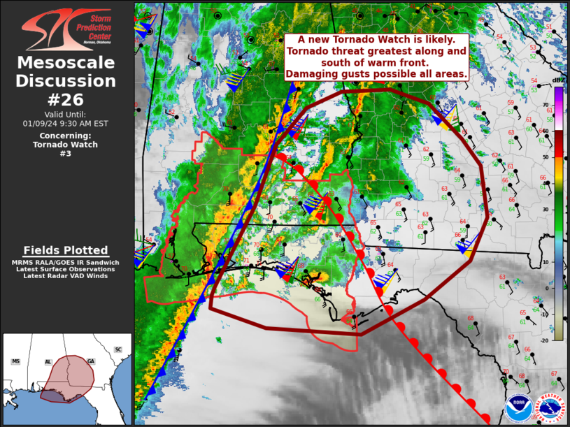
   Mesoscale Discussion 0026
   NWS Storm Prediction Center Norman OK
   0536 AM CST Tue Jan 09 2024

   Areas affected...the Florida Panhandle...southern Alabama...and
   southwest Georgia

   Concerning...Tornado Watch 3...

   Valid 091136Z - 091430Z

   The severe weather threat for Tornado Watch 3 continues.

   SUMMARY...The threat for supercells producing tornadoes and severe
   wind persists across eastern parts of Tornado Watch 3, with an
   additional watch likely for areas east/northeast prior to 13Z.

   DISCUSSION...A small but volatile warm sector currently exists
   across the FL Panhandle, and this air mass will likely spread into
   parts of southern AL and southwest GA later this morning. Shear
   remains extreme with 0-1 km SRH values between 500-600 m2/s2, which
   is also coincident with the warm front. This boundary is forecast to
   move north, though progression may be slow due to ongoing
   precipitation.

   The supercell near Holmes County FL is likely right on the warm
   front. Depending on boundary motion, a tornado risk may remain for a
   short time prior to the storm moving over the cooler air to the
   north. Farther south, an impressive supercell, likely tornadic and
   producing hail, is now moving into Bay County from the Gulf Of
   Mexico. These cells, as well as any additional cells that form ahead
   of the cold front/squall line, could result in strong tornadoes.

   ..Jewell.. 01/09/2024

   ...Please see www.spc.noaa.gov for graphic product...

   ATTN...WFO...JAX...FFC...TAE...BMX...MOB...

   LAT...LON   30138723 31258662 32118629 32628581 32858523 32888442
               32698380 32198325 31818295 31088286 30498316 29968389
               29488490 29568641 29828731 30008728 30138723
|


 @NWSSPC