|
| Mesoscale Discussion 17 |
|
< Previous MD Next MD >
|
|
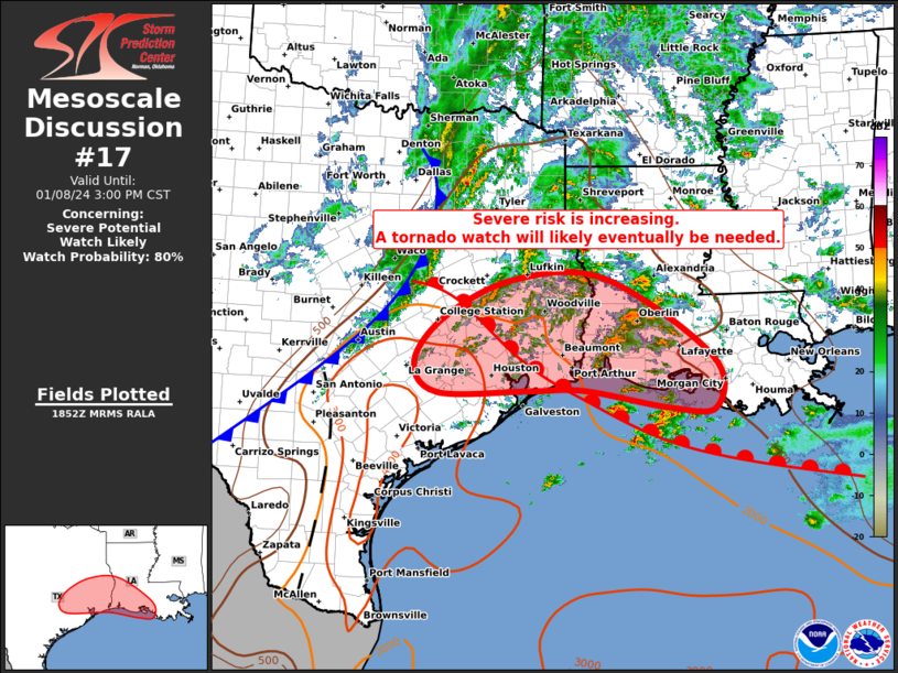
   Mesoscale Discussion 0017
   NWS Storm Prediction Center Norman OK
   1254 PM CST Mon Jan 08 2024

   Areas affected...Southeast Texas...Southwest Louisiana

   Concerning...Severe potential...Watch likely

   Valid 081854Z - 082100Z

   Probability of Watch Issuance...80 percent

   SUMMARY...Thunderstorms are continuing to slowly intensify, with the
   issuance of a tornado watch likely in the next 1-3 hours.

   DISCUSSION...Scattered thunderstorms continue to intensify across
   parts of east TX and western LA, mainly along and north of a surface
   warm front that extends from north of HOU to east of ACT.  To the
   south of the front, surface dewpoints have risen into the mid/upper
   60s, with MLCAPE values of 2000-3000 J/kg.  VAD profiles near the
   warm front show very strong low-level vertical shear with 0-3km SRH
   values of 500 and 900 m2/s2 at HGX and LCH.

   Thus far, thunderstorms have been elevated with primarily a large
   hail threat.  Recent CAM solutions suggest that continued daytime
   heating will begin to aid convective development along the immediate
   warm front to the west of HOU in the next couple of hours, which
   would potentially have a greater risk of surface-based supercells
   and an attendant threat of tornadoes - along with large hail and
   damaging winds.  This area is being closely monitored for convective
   development and potential tornado watch issuance.

   ..Hart/Gleason.. 01/08/2024

   ...Please see www.spc.noaa.gov for graphic product...

   ATTN...WFO...LCH...SHV...HGX...EWX...

   LAT...LON   30659619 31249496 31269332 30059141 29259136 29269219
               29529371 29529471 29489630 29729692 30659619
|
|
Top/All Mesoscale Discussions/Forecast Products/Home
|
|


 @NWSSPC