|
| Mesoscale Discussion 16 |
|
< Previous MD Next MD >
|
|
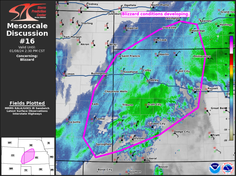
   Mesoscale Discussion 0016
   NWS Storm Prediction Center Norman OK
   1035 AM CST Mon Jan 08 2024

   Areas affected...Portions of eastern Colorado...western Kansas and
   southern Nebraska.

   Concerning...Blizzard

   Valid 081635Z - 082030Z

   SUMMARY...Blizzard conditions have started to develop across western
   Kansas. These conditions will expand to portions of eastern Colorado
   and into southern Nebraska this afternoon.

   DISCUSSION...Northerly flow has started to strengthen across western
   Kansas in response to the deepening 850mb low near the TX/OK
   Panhandle. Some of this stronger flow has started to mix to the
   surface within the snow band across western Kansas. This has
   resulted in sustained winds of 25 to 30 knots across southwest
   Kansas. Expect winds to strengthen further through the afternoon as
   the cyclone continues to amplify. In addition, these winds will more
   efficiently mix to the surface through the day as cold air advection
   strengthens in the region.

   As colder air filters into the area, snow ratios will increase and
   visibility restrictions from blowing snow will likely increase which
   is expected to further exacerbate blizzard conditions late this
   afternoon and into this evening.

   ..Bentley.. 01/08/2024

   ...Please see www.spc.noaa.gov for graphic product...

   ATTN...WFO...ICT...GID...LBF...DDC...GLD...PUB...

   LAT...LON   39880187 40520046 40749972 40659916 39849887 38439916
               37730046 37290177 37110258 37630301 38880269 39840193
               39880187
|
|
Top/All Mesoscale Discussions/Forecast Products/Home
|
|


 @NWSSPC