Mesoscale Discussion 2085
NWS Storm Prediction Center Norman OK
1034 AM CST Thu Dec 30 2021
Areas affected...portions of western Alabama into central Georgia
Concerning...Severe potential...Watch possible
Valid 301634Z - 301830Z
Probability of Watch Issuance...40 percent
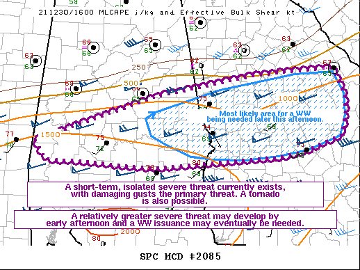
SUMMARY...A gradual uptick in severe potential is possible into the
early afternoon hours. Damaging gusts would be the primary severe
threat, though a tornado or two is also possible. A WW issuance may
eventually be needed over the next couple of hours.
DISCUSSION...Multiple discrete/semi-discrete west-east progressing
storms have been moving roughly parallel to a southward-sagging
surface cold front over the past couple of hours. In the past hour,
some of these storms have deviated to the right slightly, with KBMX
and MRMS mosaic radar showing modest low and mid-level rotation with
storms in central AL. Surface temperatures ahead of these storms are
at least in the mid 70s F, with near 70 F dewpoints, contributing to
1000 J/kg MLCAPE given 6-6.5 C/km mid-level lapse rates (per 16Z
mesoanalysis). Though parallel to the surface cold front, 50 kts of
effective bulk shear suggests that potential exists for the more
intense, sustained updrafts to become or remain organized.
While overall deep-layer ascent is weak, ample diurnal heating ahead
of these storms may foster enough lift and buoyancy to pose a severe
threat. Given veered low-level wind profiles (evident via recent MXX
and JGX VWPs), damaging gusts are anticipated to be the primary
threat, though a tornado also cannot be ruled out given nearly 150
m2/s2 0-1 km SRH. The main question is when the bulk of the severe
threat will occur. A sparse severe threat exists at present.
However, since the uptick in severe may be gradual, a WW may not be
needed for at least a few more hours. Convective trends will
continue to be monitored for the need of a WW issuance.
..Squitieri/Goss/Hart.. 12/30/2021
...Please see www.spc.noaa.gov for graphic product...
ATTN...WFO...CAE...FFC...BMX...MOB...
LAT...LON 32348836 33118602 33458405 33538258 33468252 33078234
32768234 32428243 32388258 32188317 32108368 31948609
32038744 32058816 32348836
|


 @NWSSPC