|
| Mesoscale Discussion 1873 |
|
< Previous MD Next MD >
|
|
Mesoscale Discussion 1873
NWS Storm Prediction Center Norman OK
0213 PM CDT Sat Oct 16 2021
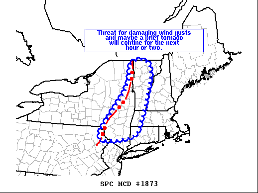
Areas affected...Eastern NY...Much of VT...Far Western MA...Far
Western CT
Concerning...Severe Thunderstorm Watch 529...
Valid 161913Z - 162030Z
CORRECTED FOR INCORRECT GEOGRAPHIC DESCRIPTION IN AREAS AFFECTED
The severe weather threat for Severe Thunderstorm Watch 529
continues.
SUMMARY...Threat for damaging wind gusts and maybe a brief tornado
will continue across the region for the next hour or two.
DISCUSSION...Shallow convective line extending from the northernmost
NY/VT border to the NY Hudson Valley continues to move
east-northeastward at about 30-35 kt. Only modest changes in the
thermodynamic environment preceding the line have occurred over the
past hour or so, with much of the area still characterized by
temperatures in the mid/upper 70s and dewpoints in the low/mid 60s.
A pocket of somewhat higher low-level moisture exists across far
northern VT, where mesoanalysis estimated MLCAPE is around 500 J/kg.
Additionally, the wind profile across the region remains supportive
of low-level rotation, particularly across northern VT. Recent VAD
from CXX sampled over 350 m2/s2 of 0-1 km storm-relative helicity
and over 500 m2/s2 of 0-3 km storm-relative helicity. These
conditions suggest the threat for damaging wind gusts and maybe even
a brief tornado will continue for the next hour or two before
limited instability likely leads to a diminished threat across New
England.
..Mosier.. 10/16/2021
...Please see www.spc.noaa.gov for graphic product...
ATTN...WFO...BOX...BTV...OKX...ALY...BGM...
LAT...LON 42127506 43137423 43787377 44507356 44797362 44997319
44977252 44297228 42247291 41597341 41437527 42127506
|
|
Top/All Mesoscale Discussions/Forecast Products/Home
|
|


 @NWSSPC