|
| Mesoscale Discussion 1872 |
|
< Previous MD Next MD >
|
|
Mesoscale Discussion 1872
NWS Storm Prediction Center Norman OK
1250 PM CDT Sat Oct 16 2021
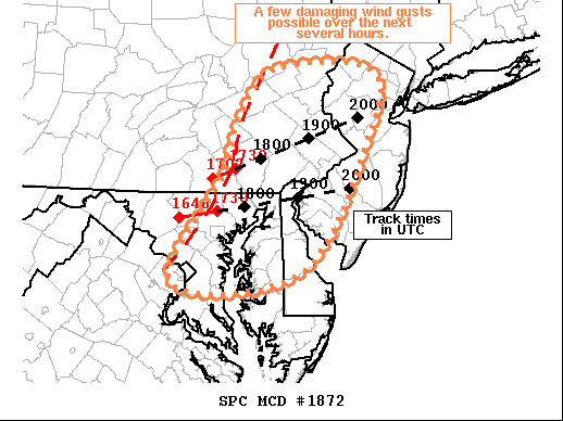
Areas affected...Southeastern PA...Eastern MD...NJ...DE
Concerning...Severe potential...Watch possible
Valid 161750Z - 161945Z
Probability of Watch Issuance...40 percent
SUMMARY...Line of showers and thunderstorms moving into eastern
PA/MD may produce a few damaging wind gusts as it continues eastward
over the next few hours.
DISCUSSION...A modest increase in reflectivity has been noted within
the showers/deeper convection along the leading edge of the cold
front moving through the region over the past half hour or so. The
downstream air mass has heated into the upper 70s/low 80s amid mid
60s dewpoints. As a result, a modest increase in buoyancy has
occurred, with mesoanalysis estimated MLCAPE around 250 J/kg from
eastern MD northward to the northern PA/NJ border vicinity. This
region is displaced south of the better forcing for ascent and
stronger flow aloft. However, enhanced low-level flow (sampled well
by the DOX and DIX VAD profiles) still appears strong enough to
support a damaging wind threat with any deeper, more persistent
cells. Uncertainty regarding overall coverage of strong storms
precludes higher watch probability, but convective trends will be
monitored closely.
..Mosier/Grams.. 10/16/2021
...Please see www.spc.noaa.gov for graphic product...
ATTN...WFO...PHI...BGM...CTP...LWX...
LAT...LON 40487634 41027584 41027453 40397453 38917547 38777721
39907655 40487634
|
|
Top/All Mesoscale Discussions/Forecast Products/Home
|
|


 @NWSSPC