|
| Mesoscale Discussion 1871 |
|
< Previous MD Next MD >
|
|
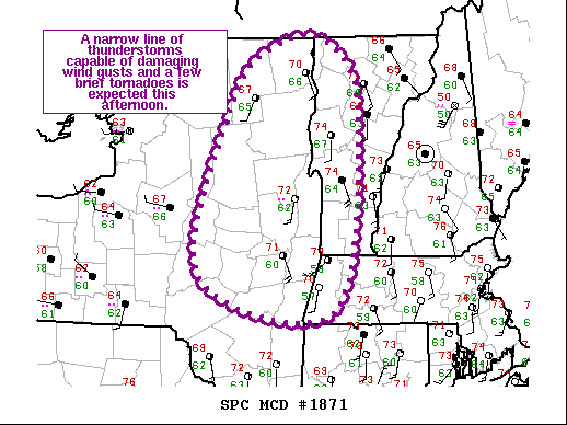
   Mesoscale Discussion 1871
   NWS Storm Prediction Center Norman OK
   1109 AM CDT Sat Oct 16 2021

   Areas affected...Northeast NY...Western VT...Far Western MA

   Concerning...Severe potential...Watch likely

   Valid 161609Z - 161815Z

   Probability of Watch Issuance...80 percent

   SUMMARY...A narrow line of storms is expected to develop and move
   east-northeastward this afternoon across northeast NY into western
   VT and far western MA. Damaging wind gusts and a couple of brief
   tornadoes are possible.

   DISCUSSION...Showers and thunderstorms moving across northern NY
   have shown a gradual strengthening trend over the past hour or so.
   At the same time the downstream air mass across northeast NY and
   adjacent western VT/far western MA continues to warm and
   destabilize. Low-level southerly flow has also been strengthening
   during this time (sampled well by the CXX VAD). Poor lapse rates
   should keep buoyancy modest, but the strong forcing for ascent and
   favorable vertical shear will still likely result in a narrow
   convective line capable of damaging wind gusts and perhaps even a
   tornado or two. The tornado threat appears to be relatively greater
   across in the NY/VT border vicinity where temperatures have climbed
   into the low/mid 70s amid mid 60s dewpoints. One or more watches
   (including the potential for a tornado watch along the NY/VT border)
   will likely be needed soon to address this developing severe threat.

   ..Mosier/Grams.. 10/16/2021

   ...Please see www.spc.noaa.gov for graphic product...

   ATTN...WFO...BOX...BTV...ALY...BGM...

   LAT...LON   44247456 44857404 44987321 44277272 42177307 42517496
               44247456
|
|
Top/All Mesoscale Discussions/Forecast Products/Home
|
|


 @NWSSPC