|
| Mesoscale Discussion 1830 |
|
< Previous MD Next MD >
|
|
Mesoscale Discussion 1830
NWS Storm Prediction Center Norman OK
0500 AM CDT Mon Oct 11 2021
Areas affected...Portions of southwestern MO
Concerning...Severe potential...Watch unlikely
Valid 111000Z - 111200Z
Probability of Watch Issuance...20 percent
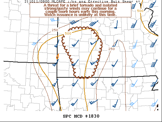
SUMMARY...A threat for a brief tornado and isolated strong/gusty
winds may continue for a couple more hours early this morning. Watch
issuance is unlikely at this time.
DISCUSSION...A low-topped line of convection has recently moved into
parts of southwestern MO. A strong, 50+ kt low-level jet is present
over this region. This low-level jet and a pronounced southwesterly
mid-level jet associated with a shortwave trough ejecting from the
southern Plains across the Ozarks are supporting strong low-level
and deep-layer shear. One of the cells embedded within the
low-topped line recently acquired low-level rotation, and a
corresponding CC minimum in dual pol radar data from KSGF. Although
the low-level shear remains rather favorable for continued storm
organization in the short term across southwestern MO, the
thermodynamic environment is much more marginal. A leading wave of
convection has already moved across this region, with surface
temperatures generally in the upper 60s. Weak boundary-layer
instability should continue to limit updraft intensities,
particularly as these storms move eastward and away from a narrow,
maximized corridor of this instability characterized by MLCAPE
around 500 J/kg. While a brief tornado and strong/gusty winds may
continue to be a threat for the next couple of hours, the overall
severe threat will probably remain too isolated to justify new watch
issuance early this morning.
..Gleason/Edwards.. 10/11/2021
...Please see www.spc.noaa.gov for graphic product...
ATTN...WFO...SGF...EAX...
LAT...LON 37629426 37919437 38269393 38269310 37769260 37089279
36539306 36539377 36829380 37309403 37629426
|
|
Top/All Mesoscale Discussions/Forecast Products/Home
|
|


 @NWSSPC