|
| Mesoscale Discussion 741 |
|
< Previous MD Next MD >
|
|
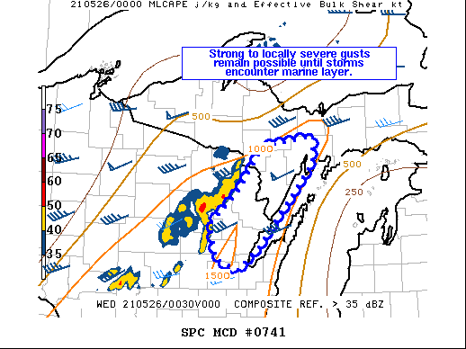
   Mesoscale Discussion 0741
   NWS Storm Prediction Center Norman OK
   0756 PM CDT Tue May 25 2021

   Areas affected...Upper Fox River Valley vicinity into southern Upper
   Peninsula of Michigan

   Concerning...Severe Thunderstorm Watch 203...

   Valid 260056Z - 260230Z

   The severe weather threat for Severe Thunderstorm Watch 203
   continues.

   SUMMARY...Strong to locally severe gusts possible in the near-term,
   particularly for southern portions of the Upper Peninsula.

   DISCUSSION...The 00Z GRB sounding showed mid-level lapse rates of
   around 7 C/km with 42 kts of effective shear. The portion of the
   line moving into the Upper Peninsula is moving at around 40-45 kts.
   This would suggest that even marginal enhancement of the winds by
   the convection would result in strong to perhaps locally severe
   gusts. Within the past 20-30 minutes, KIMT ASOS measured 44 kts.
   These gusts will remain possible until the line encounters greater
   MLCIN with the marine layer.

   ..Wendt.. 05/26/2021

   ...Please see www.spc.noaa.gov for graphic product...

   ATTN...WFO...MQT...GRB...

   LAT...LON   45478818 46028775 46148683 45808687 44988765 44738788
               44478820 44638859 45058868 45478818
|
|
Top/All Mesoscale Discussions/Forecast Products/Home
|
|


 @NWSSPC