|
| Mesoscale Discussion 668 |
|
< Previous MD Next MD >
|
|
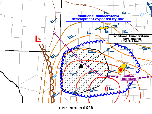
   Mesoscale Discussion 0668
   NWS Storm Prediction Center Norman OK
   0129 AM CDT Tue May 18 2021

   Areas affected...portions of southwest TX

   Concerning...Severe Thunderstorm Watch 187...

   Valid 180629Z - 180800Z

   The severe weather threat for Severe Thunderstorm Watch 187
   continues.

   SUMMARY...Additional thunderstorms are expected to develop over
   western portions of WW 187 over the next hour or two. Large hail
   will be the main threat, but locally damaging gusts also could
   occur.

   DISCUSSION...A deepening line of cumulus has been noted in the
   GOES-16 nighttime microphysics product over the past 30 minutes or
   so from just northwest of Ft. Stockton to just south of Midland.
   Most recently, weak midlevel reflectivity cores have become evident
   in regional radar as well. This activity is developing to the east
   of a dryline in moist upslope low level flow and to the south of an
   outflow boundary. Strong instability, with MLCAPE values from
   1500-3500 J/kg are in place, and very steep midlevel lapse rates
   greater than 8 C/km remain over the region amid effective shear
   greater than 40 kt and a 30+ kt southerly low level jet. This should
   support organized, somewhat elevated supercells. Large hail and
   locally strong gusts could accompany these cells.

   ..Leitman.. 05/18/2021

   ...Please see www.spc.noaa.gov for graphic product...

   ATTN...WFO...SJT...MAF...

   LAT...LON   32059994 31359942 30470014 30310186 30530291 31270297
               31940284 32320190 32400120 32350075 32100006 32059994
|
|
Top/All Mesoscale Discussions/Forecast Products/Home
|
|


 @NWSSPC