|
| Mesoscale Discussion 639 |
|
< Previous MD Next MD >
|
|
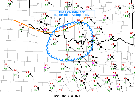
   Mesoscale Discussion 0639
   NWS Storm Prediction Center Norman OK
   0346 PM CDT Sun May 16 2021

   Areas affected...South-Central OK/Northwest TX

   Concerning...Severe potential...Watch unlikely

   Valid 162046Z - 162215Z

   Probability of Watch Issuance...20 percent

   SUMMARY...A relatively small spatial and temporal corridor for
   supercell intensification/organization exists across south-central
   OK and northwest TX.

   DISCUSSION...Recent visible satellite imagery shows that the area
   just downstream from the outflow associated with the MCV and
   persistent convection over central OK has cleared out. Temperatures
   in this region have quickly increased into the upper 70s/low 80s
   amid dewpoints in the mid to upper 60s. Additionally, the surface
   winds within this region have backed, with numerous sites now
   reporting southeasterly winds around 10 kt. Overall convective
   evolution within this corridor is uncertain, particularly given the
   westward/northwestward moving outflow coming from north-central TX.
   However, potential exists for the development of a strong to severe
   storm, particularly if the storm over Cotton County OK is able to
   maintain intensity. As a result, a very conditional risk for hail,
   damaging wind gusts, and perhaps even a brief tornado exists.

   ..Mosier/Guyer.. 05/16/2021

   ...Please see www.spc.noaa.gov for graphic product...

   ATTN...WFO...FWD...OUN...

   LAT...LON   33819889 34339853 34659763 34649723 34629704 34389673
               33879664 33739668 33479676 33239711 33129754 33079813
               33219866 33399892 33819889
|
|
Top/All Mesoscale Discussions/Forecast Products/Home
|
|


 @NWSSPC