|
| Mesoscale Discussion 1573 |
|
< Previous MD Next MD >
|
|
Mesoscale Discussion 1573
NWS Storm Prediction Center Norman OK
0603 PM CDT Mon Jul 22 2019
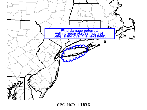
Areas affected...much of Long Island NY
Concerning...Severe Thunderstorm Watch 538...
Valid 222303Z - 230000Z
The severe weather threat for Severe Thunderstorm Watch 538
continues.
SUMMARY...Strong, damaging winds will be possible across much of
Long Island over the next hour.
DISCUSSION...A bowing segment that moved across, and produced
widespread measured severe/wind damage, the Philadelphia metro
vicinity is now moving toward Long Island at around 50 kts and will
impact much of the Long Island vicinity over the next hour. Radar
trends continue to indicate strong velocity signatures of around
60-70 kt around 3 kft. Additionally, the VWP data from KDIX 88-D
showed 55 kt westerly winds just a few hundred feet ARL. As such,
severe wind gusts capable of producing damage will be possible
across much of Long Island over the next hour.
..Leitman.. 07/22/2019
...Please see www.spc.noaa.gov for graphic product...
ATTN...WFO...OKX...
LAT...LON 40487377 40647382 40827370 40977315 40977313 41017288
40987265 40887256 40787262 40607302 40507333 40467344
40437364 40487377
|
|
Top/All Mesoscale Discussions/Forecast Products/Home
|
|


 @NWSSPC