|
| Mesoscale Discussion 1572 |
|
< Previous MD Next MD >
|
|
Mesoscale Discussion 1572
NWS Storm Prediction Center Norman OK
0522 PM CDT Mon Jul 22 2019
Areas affected...Southeast Arizona and far southwest New Mexico
Concerning...Severe potential...Watch possible
Valid 222222Z - 230015Z
Probability of Watch Issuance...40 percent
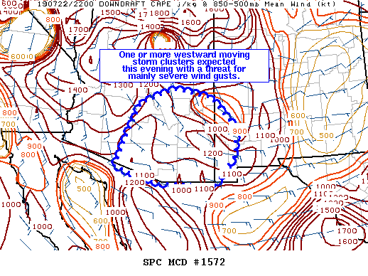
SUMMARY...Storms forming over the higher terrain in southern Arizona
and eastern Arizona/western New Mexico are expected to congeal and
move westward through the evening with a threat for severe wind
gusts.
DISCUSSION...Storms are in their initial development stages in the
higher terrain south of Tuscon and also along the mountains
northeast of Phoenix southeastward into western New Mexico. These
storms should be efficient downdraft producers considering the hot
surface temperatures, very steep low-level lapse rates, and high
cloud bases. As outflow boundaries collide, these storms are
expected to congeal into one or more clusters that move westward
through the evening. These clusters will likely maintain some
organization given around 25-30 knots of effective shear, and may
pose a threat for severe wind gusts and possibly blowing dust. The
threat will likely be maximized near Tuscon in the next few hours
with the potential for storms to impact the Phoenix area by late
this evening.
A severe thunderstorm watch may be needed to cover the threat
through the evening.
..Bentley/Edwards.. 07/22/2019
...Please see www.spc.noaa.gov for graphic product...
ATTN...WFO...ABQ...EPZ...TWC...FGZ...PSR...
LAT...LON 31250901 31291112 31771278 32671243 33791189 34281057
34020917 33030820 32140833 31250901
|
|
Top/All Mesoscale Discussions/Forecast Products/Home
|
|


 @NWSSPC