|
| Mesoscale Discussion 1294 |
|
< Previous MD Next MD >
|
|
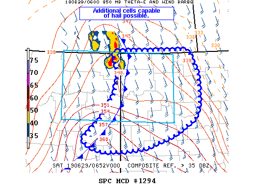
   Mesoscale Discussion 1294
   NWS Storm Prediction Center Norman OK
   0215 AM CDT Sat Jun 29 2019

   Areas affected...northeast Montana into northwest North Dakota

   Concerning...Severe Thunderstorm Watch 459...

   Valid 290715Z - 290915Z

   The severe weather threat for Severe Thunderstorm Watch 459
   continues.

   SUMMARY...While the primary wind threat has ended, additional cells
   capable of hail may develop tonight.

   DISCUSSION...A potent bow echo has weakened as it moved into
   northwest ND and across the international border. An outflow
   boundary extends southwest from the original bow, with recent
   indications of new storms attempting to develop along it. Lift along
   the wind shift as well as continued warm/moist air advection above
   the cooling boundary layer may support a few severe storms capable
   of hail. These storms may remain elevated, thus a wind threat is not
   expected. If storm coverage becomes more than anticipated,
   additional areas may need to be added to the watch, in western or
   northern ND. Otherwise, the severe threat will continue to end from
   west to east behind the main outflow boundary.

   ..Jewell.. 06/29/2019

   ...Please see www.spc.noaa.gov for graphic product...

   ATTN...WFO...BIS...GGW...

   LAT...LON   47000531 47520465 48080423 48550409 48850425 49040426
               49050167 48490135 47850133 47490145 47100218 46810319
               46750393 46730460 46840512 47000531
|
|
Top/All Mesoscale Discussions/Forecast Products/Home
|
|


 @NWSSPC