|
| Mesoscale Discussion 1659 |
|
< Previous MD Next MD >
|
|
MESOSCALE DISCUSSION 1659
NWS STORM PREDICTION CENTER NORMAN OK
0906 PM CDT MON JUL 18 2011
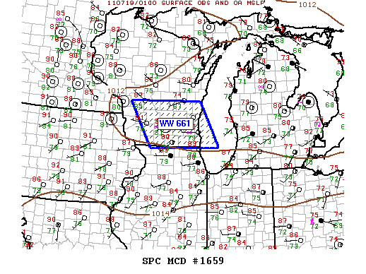
AREAS AFFECTED...SRN WI...LOWER LAKE MI
CONCERNING...SEVERE THUNDERSTORM WATCH 661...
VALID 190206Z - 190300Z
THE SEVERE WEATHER THREAT FOR SEVERE THUNDERSTORM WATCH 661
CONTINUES.
CONVECTION HAS GRADUALLY DECREASED ACROSS MUCH OF WW661...POSSIBLY
DUE TO COOLER BOUNDARY LAYER AND LACK OF APPRECIABLE FORCING.
HOWEVER...A NEW STRONG UPDRAFT HAS EMERGED OVER JEFFERSON COUNTY IN
SRN WI JUST AHEAD OF CONVECTIVE OUTFLOW AND LAKE BREEZE. THERE IS
SOME RISK THAT A FEW STRONG/ISOLATED SEVERE STORMS MAY DRIFT INTO
EXTREME NRN IL ALONG THE LAKE SHORE. IF THIS OCCURS GUSTY WINDS
WOULD BE THE PRIMARY THREAT. WILL CONTINUE TO MONITOR CONVECTIVE
TRENDS.
..DARROW.. 07/19/2011
ATTN...WFO...GRB...LOT...MKX...DVN...ARX...
LAT...LON 43919083 43918781 42458702 42438994 43919083
|
|
Top/All Mesoscale Discussions/Forecast Products/Home
|
|


 @NWSSPC