|
| Mesoscale Discussion 1623 |
|
< Previous MD Next MD >
|
|
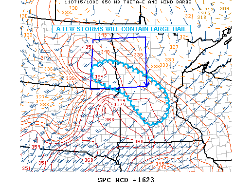
   MESOSCALE DISCUSSION 1623
   NWS STORM PREDICTION CENTER NORMAN OK
   0630 AM CDT FRI JUL 15 2011

   AREAS AFFECTED...ERN ND...NWRN MN

   CONCERNING...SEVERE THUNDERSTORM WATCH 646...

   VALID 151130Z - 151330Z

   THE SEVERE WEATHER THREAT FOR SEVERE THUNDERSTORM WATCH 646
   CONTINUES.

   SEVERAL VERY STRONG STORMS WITH LARGE HAIL ARE ONGOING MAINLY OVER W
   CNTRL MN...IN A ZONE OF WARM ADVECTION AND NEAR THE INSTABILITY
   GRADIENT. DEEP LAYER SHEAR REMAINS QUITE FAVORABLE FOR ELEVATED
   SUPERCELLS...AND IN GENERAL STORMS HAVE BEEN ABLE TO PERSIST AS THEY
   HAVE TRAVELED SEWD. WHILE MUCH OF THE NRN PORTION OF WW 646 MAY BE
   FINISHED...A SEVERE THREAT WILL REMAIN OVER SRN PORTIONS...AND ALSO
   INTO CNTRL MN WHERE A NEW WATCH MAY BE NEEDED.

   ..JEWELL.. 07/15/2011


   ATTN...WFO...DLH...MPX...FGF...ABR...BIS...

   LAT...LON   44429469 45339563 45789606 46149740 46369817 46869838
               47229742 47039620 46549485 46259429 45779356 45289342
               44839344 44409408 44429469
|
|
Top/All Mesoscale Discussions/Forecast Products/Home
|
|


 @NWSSPC