|
| Mesoscale Discussion 1000 |
|
< Previous MD Next MD >
|
|
MESOSCALE DISCUSSION 1000
NWS STORM PREDICTION CENTER NORMAN OK
0524 PM CDT FRI MAY 27 2011
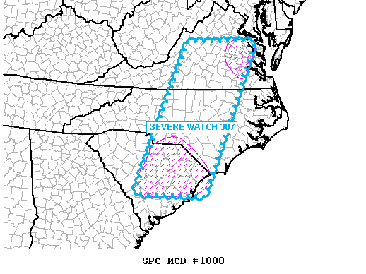
AREAS AFFECTED...SC/NC/VA
CONCERNING...SEVERE THUNDERSTORM WATCH 387...
VALID 272224Z - 272330Z
THE SEVERE WEATHER THREAT FOR SEVERE THUNDERSTORM WATCH 387
CONTINUES.
MUCH OF THE AIR MASS ACROSS WATCH 387 HAS BEEN OVERTURNED AND
STABILIZED. HOWEVER...POCKETS OF UNSTABLE AIR REMAIN...NAMELY OVER
SC AND ALSO ERN VA. HERE...ONGOING STORMS MAY STILL BE CAPABLE OF
SEVERE HAIL. GIVEN DECREASING AREAL COVERAGE OF SEVERE...THE WATCH
WILL BE ALLOWED TO EXPIRE AT 23Z AND ADDITIONAL WATCHES ARE
UNLIKELY.
..JEWELL.. 05/27/2011
ATTN...WFO...AKQ...MHX...LWX...RAH...ILM...RNK...CHS...CAE...
GSP...
LAT...LON 33177881 33228140 38117944 38107667 33177881
|
|
Top/All Mesoscale Discussions/Forecast Products/Home
|
|


 @NWSSPC