| Tornado Reports (CSV) (Raw Tornado CSV)(?) |
|---|
Time | | Location | County | State | Lat | Lon | Comments |
| 2300 | | 4 WSW Iowa City Municip | Johnson | IA | 4162 | 9162 | Tornado on the ground at IA 1 and Phebe Ln ... heading towards Iowa City ... LE Cruiser hit with debris and heavy rain ... lost visual contact. (DVN) |
| 2307 | | 3 W Nichols | Muscatine | IA | 4148 | 9136 | Tornado on the ground 2.5 W of Nichols ... IA. (DVN) |
| Hail Reports (CSV) (Raw Hail CSV)(?) |
|---|
Time | Size | Location | County | State | Lat | Lon | Comments |
| 1629 | 100 | 5 ENE Pleasant Dale | Lancaster | NE | 4082 | 9684 | Hail slightly larger than a quarter ... lasted 2-4 minutes. (OAX) |
| 1635 | 100 | 5 W Lincoln | Lancaster | NE | 4083 | 9678 | Report from mPING. (OAX) |
| 1635 | 100 | 6 SE Malcolm | Lancaster | NE | 4086 | 9678 | Report from mPING. (OAX) |
| 1636 | 125 | 6 WNW Lincoln | Lancaster | NE | 4085 | 9679 | (OAX) |
| 1640 | 100 | 5 NNW Lincoln | Lancaster | NE | 4088 | 9674 | (OAX) |
| Wind Reports (CSV) (Raw Wind CSV)(?) |
|---|
Time | Speed | Location | County | State | Lat | Lon | Comments |
| 2106 | 64 | 21 ENE Willcox | Cochise | AZ | 3232 | 10948 | (TWC) |
| 2139 | 60 | 5 NW Harper | Harper | KS | 3734 | 9809 | (ICT) |
| 2145 | 65 | 5 NW Harper | Harper | KS | 3734 | 9809 | (ICT) |
| 2210 | 70 | 1 W Millersburg | Iowa | IA | 4157 | 9218 | estimated 70 mph gusts and getting stronger. relayed by emergency management. time estimated by radar. (DVN) |
| 2220 | UNK | Carmen | Alfalfa | OK | 3658 | 9846 | Multiple power poles with varying degrees of wind damage ... including a few snapped. Radar estimated time. (OUN) |
| 2220 | 67 | 6 NNE Viola | Sedgwick | KS | 3757 | 9760 | (ICT) |
| 2222 | 60 | 1 W Andale | Sedgwick | KS | 3779 | 9765 | (ICT) |
| 2232 | 59 | 1 SE Wichita Eisenhower | Sedgwick | KS | 3765 | 9743 | (ICT) |
| 2232 | 65 | 3 NW Wichita Eisenhower | Sedgwick | KS | 3769 | 9747 | (ICT) |
| 2243 | UNK | 1 W Kalona | Washington | IA | 4149 | 9172 | Trailer blown over on Highway 22 near Kalona. Time estimated by radar. (DVN) |
| 2245 | 60 | 1 SE Wichita Eisenhower | Sedgwick | KS | 3765 | 9743 | (ICT) |
| 2246 | 68 | 1 NW Derby | Sedgwick | KS | 3756 | 9727 | (ICT) |
| 2246 | UNK | 3 WNW Downtown Wichita | Sedgwick | KS | 3771 | 9739 | Large tree down on home near 13th and West. Report came in via social media. (ICT) |
| 2247 | 63 | Newton Airport | Harvey | KS | 3806 | 9728 | (ICT) |
| 2249 | 67 | 2 NE East Wichita | Sedgwick | KS | 3771 | 9723 | Reported by KAKE Broadcast media. (ICT) |
| 2249 | 60 | 1 WNW Amish | Johnson | IA | 4154 | 9180 | (DVN) |
| 2250 | UNK | 4 SSE Maize | Sedgwick | KS | 3772 | 9744 | Tree blocking road near 21st and Tyler. (ICT) |
| 2250 | UNK | 3 SE Maize | Sedgwick | KS | 3774 | 9743 | Trees down. Report came in via social media. (ICT) |
| 2251 | 81 | 2 SSW Williamstown | Johnson | IA | 4154 | 9174 | Measured on Davis weather station. (DVN) |
| 2253 | UNK | 1 SSW Andover | Butler | KS | 3768 | 9714 | *** 3 INJ *** Report of a fireworks tent blown over with 3 injuries. Report was received via local TV. (ICT) |
| 2254 | 70 | Andover | Butler | KS | 3769 | 9714 | (ICT) |
| 2255 | UNK | 1 NNW Downtown Wichita | Sedgwick | KS | 3770 | 9735 | Reported several large tree limbs down in Riverside Park. (ICT) |
| 2255 | 62 | 2 W Whitewater | Harvey | KS | 3797 | 9719 | (ICT) |
| 2258 | 63 | 3 ESE Bel Aire | Sedgwick | KS | 3775 | 9722 | AWOS station KAAO 2 ESE Bel Aire. (ICT) |
| 2258 | 65 | 1 NNW Newton | Harvey | KS | 3805 | 9735 | (ICT) |
| 2259 | 59 | 2 WSW Towanda | Butler | KS | 3778 | 9703 | (ICT) |
| 2301 | 58 | 1 ENE Whitewater | Butler | KS | 3797 | 9713 | (ICT) |
| 2305 | 81 | Riverside | Washington | IA | 4148 | 9157 | relayed by a spotter. time estimated. (DVN) |
| 2312 | UNK | Augusta | Butler | KS | 3769 | 9697 | Reports of power lines down. (ICT) |
| 2312 | UNK | 5 E Elbing | Butler | KS | 3805 | 9703 | 2 inch diameter tree limbs down. (ICT) |
| 2317 | 60 | 4 NNW Coffey | Harrison | MO | 4015 | 9403 | Social Media report 60 mph wind gust along I-35. (EAX) |
| 2319 | 70 | Burns | Marion | KS | 3809 | 9689 | (ICT) |
| 2320 | 60 | 5 ENE Peabody | Marion | KS | 3820 | 9702 | (ICT) |
| 2325 | 60 | Ainsworth | Washington | IA | 4129 | 9155 | (DVN) |
| 2330 | UNK | Cameron | Clinton | MO | 3974 | 9424 | Reported small tree branches down with storm. (EAX) |
| 2335 | 60 | Cameron | Clinton | MO | 3974 | 9424 | AWOS reported gust of 60 mph. (EAX) |
| 2344 | 63 | 3 SE Matfield Green | Chase | KS | 3813 | 9653 | (ICT) |
| 2350 | UNK | Plattsburg | Clinton | MO | 3956 | 9446 | Reported tree blown over. (EAX) |
| 2350 | 60 | 2 SSE Cameron | Clinton | MO | 3972 | 9422 | Anemometer reported 60 mph wind gusts. (EAX) |
| 2350 | 60 | Brimson | Grundy | MO | 4014 | 9374 | Public/Facebook reported estimated wind gusts up to 60 mph. (EAX) |


 @NWSSPC
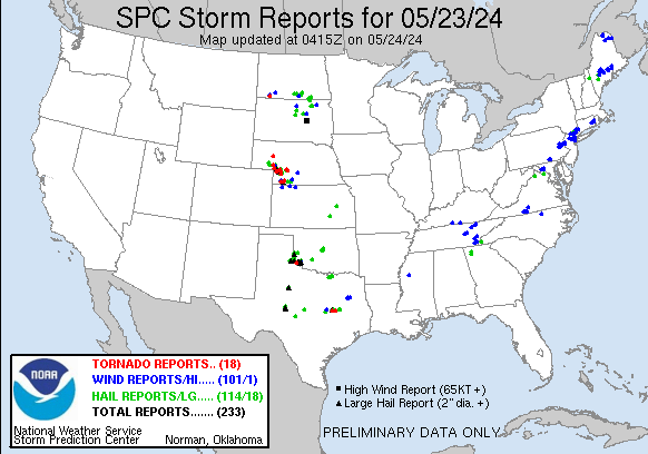