1. SPC questions (top)
1.1 What is the Storm Prediction Center?
The Storm Prediction Center (SPC) is a part of the National Weather Service (NWS) and is
one of nine National Centers for Environmental Prediction. Our mission is to provide timely and accurate
forecasts and watches for severe thunderstorms and tornadoes over the
contiguous United States. The SPC also issues forecasts for hazardous winter and fire weather.
1.2 When was the SPC formed?
SPC can trace its origin to the birth of the Weather Bureau Severe Weather Unit (SWU) in 1952. This unit was renamed
the Severe Local Storm Warning Center (SELS) in 1953. SELS became the National Severe Storms Forecast
Center (NSSFC) in 1966. NSSFC was renamed to the Storm Prediction Center (SPC) in 1995.
For more information on SELS and SPC history, please see this brief overview page
and/or download this PowerPoint poster (29 MB).
1.3 Where is the SPC located?
We are located in Norman, Oklahoma.
1.4 Is the SPC a part of the National Severe Storms Laboratory?
The SPC is not a part of the National Severe Storms Laboratory
(NSSL).
We are co-located in Norman with them and other NWS organizations such as
the Norman Weather Forecast Office (WFO),
the Radar Operations Center,
and the Warning Decision Training Branch.
1.5 How can the media or the public, tour or visit the SPC?
PUBLIC, GROUP, and SCHOOL TOURS
Tours of the National Weather Center (NWC) in Norman, located on
the south University of Oklahoma (OU) campus, are offered weekdays with each tour lasting 60-90 minutes.
The tour provides a comprehensive overview of the NWC and the units
housed within including the Storm Prediction Center,
the Norman WFO, and NSSL, as well as the OU School of Meteorology, the NWC observation deck, classroom, and
laboratory facilities.
You must make reservations for tours as space is limited.
For further information or to request an NWC tour, please see the NWC
Tour Information page.
MEDIA REQUESTS
Interviews with SPC staff, TV shoots, and photo shoots by members of the
media should be arranged first through Keli Pirtle, NOAA Communications,
(405) 325-6933, or email
Keli.Pirtle@noaa.gov.
If Keli is unavailable, the backup contacts for urgent
media inquiries are Patrick Marsh (SPC Warning Coordination Meteorologist)
at spc.wcm@noaa.gov,
(405) 325-2080.
1.6 What is the SPC copyright information and web links exchange policy?
We are pleased that you find our web site useful and you are certainly
welcome to link to any of our pages.
Information on government servers is public domain, unless specifically annotated otherwise, and may be used freely by the public.
NWS data and products form a national information database and
infrastructure which can be used by other government agencies,
the private sector, the public and the global community.
We encourage innovative and constructive uses of NWS data and products,
particularly when they contribute to the protection of life and
property and the enhancement of the national economy.
While you are free to use NWS data and products, a few words of
caution are in order.
First, NOAA and NWS logos and names cannot be used in a manner that
implies an endorsement or affiliation with NOAA/NWS.
As NWS information changes rapidly in response to weather and climate
events, special attention should be given to the date and
time of the data and products being displayed.
In addition, NWS information may not be modified in content and then
presented as official government material.
NWS is providing this data as is and the user assumes any risk related
to using this data.
And in no event is NWS liable to you or anyone else due to your use
of this data.
Finally, as required by 17 U.S.C. 403, third parties producing
copyrighted works consisting predominantly of the material appearing
in NWS web pages must provide notice with such work(s) identifying
the NWS material incorporated and stating that such material is
not subject to copyright protection.
We do not provide reciprocal links. Our linking policy requires that any links outside of the
U.S. government meet specific standards and requirements. The data must not be available from Federal agencies, must be
necessary for and material to the presentation of agency information,
and that the contents of the linked pages meet Section 515 Information
Quality standards and comply with Department of Commerce restrictions
on lobbying.
1.7 How does SPC forecast severe weather?
That's a simple question with a complex and ever-changing answer. The ways we make a severe weather forecast vary from event to event,
as much as the weather itself, and depends on the timing, location, and intensity of the hail, thunderstorm wind, and tornado threats.
This PowerPoint poster (9 MB) gives a summary of some of the tools and concepts we use in making severe weather forecasts.
1.8 Are there any opportunities for internship at the SPC?
The Storm Prediction Center does not hire summer students/interns. However, if you are a NOAA Hollings Student (http://www.noaa.gov/office-education/hollings-scholarship) or are selected to participate in the National Weather Center REU program (https://www.caps.ou.edu/reu/), it may be possible to work with SPC staff on a summer research project.
2. Watch Questions (top)
2.1 What is a Severe Thunderstorm or Tornado Watch?
A Severe Thunderstorm Watch outlines an area where an organized episode of hail 1 inch diameter or
larger and/or damaging thunderstorm winds are expected during a two to eight hour period.
A Tornado Watch includes the large hail and damaging wind threats, as well as the
possibility of multiple tornadoes or a single intense tornado.
Typical watches cover about 25,000 square miles, or about half the size of Iowa.
Click to view a video clip on "What's a Watch"?
2.2 How many watches do you issue in a year?
The SPC issues approximately 1000 watches each year. Of course, the precise number varies from year to year, depending on weather.
2.3 Do you issue warnings?
The SPC only issues watches. Your local NWS office issues warnings for your area. Try the
NWS Organization page to help you find the nearest office to you.
2.4 What's the difference between a watch and a warning?
A watch means severe weather is possible during the next few hours, while a
warning means that severe weather has been observed, or is expected within the hour.
2.5 Does the SPC issue all severe weather watches and warnings?
The SPC issues all Severe Thunderstorm Watches and Tornado Watches. All
warnings are issued by local NWS offices (see Question 2.3)
2.6 Why are watches not issued for all severe storms?
Many severe thunderstorms affect only a small area for a short period of time,
making watches impractical. Watches are issued primarily for areas where well organized or
significant severe weather is possible, or the severe weather threat is
expected to persist for several hours.
2.7 I noticed the wording "THIS IS A PARTICULARLY DANGEROUS SITUATION" in some
of your watches. What does this mean? What is the criteria for a PDS watch?
The "Particularly Dangerous Situation" wording is used in Tornado Watches for rare situations
when long-lived intense tornadoes are likely. This enhanced wording may also accompany
Severe Thunderstorm Watches for widespread significant severe events, usually produced by exceptionally intense
derechos. PDS watches are issued, when in the opinion of the forecaster, the likelihood of significant events is boosted
by very volatile atmospheric conditions. Usually this decision is based on a number of atmospheric clues and parameters,
so the decision to issue a PDS watch is subjective with no hard criteria. However, the SPC goal is to have 3 out of every 4 PDS
Tornado Watches verifying with multiple intense tornadoes. PDS watches are most often issued with a High risk in Day 1 Convective Outlooks.
2.8 Do you forecast hurricanes and tropical storms?
We do not forecast hurricanes and tropical storms. That is done by the National Hurricane Center.
We do issue Tornado Watches for tropical cyclones striking the continental U.S. when conditions favor multiple tornadoes or a single intense tornado.
2.9 Where can I get a list of the points used for watch locations?
You can find a table containing these locations (sorted by lat/lon) here or (sorted by station ID) here.
2.10 What is the watch status line (line with an arrow inside a watch) and how is it interpreted?
When a watch is issued, the original threat is contained within the entire watch
area. When the SPC determines where the severe weather threat continues within
a Severe Thunderstorm or Tornado Watch, usually on an hourly basis, we issue a Watch Status Report.
Unless the whole watch area remains valid, the Watch Status Report includes points on a line that indicates where the severe weather threat remains from our
perspective. The severe weather threat is to the right of that line, as in our outlooks. As adjustments are made to the watch, you will see that yellow "status"
line shift across the original watch area. This gives local NWS offices, emergency managers, media, and the general public guidance as to where the threat remains for severe weather.
2.11 Who clears watches?
It is up to the local NWS forecast offices -- not SPC -- to clear or keep counties within the watch once SPC has issued it.
Our status lines (described above) are just for guidance purposes to describe the remaining threat area.
2.12 What do the watch probability numbers mean? How are these different from outlook probabilities?
Watch and outlook probabilities have different meanings and should not be compared to each other. Probability numbers for watches tell you the
chance that a certain kind of severe weather or combination of severe events (say, 2 or more tornadoes, or 6 or more combined severe hail/wind events) will happen
in the whole watch. This is much different from outlook probabilities, which describe the chance of severe weather within 25 miles of any point.
For more details on outlook probabilities, see Using the Convective Outlooks on the
SPC Products page.
Watch probabilities are tagged as Low, Moderate, or High. This is different than how the outlook risks are tied to their probability numbers.
For watches, the "Low" category contains probability values ranging from less than 2% to 20% (F2-F5 tornadoes), less than 5% to 20% (all other probabilities),
"Moderate" from 30% to 60%, and "High" from 70% to greater than 95%.
2.13 Do you have an email or text messaging service for watches and warnings?
SPC does not offer this type of service. However, there are several private weather companies and other federal agencies that do take NWS watches,
warnings, and other official weather bulletins and send them to individual e-mail addresses or cell numbers.
More information can be found at www.weather.gov/subscribe.
3. Outlook Questions (top)
3.1 What is this "Z" time that you use all over your outlooks and also in other SPC forecasts?
The time you see on our products is Universal Coordinated Time (UTC) (also known as Greenwich Mean Time (GMT) or Zulu in military
parlance -- hence the "Z" abbreviation).
We do this for simplicity since the SPC forecast domain covers multiple time zones across the entire 48 contiguous U.S. states, and since all official weather records for scientific use are stored by Z time. It doesn't change with time zone or with daylight versus standard time, so Z makes an efficient and standardized way to communicate a common time reference, no matter where you are.
Please visit this link for a conversion table.
Another good site to visit regarding the UTC/GMT/Z time and your local time is The Official U.S. Time.
3.2 Where can I find a list of the abbreviations and contractions that I see in
the Convective Outlooks?
We have a page devoted to the abbreviations and acronyms that you'll find in our products.
3.3 What do the Marginal, Slight, Enhanced, Moderate, and High risk categories in the Convective
Outlook mean?
Marginal, Slight, Enhanced, Moderate, and High risks represent progressively larger threats for organized severe storm episodes.
These risks, along with their numerical, abbreviated labels, and colors (1-MRGL-dark green, 2-SLGT-yellow, 3-ENH-orange, 4-MDT-red, 5-HIGH-magenta),
are based directly on the numerical probabilities of severe weather that we provide with every outlook.
See the Severe Weather Risks section on the SPC Products page for more information.
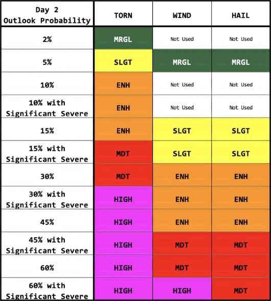
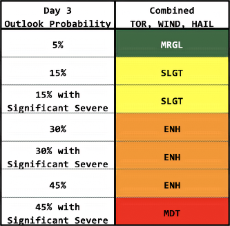
3.4 What do the Convective Outlook probabilities mean?
For Day 1, the percentage lines provide the chance that the given type of severe weather (tornado, hail, or damaging thunderstorm wind) will happen within
about 25 miles of a point. For Day 2 and Day 3, the probabilities cover all severe storm hazards together.
Categorical (1-MRGL, 2-SLGT, 3-ENH, 4-MDT, 5-HIGH) labels are tied directly to the probability numbers as defined in
this table for Day 1,
in this table for Day 2 and
this one for Day 3 Convective Outlooks.
3.5 Why do the probability values on the Convective Outlooks seem so low?
The probability values represent the chance of severe weather within about 25 miles of a point, which is about the size of a major metropolitan area.
Though severe storms tend to receive a large amount of media coverage, severe weather is uncommon at any one location.
Your chance of getting a tornado on any random day are very small, climatologically speaking. Put in that context, even a 10% chance of a tornado
within 25 miles of a point means a much bigger threat than usual, and should be taken seriously.
Think of how often tornadoes normally happen close to you on any given day, and those small-looking probabilities start to seem large by comparison!
3.6 What is that nameless light green area on the Day 1-3 Convective Outlooks?
The light green area on the categorical graphic is for general, (non-severe) thunderstorms, with a 10% or greater probability of thunderstorms to the right of the green line.
3.7 Where can I get a list of the points used for the Convective Outlook Areal Outline product?
You can find a table containing these locations -- sorted by longitude east-west here and sorted alphabetically by station IDs
here.
3.8 What do the points in the Convective and Fire Weather Outlook Areal Outline product mean?
The lat/lon numbers are expressed in decimal degrees to four decimals.
For example, in the following:
   CRIT   45300143 44580165 44280242 44530391 45390559 46360575
          49000652 49030478 49000161 48370159 46820149 45300143
the first latitude is 45.30 N and longitude is 101.43 W, the second latitude is
44.58 N and longitude is 101.65 W, and so on.
The latitude values are referenced as North and the longitude values are referenced as West.
For longitude values equal to or greater than 100, the leading 1 is dropped.
4. Weather Questions (top)
4.1 How does the NWS define severe weather?
There are many forms of hazardous, or severe weather. The primary mission
of the NWS is to provide forecasts and warnings for the protection of life and property. Forecasts can range from the climate
and seasonal outlooks issued by the CPC,
to the daily forecasts for the public issued by local NWS offices.
The NWS issues warnings
for heavy snow, freezing rain, high winds, flash flooding, river flooding, thunderstorms, tornadoes, tropical storms, and hurricanes.
In a broad sense, these are all defined as severe weather as any of them can and do pose a threat to life and property.
4.2 How does the NWS define a severe thunderstorm?
A severe thunderstorm refers to a thunderstorm producing hail that is at least 1 inch in diameter or larger, and/or wind gusts of 58 mph or
greater, and/or a tornado. Although lightning can be deadly, the NWS doesn't use it to define a severe thunderstorm.
If it did, every thunderstorm would be severe, by definition. Also, excessive rainfall may lead to deadly flash flooding, but heavy rain is not a
severe criterion either. The flood threat is handled through a separate set of watches and warnings from your local NWS office.
4.3 How does the SPC define a significant severe thunderstorm?
A significant severe thunderstorm refers to a thunderstorm producing hail that is at least 2 inches in diameter or larger,
and/or wind gusts of 75 mph or greater, and/or a tornado that produces EF2 or greater damage.
4.4 What is organized severe weather and why is it more important than non-organized severe weather?
To some degree, all thunderstorms are organized. We refer to organized severe storms as those which persist for several hours,
are capable of multiple and/or significant severe weather events, and which we are able to forecast consistently.
Organized severe storms tend to form in areas where the vertical wind shear is relatively
strong and has particular characteristics, while non-organized severe storms are most common when vertical wind shear is weak.
The most long-lived, intense tornadoes and largest hail are usually produced by supercell thunderstorms, while the most serious
convective wind storms are produced by bow echoes.
4.5 What environmental parameters are most often observed with organized severe weather?
In general, severe thunderstorms form in areas where moisture, instability, and lift are present. Additionally, long-lived severe thunderstorms are
often associated with strong vertical wind shear (e.g., winds that change direction and increase in speed with height). Unfortunately, thunderstorm
initiation is not well-understood, and weather observations are too widely spaced to detect all important small-scale features that influence storms.
4.6 Do you have any educational information about lightning?
NSSL has a great FAQ
about lightning.
NWS Pueblo also provides handy links
to web resources on lightning.
4.7 Where can information be obtained on the occurrence of lightning from a past storm event?
The SPC does not maintain a database for past lightning strikes. While the NWS does not endorse any commercial lightning vendors, there are numerous vendors of
lightning detection systems and data. A list of commercial vendors can be found at http://www.nws.noaa.gov/im/more.htm.
4.8 Can you give me details on a particular hailstorm, thunderstorm or
tornado which hit on a certain date? Or can you tell me about hail or wind damage for the last 20 years in a certain place?
Unfortunately, no. We don't have the resources or staffing to fulfill every local weather information request we receive. However, the National Climatic
Data Center (NCDC) does provide local weather event information and for severe weather events, in a publication called Storm Data or interactively
through the Storm Events Database.
4.9 What is a derecho and where do I learn more about them?
A derecho is a long-lived, widespread, severe, convective wind outbreak.
Derecho producing storm systems can also contain tornadoes, but they consist mostly of (and are defined by) damaging non-tornadic wind.
Sometimes, an intense derecho can result in hundreds of severe wind and damage reports spread along a swath covering multiple states, with deaths,
injuries, and many millions of dollars in losses. See the SPC derecho FAQ
for more information and some historical examples.
4.10 Can you tell me what the weather
will be like on a specific date? Or is it going to rain today?
SPC doesn't produce local weather forecasts, and doesn't have the staffing
to handle individual forecast requests like this. The SPC home page, along with the main page of any
other NWS center or office, will give you local forecasts by city, state, or ZIP code, using an entry box at the upper portion of the page.
5. Tornado Questions (top)
5.1 What is a tornado?
This is the first question
in the tornado FAQ.
Please read the information there.
5.2 How many tornadoes and tornado deaths occur in a year?
Please see the Climatology section of the Tornado FAQ.
5.3 How does SPC forecast tornadoes?
Please see the Forecasting section
in the tornado FAQ.
5.4 Do you have some tornado safety tips?
Many issues of tornado safety are also covered in the Tornado FAQ
under its Safety section.
5.5 How many tornadoes have there been in my state or county?
This question is answered in the Tornado FAQ.
6. Other Questions (top)
6.1 Why did some severe weather not
show up on your reports list? How do I get a list of reports for
a particular place or period of time?
The listings on the SPC Storm Reports page are
automatically collected from thunderstorm-related local storm reports (LSRs)
sent out by the local NWS offices. If there was no LSR for an event, or it arrived more than 10 days after
the event, the report won't show up here. Our storm reports list is preliminary and likely does not
contain all severe weather reports for any particular event. Storm surveys may be needed to confirm tornadoes, EF scale, find
out if damage really was from a tornado or other thunderstorm winds, etc.
You can search the NCDC Storm Events Database which provides the official,
final data for severe weather reports. This database takes a few months to compile, so if you need information
on more recent severe weather reports, please contact your local NWS office.
6.2 Where is your lightning data page? How do I get lightning data?
We don't have a web page with lightning data. Unlike most weather data in the U.S., which is collected by the NWS and paid for by tax dollars, lightning data is
privatized, meaning companies collect and distribute it for a price. You won't find it for free anywhere on the web unless the provider gives them a license
to do so. Lightning data (like you may see on TV weather reports) is sold on contract by companies which gather the strike or flash points through
sensors they have deployed around the country. NWS does get lightning data for internal forecast use, but because it is locked in proprietary contract,
it cannot be redistributed. Commercial lightning data providers can be found using "lightning data" in a reputable Internet search engine.
6.3 Where can I get information on building a safe
room in my house to help protect our family from tornadoes?
A structural engineer or contractor can help you plan a safe room or shelter
for your home. Helpful tips on getting started with safe rooms also are
provided by the
Federal Emergency Management Agency.
6.4 What is NOAA Weather Radio and how can it help to protect me?
NOAA Weather Radio is a broadcast system which is available 24 hours a day that
continuously plays the latest warnings, watches, and forecasts. These radio
broadcasts can save your life in severe weather situations. For further
information please refer to
NOAA Weather Radio page.
6.5 How does someone become a
meteorologist (at the SPC or elsewhere)?
Usually, a Bachelor of Science (B.S.) degree in Meteorology is required to
enter the field and work as a forecaster. Some course work and experience can
also be gained in the military, especially the Navy and Air Force. Many
forecasters continue on to graduate school and acquire advanced
degrees (M.S. and PhD) in meteorology, atmospheric science, mathematics,
and computer science.
6.6 How can I get a job at the SPC
or in meteorology?
See the NSSL Meteorologist Career Options page.
6.7 How can I become a professional storm chaser?
Very few people make a living as storm chasers. The vast majority of people
who chase storms do so as a hobby in their spare time, often at a cost of
hundreds or thousands of dollars a year. To become a professional storm
chaser, you must be able to consistently acquire and successfully
market your storm photographs and video. You may also develop enough skill
to have others pay to ride along with you on chases. However, it takes
many years to become a safe and successful storm chaser, and the market for
storm chase pictures/video and tours is quite competitive. The best way to
approach storm chasing is to ride along with more experienced chasers for
a few years, and practice severe storm forecasting at every opportunity.
6.8 How are the latitude and longitude
numbers expressed on the Storm Reports page?
The lat/lon numbers are expressed in decimal degrees to two decimals.
For example, in the following report:
1108 100 NEODESHA WILSON KS 3742 9568 (ICT)
the latitude is 37.42 (or 37.42N) and longitude is 95.68 (or -95.68W)
The latitude values are referenced as North, and the longitude values are
referenced as West and negative.
The negative signs are included in the comma separated values (CSV) files
for the ease of importing into other mapping programs.
6.9 What are the 3-letter IDs in the Storm Reports comment section?
The 3-letter IDs represent the reporting local NWS office for the report. For example,
QUARTER SIZED HAIL...STRONG WINDS WITH POWER OUTAGES AND VERY HEAVY RAIN. (OAX)
The report above was from (OAX) which is the NWS Omaha.
Click here for a listing of all local NWS offices by ID and Location.
6.10 What are the differences between the regular and the raw Storm Reports CSV files?
The differences between the regular versus raw CSVs are as follows:
- raw CSVs capture all decoded LSRs with deduplication of identical reports,
- the regular LSRs are deduplicated based on:
- same occurrence time
- same lat/lon location
In all categories, the most recently issued report of the pair is kept by comparing LSR issuance times.
We noticed sometimes the comments/remarks in the LSR regarding the same event can span multiple reports.
With the raw files, all comments are captured and anyone can decide how to deduplicate the LSRs themselves.
6.11 What are the differences between the filtered and the unfiltered Storm Reports?
Unfiltered:
On March 8, 2011, the SPC started providing unfiltered storm reports by removing space/time filtering on incoming NWS LSRs.
This approach is consistent with NWS storm-based verification methods.
However, identical reports are removed from SPC logs and should not appear on the preliminary maps and lists.
Filtered:
The space/time filtering had been used by SPC in an attempt to reduce duplicate reports and limit artificially inflated initial estimates of severe weather events when
many reports arrived for the same event. The filtering is applied to each of the tornado, hail, and wind reports separately.
The logic implemented for filtering is as follows:
- Same county and state
- Same regular expression of deaths/fatalities
- Spatial/temporal differences between pairs
- Less than 5 miles and 5 minutes for tornadoes
- Less than 10 miles and 15 minutes for hail and wind reports (the highest wind speed and largest hail size reports are kept).
The filtering logic is applied to tornado, hail, and wind reports separately. For example, a tornado report and hail report for
the same location and time are kept in their respective reports.
6.12 How do I unsubscribe from email/SMS weather alerts?
The NWS does not provide direct email/SMS weather alerts to the general public. The actual delivery of SPC products through email/SMS weather alerts are provided by private
vendors. See the NWS listing of sources for email/SMS weather alerts for further information.
6.13 What is the SPC/University of Oklahoma Career Experience Program?
The SPC and OU School of Meteorology (SoM) Career Experience Program is an unpaid, for credit opportunity offered through the SoM.
The objective is to provide the second semester junior or senior undergraduate, or first-year
graduate student holding strong interests in severe weather forecasting and related research
with a semester-long experience to focus their career goals and provide an opportunity to
apply meteorological principles in an operationally-oriented research setting.
The student will spend between 8-10 hours per week (3 credit hours of METR 3890) at the SPC
working on a research project related to U.S. hazardous weather events, culminating in a term
paper from the student. The student will have the opportunity to spend several days in the SPC
operations area to interact with forecasters and learn about the SPC severe weather forecast
process. An announcement is provided each semester with applications typically due in November (for spring) and April (for fall).
6.14 What is the difference between the experimental and the operational Storm Reports pages?
SPC has an over 15-year daily archive of preliminary LSRs via the operational Storm Reports page.
Historically, minimal change has occurred in the format and content, with certain parts of the LSR having been truncated or ignored for the case of brevity.
The experimental Storm Reports page contains more information by keeping the source of the report,
extending the remarks section to include all 500 characters, and saving whether the report magnitude was measured, estimated, or unknown.
Also, for the first time, the LSR automated decoder extends beyond severe weather to include winter weather related type reports
from local NWS offices. The winter weather LSRs include the following types:
Blizzard, Freezing Rain, Ice Storm, Heavy Snow, Sleet, and Snow. The experimental Storm Reports page
also provides search capabilities by States, and/or by County Warning Areas (CWAs), and by Time ranges.
6.15 What is the time coverage for each Storm Reports page?
The Storm Reports page is organized based on reports received from 1200 UTC to 1159 UTC the next day. For example, storm report page for 20150430 covers reports from 20150430 at 1200 UTC to 20150501 at 1159 UTC.
7. Fire Weather Questions (top)
7.1 What is a Critical Fire Weather Area?
Critical Fire Weather Areas for dry thunderstorms are typically issued when at least
scattered thunderstorms producing little wetting rain (<0.10 in) are expected to
occur where dried fuels exist. This can result in several wildfire ignitions,
particularly in the western U.S. during the summer.
Critical Fire Weather Areas for wind and relative humidity are typically issued when
strong winds (>20 mph) and low relative humidity are expected to occur where dried
fuels exist, resulting in a significant threat for rapidly-spreading wildfires.
7.2 What is an Extremely Critical Fire Weather Area?
Extremely critical areas are typically issued when very strong winds (>30 mph) and very low RH are expected
to occur with very dry fuels, resulting in extreme rates of wildfire spread.
Extremely Critical areas are rarely issued, similar to the low frequency of High Risk in the convective outlooks.
7.3 What criteria do you use in fire weather outlooks?
Guidelines that describe the various types of meteorological and fuel criteria that SPC uses is available in
the Fire Weather Outlooks section on the
SPC Products page.
7.4 Do you issue fire weather watches or red flag warnings?
The SPC only issues Fire Weather Outlooks. Local NWS offices issue Fire Weather Watches and Red Flag
Warnings for your area. Visit the NWS Fire Weather page for further information.
7.5 Where can I find historical information about wildfires?
The National Interagency Fire Center provides information for current and historical fires at this
page.
More unanswered questions?
Post your questions on the Feedback page.
|


 @NWSSPC