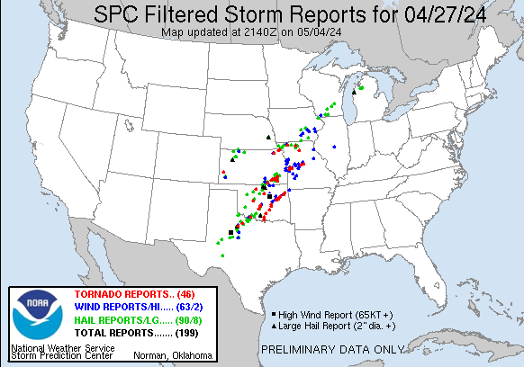
| Tornado Reports (CSV) (Raw Tornado CSV)(?) |
|---|
Time | | Location | County | State | Lat | Lon | Comments |
| 1821 | | Hillsdale | Garfield | OK | 3656 | 9800 | Buildings and trees damaged. (OUN) |
| 1855 | | 3 NNW Robinson | Brown | KS | 3985 | 9544 | Delayed report. (TOP) |
| 1909 | | 8 N Robinson | Brown | KS | 3993 | 9540 | Confirmed tornado. (TOP) |
| 1915 | | 2 WSW White Cloud | Doniphan | KS | 3997 | 9533 | (EAX) |
| 1947 | | 4 NW Goff | Nemaha | KS | 3970 | 9598 | Tornado reported by EM. (TOP) |
| 1950 | | 4 N Goff | Nemaha | KS | 3972 | 9593 | Tree damage to a line of trees with limbs torn off trees about 3 inch limbs reported from healthy trees. (TOP) |
| 2006 | | 3 W Knox City | Knox | TX | 3342 | 9987 | tornado at FM 222 and 1292. (OUN) |
| 2027 | | 6 SW Morrison | Payne | OK | 3623 | 9709 | 1 mile west of US-177 ... 1 mile south of Noble County line. (OUN) |
| 2031 | | 3 SSW Dexter | Cowley | KS | 3714 | 9674 | Small tornado reported south of Dexter. (ICT) |
| 2108 | | 6 W Seymour | Baylor | TX | 3361 | 9939 | Delayed Report Tornado first sighted about 6-8 miles west of Seymour along SH114/US82 at 408PM ... moved northeast and roped out near Lake Kemp at 440PM. (OUN) |
| 2112 | | 3 S Gentry | Gentry | MO | 4030 | 9443 | This EF1 tornado began near or just west of U.S. Highway 169 south of Gentry ... where a tractor trailer was blown over. Little damage was observed as the tornado moved (EAX) |
| 2113 | | 3 SE Gentry | Gentry | MO | 4031 | 9438 | Metal roof torn off residence. Metal in trees and some 4-6 inch limbs down. Time estimated via radar. (EAX) |
| 2119 | | Gentry | Gentry | MO | 4033 | 9442 | Missouri Highway Police reported tornado crossing HWY 169. (EAX) |
| 2130 | | 5 ESE Geary | Canadian | OK | 3560 | 9824 | Damage also reported about 4 miles NNW of Calumet. (OUN) |
| 2135 | | 10 N Kendall | Hamilton | KS | 3801 | 10155 | [Landspout] Landspout report from 10 N Kendall. Damaged outbuilding and power poles. Reported with picture and video. (DDC) |
| 2142 | | 1 S Moline | Elk | KS | 3735 | 9630 | Multiple brief tornadoes just south of Moline. Secondary rotation south of main tornado rotation area. (ICT) |
| 2142 | | 1 SW Howard | Elk | KS | 3746 | 9628 | Wedge tornado reported heading towards Howard. (ICT) |
| 2154 | | Elk Falls | Elk | KS | 3738 | 9619 | (ICT) |
| 2154 | | 1 NW Longton | Elk | KS | 3739 | 9610 | (ICT) |
| 2158 | | 1 SE Spickard | Grundy | MO | 4023 | 9358 | A weak EF0 tornado began southeast of Spickard east of 7th Avenue ... producing sporadic and intermittent tree damage along its path. The tornado tracked north-northeast (EAX) |
| 2235 | | 3 NE Fredonia | Wilson | KS | 3756 | 9579 | Very brief tornado. (ICT) |
| 2256 | | 5 ENE Benedict | Wilson | KS | 3764 | 9565 | DELAYED REPORT Brief tornado touchdown ... video included via facebook. (ICT) |
| 2340 | | 2 E Laclede | Linn | MO | 3978 | 9314 | Brief touchdown west of Brookfield. Time estimated from radar. (EAX) |
| 2354 | | 2 S Devol | Cotton | OK | 3416 | 9859 | Visual cone tornado reported buried in precip. (OUN) |
| 0045 | | 3 NE Independence | Montgomery | KS | 3726 | 9568 | Delayed report. Received two separate photos of a tornado northeast of Independence. Time and location estimated from radar. (ICT) |
| 0120 | | 3 NNE Cole | McClain | OK | 3515 | 9756 | Delayed Report ... Radar confirmed TDS ... one of two in close proximity. (OUN) |
| 0123 | | 3 SSE Butler | Bates | MO | 3822 | 9431 | This EF1 tornado began just east of Route YY and just south of State Highway 52 southeast of Butler in Bates County ... where minor tree damage was observed. The tornado (EAX) |
| 0130 | | 4 W Ballard | Bates | MO | 3836 | 9422 | This EF1 tornado began just south of Route 18 east of Passaic. Some of the worst damage of the tornado affected a farm property ... where one outbuilding collapsed ... an (EAX) |
| 0145 | | 5 NNW Montrose | Henry | MO | 3833 | 9402 | A brief EF0 tornado occurred north of Montrose from the same mesovortex that produced the tornado just southeast of Butler. The first signs of damage occurred just west (EAX) |
| 0148 | | 3 N Montrose | Henry | MO | 3830 | 9398 | Power flashes reported 3 Miles north of Montrose with visible funnel. (EAX) |
| 0153 | | 3 ENE Bradley | McClain | OK | 3490 | 9767 | Tornado debris signature on radar. (OUN) |
| 0220 | | 3 NNE Cole | McClain | OK | 3514 | 9756 | Tornado debris signature on radar. (OUN) |
| 0227 | | 3 NW Neodesha | Wilson | KS | 3745 | 9572 | (ICT) |
| 0228 | | 2 WNW Norman | Cleveland | OK | 3523 | 9748 | Notable damage at Homeland; strong radar signature matches at this time; additional damage around Norman. (OUN) |
| 0250 | | 6 ESE Buxton | Wilson | KS | 3742 | 9581 | Tornado reported on the ground. (ICT) |
| 0257 | | 2 WNW Ardmore | Carter | OK | 3419 | 9717 | Twitter Photo as tornado moved through Ardmore. (OUN) |
| 0324 | | Sulphur | Murray | OK | 3451 | 9697 | Noticeable TDS as tornado moved through town. Widespread damage reported across Sulphur. (OUN) |
| 0329 | | 5 SW Florence | Morgan | MO | 3854 | 9304 | Trees were uprooted along Ehlers and Butterfield Trail Road to the southwest of Florence during a tornado Saturday evening. The tornado had max winds of 75 mph with a w (SGF) |
| 0338 | | 6 SSE Francis | Pontotoc | OK | 3480 | 9655 | (OUN) |
| 0339 | | 1 W Holdenville | Hughes | OK | 3508 | 9642 | *** 1 FATAL *** Large TDS impacting near Spaulding ... western Holdenville and areas north of Holdenville. Widespread damage reported. (OUN) |
| 0359 | | 2 ENE Tipton | Moniteau | MO | 3867 | 9274 | An EF1 tornado formed shortly before 11pm on the 27th northeast of Tipton ... MO along Alexander Rd ... causing damage to both structures and trees before dissipating a m (LSX) |
| 0404 | | 5 SSE Bearden | Okfuskee | OK | 3529 | 9635 | TDS observed entering Okfuskee county; time estimated by radar. (TSA) |
| 0407 | | 2 ESE Bearden | Okfuskee | OK | 3534 | 9636 | house heavily damaged 2.5 miles east of hwy 48; time estimated by radar. (TSA) |
| 0410 | | Marietta | Love | OK | 3394 | 9712 | Extensive damage to buildings and trees reported in Marietta. (OUN) |
| 0512 | | Morris | Okmulgee | OK | 3561 | 9586 | (TSA) |
| 0521 | | 5 N Eram | Okmulgee | OK | 3569 | 9577 | This tornado developed east of Morris ... and moved northeast for about nine miles. Numerous trees were snapped or uprooted ... numerous power poles were snapped ... and s (TSA) |
| 0530 | | 2 SSW Jamesville | Muskogee | OK | 3573 | 9565 | This tornado developed north-northwest of Boynton ... moved northeast ... and dissipated near the Arkansas River. It uprooted trees and snapped large tree limbs. (TSA) |
| 0557 | | 2 WSW Wagoner | Wagoner | OK | 3594 | 9540 | This brief tornado uprooted or snapped several large trees ... and blew down power poles. (TSA) |
| 0559 | | 2 NE Porter | Wagoner | OK | 3589 | 9550 | TDS observed on radar; time estimated by radar. (TSA) |
| 0627 | | 3 NE Peggs | Cherokee | OK | 3612 | 9506 | TDS observed on radar; time estimated by radar. (TSA) |
| 0637 | | Leach | Delaware | OK | 3621 | 9492 | tornado brought down trees at hwy 412 alt and 540 road (near Leach) in Delaware county; time estimated by radar. (TSA) |
| Hail Reports (CSV) (Raw Hail CSV)(?) |
|---|
Time | Size | Location | County | State | Lat | Lon | Comments |
| 1608 | 125 | 2 S Ringwood | Major | OK | 3635 | 9825 | Report from mPING: Half Dollar (1.25 in.). (OUN) |
| 1619 | 175 | 3 SSW Seiling | Dewey | OK | 3611 | 9896 | (OUN) |
| 1619 | 175 | 3 SW Seiling | Dewey | OK | 3612 | 9896 | (OUN) |
| 1749 | 125 | 2 E Goodlett | Hardeman | TX | 3433 | 9986 | (OUN) |
| 1806 | 100 | 6 SW Eldorado | Jackson | OK | 3442 | 9973 | (OUN) |
| 1812 | 100 | 5 NW Winfield | Cowley | KS | 3729 | 9707 | (ICT) |
| 1835 | 125 | Corning | Holt | MO | 4025 | 9546 | Mping report. (EAX) |
| 1930 | 125 | Corning | Holt | MO | 4025 | 9546 | Corrects previous hail report from Corning. Mping report of half dollar size hail. (EAX) |
| 1932 | 225 | 2 W Tonkawa | Kay | OK | 3670 | 9735 | Report from mPING ... time is radar estimated. (OUN) |
| 1933 | 150 | 17 NE Benjamin | Knox | TX | 3376 | 9958 | Delayed Twitter Report. (OUN) |
| 1935 | 175 | 1 N Tonkawa | Kay | OK | 3669 | 9731 | Report from mPING. (OUN) |
| 1935 | 125 | 2 W Tonkawa | Kay | OK | 3670 | 9735 | Report from mPING. (OUN) |
| 1938 | 100 | 1 S Hobart | Kiowa | OK | 3502 | 9909 | Report from mPING ... time is radar estimated. (OUN) |
| 1939 | 100 | 1 NE Hobart | Kiowa | OK | 3504 | 9909 | Report from mPING. (OUN) |
| 1940 | 100 | 1 S Hobart | Kiowa | OK | 3502 | 9909 | Report from mPING. (OUN) |
| 1941 | 125 | Hobart | Kiowa | OK | 3503 | 9910 | Report from mPING ... time is radar estimated. (OUN) |
| 1942 | 250 | 1 SE Blackwell | Kay | OK | 3679 | 9727 | Multiple Twitter Photos. (OUN) |
| 1947 | 275 | 5 W Knox City | Knox | TX | 3342 | 9990 | (OUN) |
| 2000 | 175 | 1 WNW Maitland | Holt | MO | 4021 | 9509 | Golf ball-sized hail along HWY 113 at 3PM. (EAX) |
| 2002 | 275 | 3 ESE Ceresco | Saunders | NE | 4105 | 9659 | Delayed report from 4/26. (OAX) |
| 2003 | 100 | Arkansas City | Cowley | KS | 3707 | 9704 | (ICT) |
| 2010 | 100 | 4 N Bigelow | Holt | MO | 4017 | 9529 | Delayed social media report of quarter size hail on Interstate 29 near mile marker 88. Time estimated from radar and social media report. (EAX) |
| 2017 | 100 | 1 NW Braman | Kay | OK | 3694 | 9735 | Report from mPING ... time is radar estimated. (OUN) |
| 2017 | 125 | 2 S Maryville | Nodaway | MO | 4032 | 9487 | Social media report of half dollar size near Maryville. Time estimated from radar. (EAX) |
| 2038 | 100 | 2 N Dexter | Cowley | KS | 3721 | 9671 | (ICT) |
| 2054 | 100 | 1 SSW Ravenwood | Nodaway | MO | 4035 | 9468 | Media partner reported quarter-sized hail just south of Ravenwood ... MO along 136-HWY. (EAX) |
| 2057 | 100 | Sully | Jasper | IA | 4158 | 9284 | Quarter sized hail near Sully. (DMX) |
| 2100 | 150 | Sully | Jasper | IA | 4158 | 9285 | Delayed Report. Exact location not provided ... only town was given. (DMX) |
| 2110 | 175 | 7 N Oregon | Holt | MO | 4009 | 9511 | Report from mPING: Golf Ball (1.75 in.). (EAX) |
| 2113 | 100 | 1 E Red Springs | Baylor | TX | 3361 | 9939 | Report from mPING ... time is radar estimated. (OUN) |
| 2153 | 100 | 1 NNE Julien | Dubuque | IA | 4250 | 9078 | Report relayed by media. Time estimated using radar. (DVN) |
| 2154 | 150 | 8 S Omega | Kingfisher | OK | 3575 | 9818 | Report from mPING ... time is radar estimated. (OUN) |
| 2200 | 125 | 1 SW Bethany | Harrison | MO | 4026 | 9404 | Social media report of half dollar size hail in Bethany. Time estimated from radar. (EAX) |
| 2202 | 150 | 1 E Bethany | Harrison | MO | 4027 | 9400 | Report from mPING: Ping Pong Ball (1.50 in.). Time corrected from radar. (EAX) |
| 2209 | 100 | 5 E Bethany | Harrison | MO | 4026 | 9393 | Social media report of quarter size hail near Bethany. Time and location estimated from social media report and radar. (EAX) |
| 2222 | 100 | Victor | Iowa | IA | 4173 | 9229 | Dime ... Nickel ... and Quarter ground covered. (DVN) |
| 2223 | 150 | Electra | Wichita | TX | 3403 | 9892 | (OUN) |
| 2227 | 100 | 1 W New Albany | Wilson | KS | 3757 | 9596 | (ICT) |
| 2231 | 100 | 2 SW Toronto | Greenwood | KS | 3778 | 9597 | Quarter sized hail and 55 mph winds reported. (ICT) |
| 2234 | 125 | Knox City | Knox | TX | 3342 | 9982 | Report from mPING. (OUN) |
| 2241 | 100 | 1 NNE Spickard | Grundy | MO | 4026 | 9358 | 1 inch hail reported by emergency manager. (EAX) |
| 2244 | 100 | 6 NW Kamay | Wichita | TX | 3391 | 9889 | Report from mPING. (OUN) |
| 2247 | 175 | 6 NW Kamay | Wichita | TX | 3391 | 9889 | Report from mPING. (OUN) |
| 2248 | 175 | 2 NE Marshall | Garfield | OK | 3618 | 9760 | NWSChat Report. (OUN) |
| 2302 | 100 | Yates Center | Woodson | KS | 3788 | 9574 | (ICT) |
| 2302 | 100 | 3 ESE Trenton | Grundy | MO | 4006 | 9356 | Quarter-sized hail reported by emergency manager. (EAX) |
| 2305 | 100 | 5 SW Grandfield | Tillman | OK | 3417 | 9875 | (OUN) |
| 2315 | 100 | 3 S Centerville | Appanoose | IA | 4069 | 9287 | Via mPing report. (DMX) |
| 2320 | 100 | 3 W Ceres | Noble | OK | 3648 | 9733 | (OUN) |
| 2334 | 100 | Osgood | Sullivan | MO | 4020 | 9335 | 1 inch hail reported near Osgood. Time estimate via radar. (EAX) |
| 2344 | 100 | Argyle | Lafayette | WI | 4270 | 8987 | Delayed report. Time estimated from radar. (MKX) |
| 2348 | 100 | 4 NNE Cross Plains | Dane | WI | 4317 | 8962 | (MKX) |
| 2351 | 150 | 1 S Kamay | Wichita | TX | 3384 | 9881 | Report from mPING ... time is radar estimated. (OUN) |
| 2351 | 100 | Monticello | Green | WI | 4275 | 8959 | (MKX) |
| 2352 | 100 | 6 WNW Iowa Park | Wichita | TX | 3397 | 9877 | (OUN) |
| 2357 | 100 | Rule | Haskell | TX | 3319 | 9990 | Report from mPING: Quarter (1.00 in.). (SJT) |
| 2357 | 100 | 2 W New Glarus | Green | WI | 4281 | 8966 | Relayed from social media. (MKX) |
| 0004 | 125 | 6 WNW Iowa Park | Wichita | TX | 3397 | 9877 | Updated Report. (OUN) |
| 0009 | 150 | Iowa Park | Wichita | TX | 3395 | 9867 | NWSChat Report. (OUN) |
| 0011 | 100 | 4 N Cookietown | Cotton | OK | 3434 | 9845 | Report from mPING. (OUN) |
| 0015 | 125 | Rule | Haskell | TX | 3319 | 9990 | Report from mPING: Half Dollar (1.25 in.). (SJT) |
| 0019 | 100 | 1 SW Burkburnett | Wichita | TX | 3408 | 9859 | Report from mPING. (OUN) |
| 0026 | 100 | 4 SW Randlett | Cotton | OK | 3414 | 9851 | Report from mPING ... time is radar estimated. (OUN) |
| 0026 | 100 | 16 WSW Apperson | Osage | OK | 3668 | 9704 | (TSA) |
| 0028 | 200 | 3 E Grinnell | Gove | KS | 3912 | 10058 | Corrects previous hail report from 3 E Grinnell. Report from mPING: Hen Egg (2.00 in.). Hail ranged in size from one to two inches in diameter and fell for a duration o (GLD) |
| 0028 | 200 | 2 E Grinnell | Gove | KS | 3912 | 10059 | Golf ball and egg sized hail reported. (GLD) |
| 0032 | 200 | 3 E Grinnell | Gove | KS | 3912 | 10058 | Report from mPING: Hen Egg (2.00 in.). Hail ranged in size from one to two inches in diameter and fell for a duration of 2-3 minutes. (GLD) |
| 0033 | 100 | 1 ESE Sycamore | Montgomery | KS | 3733 | 9571 | (ICT) |
| 0035 | 250 | Ponca City | Kay | OK | 3670 | 9708 | picture on broadcast TV with measurement ... time is radar estimated. (OUN) |
| 0039 | 175 | Ponca City | Kay | OK | 3670 | 9708 | NWSChat relayed report. (OUN) |
| 0039 | 175 | Sycamore | Montgomery | KS | 3733 | 9572 | Golf ball size hail. (ICT) |
| 0040 | 100 | 1 WSW Grainfield | Gove | KS | 3911 | 10048 | Spotter report of 1 inch diameter hail near Grainfield. Hail is starting to cover the ground. (GLD) |
| 0040 | 100 | Douds/Leando | Van Buren | IA | 4083 | 9208 | Also had some small tree branches down. Time estimated from radar. (DVN) |
| 0041 | 100 | Duncan | Stephens | OK | 3450 | 9796 | Picture on Twitter. (OUN) |
| 0041 | 100 | Neodesha | Wilson | KS | 3742 | 9568 | (ICT) |
| 0041 | 100 | Fall River | Columbia | WI | 4339 | 8905 | Delayed report. Time estimate from Radar. (MKX) |
| 0042 | 100 | 1 N Ulysses | Grant | KS | 3759 | 10136 | (DDC) |
| 0045 | 100 | 2 S Oberlin | Decatur | KS | 3979 | 10053 | EM reports 1 inch diameter hail in heavy rain and winds gusting to 40 mph. (GLD) |
| 0049 | 100 | 2 W Ulysses | Grant | KS | 3758 | 10138 | (DDC) |
| 0050 | 100 | 1 WNW Ulysses | Grant | KS | 3758 | 10136 | (DDC) |
| 0050 | 150 | 3 WNW South Boardman | Kalkaska | MI | 4464 | 8531 | Image on social media with ruler showing at least 1.5 inch hail. (APX) |
| 0052 | 125 | Rule | Haskell | TX | 3319 | 9990 | Report from mPING: Half Dollar (1.25 in.). (SJT) |
| 0055 | 100 | Rotan | Fisher | TX | 3286 | 10046 | Report from mPING: Quarter (1.00 in.). (SJT) |
| 0056 | 100 | 4 NE Ulysses | Grant | KS | 3762 | 10130 | (DDC) |
| 0056 | 100 | 3 WNW Beaver Dam | Dodge | WI | 4348 | 8890 | Broken window and damaged siding. (MKX) |
| 0056 | 100 | 2 N Parkdale | Manistee | MI | 4429 | 8629 | Report from mPING: Quarter (1.00 in.). (APX) |
| 0100 | 175 | Rotan | Fisher | TX | 3285 | 10047 | (SJT) |
| 0100 | 175 | 2 E Tasco | Sheridan | KS | 3935 | 10026 | estimated time of report. (GLD) |
| 0103 | 100 | Temple | Cotton | OK | 3427 | 9823 | NWSChat Report. (OUN) |
| 0104 | 100 | 3 E Tasco | Sheridan | KS | 3935 | 10024 | (GLD) |
| 0105 | 125 | 4 SSW Waupun | Dodge | WI | 4358 | 8875 | (MKX) |
| 0106 | 100 | Rotan | Fisher | TX | 3285 | 10047 | (SJT) |
| 0110 | 125 | Studley | Graham | KS | 3935 | 10016 | Delayed public report of silver dollar coin sized hail in Studley. (GLD) |
| 0110 | 100 | 3 E Tasco | Sheridan | KS | 3935 | 10024 | The public reported pea up to little larger than quarter sized hail east of Tasco. (GLD) |
| 0112 | 100 | Elk City | Montgomery | KS | 3729 | 9591 | (ICT) |
| 0114 | 100 | Neodesha | Wilson | KS | 3742 | 9568 | (ICT) |
| 0115 | 100 | 2 SW Onekama | Manistee | MI | 4435 | 8622 | (APX) |
| 0115 | 100 | Onekama | Manistee | MI | 4436 | 8620 | Image of near inch sized hail on a deck. (APX) |
| 0115 | 200 | Onekama | Manistee | MI | 4437 | 8620 | Images shared on social media from Zosel St. in Onekama of measured 2 inch hail. Damage to vehicles and home siding. Time estimated from radar. (APX) |
| 0116 | 175 | 1 ESE Onekama | Manistee | MI | 4436 | 8619 | Corrects time on previous hail report from 1 ESE Onekama. Photo from social media. (APX) |
| 0117 | 100 | 1 S Champion | Nolan | TX | 3234 | 10062 | Report from mPING: Quarter (1.00 in.). (SJT) |
| 0118 | 175 | 1 ENE Champion | Nolan | TX | 3236 | 10060 | Photo posted on Facebook. (SJT) |
| 0118 | 175 | Iowa Park | Wichita | TX | 3395 | 9867 | NWSChat Report. (OUN) |
| 0125 | 100 | 3 W Fife Lake | Grand Traverse | MI | 4458 | 8541 | Quarter sized hail at the intersection of M113 and M186. Time estimated by radar. (APX) |
| 0125 | 100 | Kingsley | Grand Traverse | MI | 4459 | 8554 | (APX) |
| 0130 | 100 | 10 NNW Norton | Norton | KS | 3997 | 9997 | (GLD) |
| 0130 | 100 | 3 ENE South Boardman | Kalkaska | MI | 4465 | 8518 | Quarter sized hail near M66 and Prairie Ln. (APX) |
| 0143 | 100 | 1 NW Duncan | Stephens | OK | 3452 | 9797 | Report from mPING. (OUN) |
| 0146 | 175 | 1 ESE Onekama | Manistee | MI | 4436 | 8619 | Photo from social media. (APX) |
| 0150 | 100 | Seymour | Baylor | TX | 3359 | 9926 | NWSchat report. (OUN) |
| 0155 | 175 | Sagerton | Haskell | TX | 3308 | 9996 | Sherriff's Office (Haskell County) reports golfball size hail at 8:55 PM CDT. (SJT) |
| 0157 | 100 | 5 E Bradley | McClain | OK | 3491 | 9763 | Report from mPING. (OUN) |
| 0159 | 100 | 7 N Arkansas City | Cowley | KS | 3717 | 9704 | (ICT) |
| 0200 | 125 | 1 NW Duncan | Stephens | OK | 3452 | 9797 | Report from mPING ... time is radar estimated. (OUN) |
| 0210 | 300 | Fox | Carter | OK | 3436 | 9749 | Corrects previous hail report from Fox for time to be radar estimate. NWSChat Report. (OUN) |
| 0211 | 100 | 2 SE Big Spring | Howard | TX | 3223 | 10144 | Report from mPING: Quarter (1.00 in.). (MAF) |
| 0214 | 100 | 1 SE Sweetwater | Nolan | TX | 3246 | 10039 | Report from mPING: Quarter (1.00 in.). (SJT) |
| 0215 | 100 | 5 SSE Spraberry | Midland | TX | 3186 | 10180 | Public report on Snap Maps of roughly 1" hail found south of Spraberry. Hour determined by snap map but exact time estimated based on radar. (MAF) |
| 0224 | 100 | 3 NW Forsan | Howard | TX | 3213 | 10141 | Report from mPING: Quarter (1.00 in.). (MAF) |
| 0230 | 100 | Phillipsburg | Phillips | KS | 3976 | 9933 | Quarter sized hail reported to dispatch at 930PM. (GID) |
| 0242 | 300 | Fox | Carter | OK | 3436 | 9749 | NWSChat Report. (OUN) |
| 0312 | 100 | 1.5 E Petrolia | Allen | KS | 3775 | 9544 | (ICT) |
| 0355 | 100 | Stamford | Jones | TX | 3294 | 9980 | Corrects previous hail report from Stamford. (SJT) |
| 0430 | 100 | 9 NW Ozona | Crockett | TX | 3081 | 10130 | Nickel to quarter sized hail reported. Time estimated by radar. (SJT) |
| 0521 | 100 | 3 ESE Abilene | Taylor | TX | 3243 | 9969 | Nickel to quarter sized hail reported. Time estimated by radar. (SJT) |
| Wind Reports (CSV) (Raw Wind CSV)(?) |
|---|
Time | Speed | Location | County | State | Lat | Lon | Comments |
| 1800 | 60 | Douglass | Butler | KS | 3752 | 9701 | (ICT) |
| 1930 | UNK | 4 S Centralia | Nemaha | KS | 3967 | 9613 | Roof torn off a barn. Time estimated from radar. (TOP) |
| 2010 | 59 | 3 NW Knox City | Knox | TX | 3345 | 9985 | (OUN) |
| 2108 | UNK | 3 W Worth | Worth | MO | 4041 | 9451 | Powerlines down; outages reported. (EAX) |
| 2135 | UNK | 10 N Kendall | Hamilton | KS | 3801 | 10155 | Gustnado report from 10 N Kendall. Damaged outbuilding and power poles. Reported with picture and video. (DDC) |
| 2145 | UNK | 1 N Moline | Elk | KS | 3738 | 9630 | Trees uprooted. (ICT) |
| 2308 | UNK | Lovilia | Monroe | IA | 4114 | 9291 | Power pole and lines down on HWY 5 1.5 miles north of town. (DMX) |
| 2326 | UNK | Oskaloosa | Mahaska | IA | 4129 | 9265 | Reports of large trees down and power outages in town. Time estimated via radar. (DMX) |
| 2326 | UNK | Oskaloosa | Mahaska | IA | 4130 | 9265 | Reports of trees and branches down. Time estimated via radar. (DMX) |
| 2335 | 78 | 4 W Rotan | Fisher | TX | 3285 | 10054 | (SJT) |
| 2340 | 60 | 2 W Grandfield | Tillman | OK | 3423 | 9871 | (OUN) |
| 2344 | UNK | 1 SE Prairie Village | Johnson | KS | 3898 | 9463 | Downed power lines and power outages near Windsor Street. Time estimated from radar. (EAX) |
| 2352 | UNK | 5 ESE Bucyrus | Miami | KS | 3869 | 9464 | A few reports of downed power lines and power outages. Time estimated from radar. (EAX) |
| 0000 | UNK | North English | Iowa | IA | 4152 | 9208 | Several tree branches of various size down in North English. Time estimated from radar. (DVN) |
| 0003 | UNK | 1 NW Belton | Cass | MO | 3883 | 9454 | Downed power lines and power outages near Westover Road. Time estimated from radar. (EAX) |
| 0007 | UNK | 3 SSE Belton | Cass | MO | 3877 | 9451 | Downed power lines and power outages near 195th Street. Time estimated from radar. (EAX) |
| 0007 | UNK | 4 WNW Grandview | Jackson | MO | 3890 | 9460 | Downed power lines and power outages near Summit Road. Time based on dispatch report and confirmed from radar. (EAX) |
| 0007 | UNK | 1 NE Sugar Creek | Jackson | MO | 3912 | 9444 | Downed power lines and power outages near Silver Lane. Time estimated from radar. (EAX) |
| 0009 | UNK | 1 SSE Grandview | Jackson | MO | 3888 | 9453 | Downed power lines and power outages near 137th Street. Time estimated from radar. (EAX) |
| 0010 | 70 | Keota | Keokuk | IA | 4137 | 9196 | Delayed social media report of a 70 MPH wind gust measured in Keota. Time estimated from radar. (DVN) |
| 0014 | 60 | Independence | Jackson | MO | 3909 | 9441 | Also observed minor ponding. Relayed via social media. (EAX) |
| 0044 | UNK | Pleasanton | Linn | KS | 3818 | 9471 | Delayed report from Saturday. Social media report of trees and limbs downed by thunderstorm winds in the Pleasanton area. Time estimated from radar. (EAX) |
| 0050 | UNK | 2 E La Cygne | Linn | KS | 3835 | 9472 | Downed power lines and power outages near Showalter Road. Time estimated from radar. (EAX) |
| 0055 | UNK | 1 SSW Ulysses | Grant | KS | 3756 | 10136 | Video of a gustnado. (DDC) |
| 0100 | UNK | 4 NW Rich Hill | Bates | MO | 3814 | 9442 | Delayed social media report of multiple trees down on and near Route U. Time estimated from radar. (EAX) |
| 0103 | UNK | West Liberty | Muscatine | IA | 4157 | 9126 | Large tree downed on a vehicle. Relayed by dispatch. (DVN) |
| 0104 | UNK | 2 W Rich Hill | Bates | MO | 3810 | 9439 | Sherriffs office reported power lines downed along HWY A near Rich Hill. Location estimated; timing estimated via radar. (EAX) |
| 0107 | 59 | Sand Springs | Louisa | IA | 4132 | 9120 | Delayed report. Time estimated from radar. (DVN) |
| 0115 | UNK | 3 SW Rich Hill | Bates | MO | 3807 | 9441 | Downed power lines and power outages near Route PP. Time estimated from radar. (EAX) |
| 0119 | UNK | 3 SSE Butler | Bates | MO | 3822 | 9431 | Downed power lines and power outages near Route 52. Time estimated from radar. (EAX) |
| 0124 | 61 | 4 SW Norton | Norton | KS | 3979 | 9995 | KS Mesonet site 4SW of Norton recorded a 61 MPH gust. (GLD) |
| 0126 | UNK | 2 NNE Adrian | Bates | MO | 3842 | 9434 | Downed power lines and power outages near Route E. Time estimated from radar. (EAX) |
| 0135 | 58 | 3 SSE Platteville | Grant | WI | 4269 | 9045 | (ARX) |
| 0137 | UNK | 3 N Ballard | Bates | MO | 3840 | 9414 | Several reports of power outages east of Adrian. Time estimated from radar. (EAX) |
| 0140 | UNK | 7 SSE Ballard | Bates | MO | 3827 | 9412 | Delayed report. Large tree down near State Highway H. Time estimated from radar. (EAX) |
| 0144 | UNK | 5 ENE Ballard | Henry | MO | 3839 | 9406 | Downed power lines and power outages near NW 100 Rd. Time estimated from radar. (EAX) |
| 0146 | UNK | 2 NW Urich | Henry | MO | 3848 | 9403 | Multiple 5-6 inch diameter tree limbs downed east of Creighton. Timing estimated by radar. (EAX) |
| 0158 | 67 | Strother Field Airport | Cowley | KS | 3717 | 9704 | (ICT) |
| 0217 | UNK | 2 N Calhoun | Henry | MO | 3849 | 9362 | Downed power lines and power outages near 950 Road. Time estimated from radar. (EAX) |
| 0220 | UNK | 6 N Leeton | Johnson | MO | 3867 | 9370 | Downed power lines and power outages near 251st Road. time estimated from radar. (EAX) |
| 0225 | UNK | 2 NNW Niantic | Macon | IL | 3989 | 8918 | A large tree branch was blown down. (ILX) |
| 0235 | 59 | 2 NW Norman | Cleveland | OK | 3524 | 9746 | (OUN) |
| 0305 | UNK | 5 WSW Sedalia | Pettis | MO | 3868 | 9331 | Downed power lines and power outages near Quisenberry Road. Time estimated from radar. (EAX) |
| 0312 | UNK | 4 SSW Cole Camp | Benton | MO | 3841 | 9322 | Delayed Report. 5 trees uprooted ... multiple trees snapped in half or with missing limbs. (SGF) |
| 0317 | UNK | 3 WNW Cole Camp | Benton | MO | 3848 | 9326 | Delayed report. Report of an irrigation arm turned upside down and tree damage from the thunderstorms. Measured peak thunderstorm wind gust of 61 mph relayed from a coo (SGF) |
| 0330 | UNK | 3 NE Warsaw | Benton | MO | 3827 | 9333 | Delayed report. Report from mPING. 1-inch tree limbs broken ... Shingles blown off. Time based on radar. (SGF) |
| 0356 | UNK | 3 E Drumright | Creek | OK | 3599 | 9654 | strong winds blew roof off a building in drumright. (TSA) |
| 0358 | 64 | 3 N Avoca | Jones | TX | 3291 | 9972 | Mesonet station 102 5ESE Stamford Stamford/Jones County. (SJT) |
| 0359 | UNK | 1 N Tipton | Moniteau | MO | 3867 | 9278 | Three utility poles snapped just north of Tipton. Time estimated from radar. (LSX) |
| 0359 | UNK | Bunceton | Cooper | MO | 3879 | 9280 | Scattered reports of power outages throughout Cooper County. Time estimated from radar. (EAX) |
| 0400 | 75 | Drumright | Creek | OK | 3599 | 9660 | hwy 33 & 99. (TSA) |
| 0402 | UNK | 3 ENE Tipton | Moniteau | MO | 3867 | 9273 | Photos show a mobile home was rolled off of its foundation and crushed. Time estimated from radar. (LSX) |
| 0402 | UNK | Palmyra | Marion | MO | 3980 | 9152 | Damage to metal outbuilding. Time estimated from radar. (LSX) |
| 0415 | UNK | 1.5 W Terlton | Pawnee | OK | 3619 | 9652 | tree damage; time estimated by radar. (TSA) |
| 0427 | UNK | 4 SE Mason | Okfuskee | OK | 3553 | 9630 | wind damage report from mPing ... time estimated by radar as circulation passed over. (TSA) |
| 0434 | 59 | 2 ESE Dyess Afb | Taylor | TX | 3242 | 9983 | Corrected non thunderstorm wind gust to thunderstorm wind gust. (SJT) |
| 0500 | UNK | 6 SW Hulah | Osage | OK | 3688 | 9612 | 3-inch tree limbs broken; Power poles broken; from mPing; time estimated by radar. (TSA) |
| 0505 | 59 | Foraker | Osage | OK | 3687 | 9657 | (TSA) |
| 0508 | UNK | Hulah | Osage | OK | 3693 | 9603 | wind damage report from mPing; 1-2 inch tree limbs snapped; time estimated by radar. (TSA) |
| 0510 | 72 | Okmulgee | Okmulgee | OK | 3562 | 9596 | (TSA) |
| 0511 | UNK | Morris | Okmulgee | OK | 3561 | 9586 | quite a bit of tree damage ... power lines down ... minor structural damage ... time estimated by radar. (TSA) |
| 0526 | UNK | 2 SE Bixby | Tulsa | OK | 3592 | 9587 | 2 inch diameter tree limb fell; time estimated by radar. (TSA) |
| 0535 | 64 | 5 SSE Haskell | Muskogee | OK | 3575 | 9564 | (TSA) |
| 0545 | 70 | 2.5 W Clarksville | Wagoner | OK | 3582 | 9557 | (TSA) |
| 0558 | UNK | 1 W Wagoner | Wagoner | OK | 3596 | 9540 | power poles down 1/4 mi south of hwy 51 and hwy 69 junction in wagoner; time estimated by radar. (TSA) |
| 0605 | UNK | Wellsville | Montgomery | MO | 3907 | 9157 | Medium tree uprooted. Time estimated from radar. (LSX) |
| 0621 | UNK | Peggs | Cherokee | OK | 3608 | 9510 | wind damage report from mPing; 3 inch tree limbs snapped; time estimated by radar. (TSA) |
| 0622 | UNK | 1 NW Peggs | Cherokee | OK | 3610 | 9511 | wind damage report from m-Ping; time estimated by radar. (TSA) |
| 0625 | UNK | 4 SE Peggs | Cherokee | OK | 3603 | 9507 | Wind damage report from mPING; time estimated by radar. (TSA) |
| 0712 | UNK | 4 SSE El Dorado Springs | Cedar | MO | 3782 | 9399 | Facebook comment with photo - large tree limbs down ... south of El Dorado Springs ... 5 miles down Hwy U. (SGF) |
| 0715 | UNK | Sulphur Springs | Benton | AR | 3648 | 9446 | Large trees down. (TSA) |
| 0812 | UNK | 2 N Greenfield | Dade | MO | 3744 | 9384 | photos from Facebook. tree split and another broke in half. (SGF) |
| 0830 | UNK | 3 W Fair Play | Cedar | MO | 3763 | 9362 | Numerous trees uprooted. (SGF) |
| 0937 | UNK | 4 SSW Cole Camp | Benton | MO | 3841 | 9322 | Photos via Facebook - show trampoline damage ... 5 small trees uprooted ... multiple trees/large tree branches snapped. (SGF) |


 @NWSSPC